|
Deepwater Horizon / BP Oil Spill Response
As the nation’s experts on oceanic and atmospheric science, the lead science agency for oil spills — and the nation's steward for our oceans, coasts and Great Lakes — NOAA has been on the scene from day one, providing coordinated scientific, weather and biological information and products when and where they are needed most.
More Information
- Deepwater Horizon/BP Oil Spill: 100 Days — A Snapshot of NOAA's Response Here's a brief snapshot of some of NOAA's efforts and achievements in the first hours — and the first 100 days — of this aggressive and sustained federal response. [leaves OR&R site]
- ERMA Gulf of Mexico at GeoPlatform.gov A new online tool that employs the Environmental Response Management Application (ERMA®) a web-based GIS platform that provides you with near-real time information about the response effort. The site offers you a "one-stop shop" for spill response information.
The site integrates the latest data the federal responders have about the oil spill’s trajectory with fishery area closures, wildlife data and place-based Gulf Coast resources — such as pinpointed locations of oiled shoreline and current positions of deployed research ships — into one customizable interactive map. [leaves OR&R site]
NOAA Response
NOAA provides coordinated scientific weather and biological response services to federal, state and local organizations. Experts from across the agency have mobilized to help contain the spreading oil spill and protect the Gulf of Mexico’s many marine mammals, sea turtles, fish, shellfish, and other endangered marine life. NOAA spill specialists are advising the U.S. Coast Guard on cleanup options as well as advising all affected federal, state and local partners on sensitive marine resources at risk in this area of the Gulf of Mexico. Overflights are conducted on a daily basis (weather permitting) to provide field verification of model trajectories. NOAA’s Office of Marine and Aviation Operations (OMAO) is supporting the response work in the Gulf with NOAA-owned ships and aircraft.
Please see GeoPlatform.gov/gulfresponse [leaves OR&R site] for further information on the federal response to the Deepwater Horizon Incident.
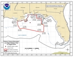
Trajectory Forecasts
Trajectory forecasting has been discontinued as of August 23, 2010. NOAA's Office of Reponse and Restoration (OR&R) modeling team generated daily trajectories for 107 days, beginning April 21. As of July 31, no recoverable surface oil has been observed. If any surface oil is observed, OR&R will resume trajectory forecasts.
Closures
For the latest closure information, see Deepwater Horizon/BP Oil Spill: Federal Fisheries Closure and Other Information [leaves OR&R site].
Modeling and mapping the actual and projected spill area is not an exact science. NOAA Fisheries Service strongly advises fishermen not to fish in areas where oil or oil sheens (very thin layers of floating oil) are present, even if those areas are not currently closed to fishing. Any changes to the closure are announced daily at 12 p.m. Eastern at sero.nmfs.noaa.gov [leaves OR&R site] and take effect at 6 p.m. Eastern the same day.
Sea Turtles and Marine Mammals
For information on sea turtle and marine mammals affected by the spill, please visit: Sea Turtles, Dolphins, and Whales and the Gulf of Mexico Oil Spill [leaves OR&R site] (NOAA Fisheries Office of Protected Resources) or Deepwater Horizon Response - Consolidated Fish and Wildlife Collection Report [leaves OR&R site] (Deepwater Horizon Web site).
Assessment
To help determine the type and amount of restoration needed to compensate the public for harm to natural resources as a result of the spill, a Natural Resource Damage Assessment (Document format: PDF, size: 90.8 K) will be conducted by NOAA and our co-trustee agencies. Although many agencies are involved in this process, NOAA is a lead federal trustee for coastal and marine natural resources, including marine and migratory fish, endangered species, marine mammals and their habitats. The focus currently is to assemble existing data on resources and their habitats and collect baseline (pre-spill impact) data. Data on oiled resources and habitats are also being collected. For additional information, see the DARRP Deepwater Horizon Web page.
Important Contacts
- For NOAA media inquiries, please contact Ben Sherman, John Ewald or Rachel Wilhelm or phone 301.713.3066.
- To offer suggestions to clean, contain or recover the oil visit Deepwater Horizon Response Suggestions. This Web site also provides procedures and forms for Alternative Response Tool Evaluation System (ARTES) proposals.
- For response-related inquiries, please phone the Joint Information Center (JIC) at 985.902.5231 or 985.902.5240.
- To report oil on land, or for general community information, please phone 866.448.5816.
- To report oiled or injured wildlife, please phone 866.557.1401.
- To learn about volunteer opportunities in all areas and what training is required, please phone 866.448.5816.
- To discuss spill related damage claims, please phone 800.440.0858.
- BP is asking fishermen for their assistance in cleaning up the oil spill. BP is calling this the Vessel of Opportunities Program and through it, BP is looking to contract shrimp boats, oyster boats and other vessels for hire to deploy boom in the Gulf of Mexico. To learn more about the Vessel of Opportunity Program, fishermen should phone 281.366.5511.
More Information about this Incident
Trajectory Maps • top
As of August 23, 2010, trajectory maps are no longer being produced. Trajectory maps produced by NOAA OR&R during the course of this spill are available in the Trajectory Map Archive.
The Loop Current is no longer a threat in this spill. For general Loop Current information, see the NOAA Atlantic Oceanographic and Meteorological Laboratory (AOML) page, Altimetry-Derived Products [leaves OR&R site].
|