Science Features
Audio clip: Adobe Flash Player (version 9 or above) is required to play this audio clip. Download the latest version here. You also need to have JavaScript enabled in your browser.
Transcipt and Details Two hundred years ago today, the central Mississippi River Valley was violently shaken by the first of a series of three earthquakes of magnitude 7 – 8 and hundreds of aftershocks greater than magnitude 3. By March 15, 1812, an estimated 2,000 aftershocks had been felt, but it is likely there were tens of thousands more that were not felt or otherwise noted.
The first of these quakes struck on December 16 around 2:15 a.m., near present-day Blytheville, Arkansas, waking residents located up to 900 miles away across what is now the eastern United States. According to reports of boat captains and others on the Mississippi River, the December 16 quake and its aftershocks caused the river to fill with debris as tree-covered banks caved into the river. Other reports said the river flooded large tracks of land, created temporary waterfalls, and even ran backwards in some places.

Video: Marion Haynes discusses the historic evidence of earthquakes
The second of the three major earthquakes, estimated at magnitude 7.5, occurred on January 23, 1812, at about 9:15 a.m. Similar to the December 1811 earthquake, this event was also widely felt. Damage occurred in an area of about 232,000 square miles.
The third and probably the most widely felt of the three major earthquakes occurred on February 7, 1812, at about 3 a.m. There were several destructive shocks that day, the last and largest estimated at magnitude 7.7. As a result, the town of New Madrid, Missouri, was severely damaged.
The New Madrid Quakes Not a One-Time Event
We know the 1811 – 1812 earthquake sequence was not a one-time event. The New Madrid earthquakes covered the region with sand blows, thousands of which remain today and can be seen as large, light-colored sandy patches in agricultural fields.
By digging into the sand blows, geologists found widespread evidence of pre-historic sand blows telling of similar sequences of earthquakes around 1450, 900, and 300 A.D. The USGS earthquake hazard map (http://earthquake.usgs.gov/hazards/), which is a compilation of scientific studies over the past 40 years, demonstrates the earthquake hazard revealed by this earthquake history.

Video: Tish Tuttle discusses the New Madrid Earthquakes
Similar Risk Exists Today
A risk of a similar sequence of earthquakes exists in the New Madrid Seismic Zone today and threatens Alabama, Arkansas, Illinois, Indiana, Kentucky, Mississippi, Missouri, and Tennessee. Recent USGS projections place the likelihood of a magnitude-6 or higher earthquake at about 25 – 50 percent over the next few decades and place the likelihood of a magnitude 7 or higher earthquake at 10 percent.
With large cities like Memphis, St. Louis, and Nashville well within range of a large-scale New Madrid earthquake, understanding the science of earthquakes and the area’s geologic history helps communities prepare for earthquake hazards and prevent them from becoming catastrophes.
Are You Prepared?
The USGS encourages citizens to join the thousands in eight States who have signed up to participate in the February 7, 2012, Great Central U.S. ShakeOut drill. The 200th anniversary of the New Madrid earthquakes is an opportune time to consider earthquake preparedness and learn about the region’s earthquake history. Go to the ShakeOut website to sign up for the drill, learn preparedness tips, and learn how to “Drop, Cover and Hold On” during an earthquake.
A newly released handbook from the USGS can help people in the central United States to prepare for earthquakess. “Putting Down Roots in Earthquake Country – Your Handbook for Earthquakes in the Central United States” provides detailed information about the threat of earthquakes in this part of the country, particularly along the New Madrid and Wabash Valley seismic zones.
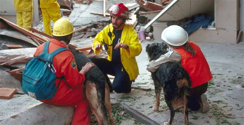
Scientists and communities are working together to make science more useful and communities safer. What one emergency manager has to say.
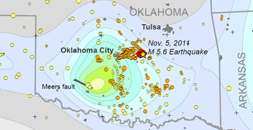
Shaking from Oklahoma's M5.6 main shock, the largest quake in the State's history, was felt from St. Louis to Lubbock. Number of quakes increasing in Oklahoma
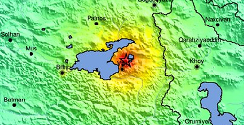
A magnitude-7.2 earthquake struck eastern Turkey on Sunday, October 23, 2011. History of strong earthquakes

It's only the beginning of their careers, but these 3 young scientists have forged ahead with innovative research at the frontiers of science. How they've transformed their fields
Oct. 9-15, 2011, is Earth Science Week, themed "Our-Ever Changing Earth," and Oct. 12, 2011, is International Day for Natural Disaster Reduction. Answers to questions posed by a changing world
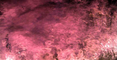
Fire managers and the public can access online maps of current wildfire locations, thanks to a Web-based mapping application provided by the USGS and its partners.
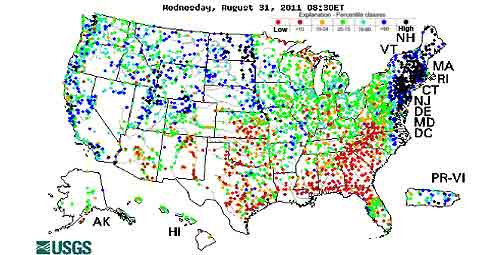
Rivers and streams are reaching record levels as a result of Hurricane Irene’s rainfall, with more than 80 USGS streamgages measuring record peaks.
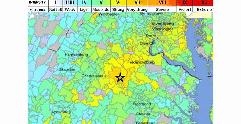
Tuesday, August 23, 2011 at 01:51 PM a 5.8 Earthquake occurred 38 miles outside of Richmond, VA.
A new geologic map of Lassen Volcanic National Park and vicinity has been created. The map area includes the entire Lassen Volcanic Center, parts of three older volcanic centers, and the products of regional volcanism.
To better understand and reduce tsunami hazards, USGS scientists examined sediment deposited by the tsunami in and around Sendai, Japan, as part of an international tsunami survey team organized by Japanese scientific cooperators.
USGS crews continue to measure streamflow and collect water quality and sediment samples in the Ohio and Mississippi River basins using state-of-art instruments.
Many communities in South Dakota, North Dakota, Montana, Colorado, Wyoming and Iowa are dealing with record floodwaters and bracing for more flooding in the upcoming weeks.
Fire managers and the public can access online maps of current wildfire locations, thanks to a web-based mapping application provided by the USGS and its partners.
New Zealand has experienced another damaging earthquake close to the city of Christchurch, which is still recovering from the magnitude-6.1 earthquake that struck in February. This latest quake has resulted in additional damage to buildings and infrastructure.
The USGS-NASA Landsat 5 satellite captured this image of 39-mile track of destruction caused by a massive tornado on June 1 near Sturbridge, MA.
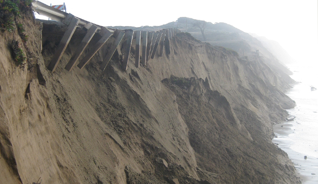
As hurricane season starts, researchers are modeling potential changes to coastal environments to identify communities vulnerable to extreme erosion during storms. Data collected before and after storm landfall are used to verify past forecasts and improve future predictions.
The effects of the March 11 magnitude 9.0 earthquake and resulting tsunami on Japan are being monitored using Landsat satellite data from the USGS.

The most recent earthquake in Japan affected water levels in groundwater wells all over the country. Water level fluctuations were recorded as far away as Illinois, Virginia, Missouri and Florida.

Volcanic activity continues in the Pu`u `O`o crater on Kilauea Volcano's east rift zone and in the Halema`uma`u Crater vent at Kilauea’s summit. Visit the USGS Hawaii Volcanoes Observatory site to get detailed Kilauea and Mauna Loa activity updates, recent volcano photos, recent earthquakes, and more.
Scientists unveil a catastrophic winter storm scenario that could possibly overwhelm California's flood protection system, and significantly disrupt Statewide social and economic systems.
Heavy rainfall could potentially destabilize hillsides. The USGS Landslide Hazards Web site has what you need to know if you live in an area prone to landslides.
The USGS and the National Weather Service have developed a new flood inundation map tool that enables management officials and residents to see where the potential threat of flooding is the highest along the Flint River near Albany, Georgia.

Volcanic eruptions have always been a part of human history; the American experience is no exception. On November 3rd, USGS’s Dr. John Eichelberger discusses new USGS programs which establish monitoring networks on all hazardous US volcanoes, to reduce the effects of volcanic hazards on communities.
Kilauea is Hawaii's youngest volcano and one of the world's most active. Get daily updates on ongoing eruptions from Kilauea's summit and east rift zone.
Looking for information on natural resources, natural hazards, geospatial data, and more? The USGS Education site provides great resources, including lessons, data, maps, and more, to support teaching, learning, K-12 education, and university-level inquiry and research.
The USGS PAGER system (Prompt Assessment of Global Earthquakes for Response) will now include estimated economic loss and casualty information. This system is used by emergency responders, government and aid officials, and the public to understand the scope of the disaster to develop the best response.
Flash flooding is one of the major causes of natural hazard-related deaths in the United States and is hard to predict, but data collected by the USGS is crucial to formulating better predictive models.
The USGS Science Strategy is a comprehensive report to critically examine the USGS's major science goals and priorities for the coming decade. The USGS is moving forward with these strategic science directions in response to the challenges that our Nation's future faces and for the stewards of our Federal lands.

On Nov. 3, USGS scientists Patrick Barnard and William Ellsworth will present a public lecture in Menlo Park, CA, providing Bay Area residents information about USGS research in the San Francisco Bay Area, including recent discoveries beneath San Francisco Bay and ongoing studies to better understand earthquake probabilities and the potential hazards associated with strong ground shaking.

Join USGS scientists on November 2nd to discuss the seismology of the M5.8 Virginia earthquake, its effects, and its context in the geology of Virginia.

![]() U.S. Department of the Interior |
U.S. Geological Survey
U.S. Department of the Interior |
U.S. Geological Survey
URL: www.usgs.gov/blogs/features/usgs_top_story/200th-anniversary-of-new-madrid-earthquakes/
Page Contact Information: Ask USGS
Page Last Modified: September 14, 2011