Showing posts with label USGS. Show all posts

Wednesday, March 16, 2011

Public Lecture: Treasures of the USGS Library

Wednesday, April 6, 2011, 7:00 PM
Title: Treasures of the USGS Library
By Richard Huffine
(PDF of Flyer  824 KB)
Since its creation in 1882, the USGS Library has grown to become the world's largest library dedicated to earth and natural sciences, holding more than 1.5 million volumes and 800,000 maps. Richard Huffine, Director of the USGS Libraries Program, will highlight some of the rarest, most valuable, and significant materials held by the USGS. These include early maps of America, documents that establish the provenance of the Hope Diamond, and documentation of our exploration of the American West by Hayden, King, Powell and Wheeler.
(PDF of Flyer  824 KB)

The Library’s initiative to digitize their collection for online access will make these cultural and historic records available worldwide to anyone at anytime. Join us and learn how the USGS is using history to inform the future directions of USGS research and scholarship.


The lecture, Treasures of the USGS Library, will be given on Wednesday, April 6, 2011, at 7:00 PM by Richard Huffine in the Dallas L. Peck Memorial Auditorium at the U.S. Geological Survey in Reston, Virginia.  See flyer for details.


(Photo: Title: Historia Mundi (1530).  This 479 year old volume is stored in a specially-made box that protects it from further damage by exposure to light. Photographer: Richard Huffine, U.S. Geological Survey

(Note: This article was originally published on the USGS Public Lecture Series web site)

Friday, June 11, 2010

First Detailed National Map of Land-Cover Vegetation Released Will Help Determine Places with Habitat to Support Wildlife

The most detailed national vegetation U.S. land-cover map to date was released today by the U.S. Geological Survey (USGS). The map will enable conservation professionals to identify places in the country with sufficient habitat to support wildlife.

The map, produced by the USGS Gap Analysis Program (GAP), can be viewed online and downloaded for free.


“These data are critical for determining the status of biodiversity, as baseline data for assessing climate change impacts, and for predicting the availability of habitat for wildlife,” said John Mosesso, Gap Analysis Program Manager. “Large datasets of this type are extremely important to land and wildlife managers because they allow for analysis and planning across extensive geographic areas.”

The GAP national land cover data, based on the NatureServe Ecological Systems Classification, is the most detailed, consistent map of vegetative associations ever available for the United States and will help facilitate the planning and management of biological diversity on a regional and national scale.

GAP’s mission is to keep common species common by providing information on the status of native species. The creation and dissemination of the national landcover dataset and online map viewer furthers that goal by putting crucial information into the hands of conservation professionals. Information about land cover is a key component of effective conservation planning and the management of biological diversity. 


Landcover Map Portrays Complex Data
The final version of the landcover map contains 551 Ecological Systems and modified Ecological Systems (the modified ecological systems represent 32 land use classes which depict developed and/or disturbed land cover classes). The map combines data from previous GAP projects in the Southwest, Southeast, and Northwest United States with recently updated California data. For areas of the continental United States where ecological system-level GAP data has not yet been developed, data from the LANDFIRE project compiled by Landscope was used. This allows for the construction of a seamless representation of ecological system distributions across the continental United States.

The map also meets natural resources agencies’ need for a way to characterize land cover. Finally, the new map furthers the mission of GAP to promote conservation by providing state, regional, and national assessments of the conservation status of land cover types to resource managers, planners, and policy makers who can use the map and its underlying data to make informed decisions.


Online Map Viewer Shows Data at Multiple Scales
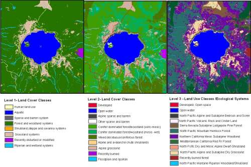
The online map viewing interface has been designed to allow users to explore land cover data at three levels of complexity.  Level 1 contains eight classes: grassland, shrubland, forest, aquatic, sparse and barren, recently disturbed, riparian, and human land use. Level 2 contains 43 classes, and incorporates information on elevation and climate. Level 3 contains the full 583 classes. This online tool facilitates exploration of ecological system distribution patterns at multiple scales and allows users to calculate statistics on the types of vegetation occurring within a mapping zone, a state, or a county.

As part of the USGS National Biological Information Infrastructure (NBII) — a collaborative program coordinated by the USGS to provide increased access to data and information on the nation’s biological resources — GAP data and associated analytical tools have been used in hundreds of applications, from basic research to comprehensive state wildlife plans, and from education projects in schools to ecoregional assessments of biodiversity.

GAP has developed land cover data since the 1980s — initially on a state-by-state basis and more recently on a regional basis. The national land cover map provides seamless coverage across political boundaries, facilitating its use by governmental agencies, researchers, conservation organizations and others.

(Photo: Online Map Viewer for Land-Cover Classification Map. The GAP (GAP Analysis Program) online map viewer shows land cover classifications at three levels. Courtesy of the U.S. Geological Survey Multimedia Gallery)
(This technical announcement was originally published by the U.S. Geological Survey)

Monday, February 22, 2010

Tom Hermann of the U.S Geological Survey's Biological Informatics Office Named 2009 Fellow by the American Association for the Advancement of Science

Tom Hermann of the U.S Geological Survey’s Biological Informatics Office, was recently named a 2009 Fellow by the American Association for the Advancement of Science (AAAS).

Hermann’s distinguished work at USGS has produced outstanding efforts to advance biological science and its communication. BIO’s mission is to create the informatics network, provide the scientific content, and develop public and private partnerships needed for the understanding and stewardship of the nation’s biological resources.

Tom Hermann

“We’re so pleased and proud that Tom has gained this honor,” said Gladys Cotter, USGS Associate Chief Biologist for Information and head of BIO. “It’s a tribute to his talents that also speaks well of the efforts of so many of the information, scientific and communications professionals he works with at USGS, other government agencies and numerous organizations worldwide.”

As Chief Knowledge Manager, Hermann oversees all formulation and communication of the USGS-National Biological Information Infrastructure (NBII) Program, one of BIO’s core components. As such, Hermann ensures all manner of biological information is made available to U.S. citizens quickly, reliably and efficiently. These data and information are distributed through a variety of formats and channels, including webpages, digital images, geospatial referencing data and a wide range of scientific and outreach publications.

Hermann has worked closely with the Department of the Interior on many topics of interest, such as amphibians. He helped shape strategies to improve access to amphibian knowledge and scientific information (nearly every state has reported noteworthy cases of amphibian deformities). Action from the NBII Program, managed by Hermann, included the development of NBII FrogWeb, an interactive website that provides current research and information. The department, the National Wildlife Federation, and the public television series, Kratt’s Creatures, also participated. This was the first time a partnership with other government agencies and non-government organizations provided integrated access to amphibian data and information.

Hermann is also responsible for the continuing growth and sophistication of the NBII Library of Images From the Environment (NBII LIFE), a collaborative platform for agencies, organizations and individual partners to share high-quality, authoritative images of the natural world. Subjects cover species, species interactions, landscapes, research, management and environmental topics. The goal is to manage images as scientific records and ensure they are useful for future research and decision-making.

At the international level, Hermann’s leadership in the development of the NATO Scientific, Technology, and Research Network (STARNET) grew out of his chairmanship of the Information Management Committee of the NATO Research and Technology Agency. He developed STARNET to facilitate access to information elements already existing within NATO agencies and NATO member countries in science, technology and overall research. This is the first time in the history of the NATO alliance that member countries can access these data using a one-stop interface. Hermann continues to lead a team of experts in information science in content development of STARNET’s Environmental and Biological Sciences Information Node. This vital NATO capability impacts the bureau as well as the scientific community and, by its very nature, is also helping to contribute to our national security.

Hermann holds a B.A. in Communications from the University of Maryland and an M.S. in Information Resource Management from Syracuse University. His awards at USGS have included the Meritorious Service Award, which may be granted for an important contribution to science or management, a notable career, and superior service in administration or in the execution of duties.

**Note: this article was published by the US Geological Survey, released on February 18, 2010. Visit the USGS Newsroom for more information. You can also subscribe to USGS News Releases via their electronic mailing list or RSS feed.

Friday, December 18, 2009

NASA Grant Team Developing Project Plan for Work on the Appalachian Trail

Glenn Holcomb of the USGS Northeast Area and Marcia McNiff of the National Biological Information Infrastructure (NBII) are participating as members of a team collaborating on the development of a Project Plan for work along the Appalachian Trail. The multi-agency team, led by principal investigator Dr. YQ Wang of the University of Rhode Island, also includes members from the National Park Service, the U.S. Forest Service, NASA, the Appalachian Trail Conservancy, the State University of New York (SUNY) College of Environmental Science and Forestry (ESF), and the University of Rhode Island. The project, “A Decision Support System for Monitoring, Reporting and Forecasting the Ecological Conditions of the Appalachian National Scenic Trail,” was selected for funding by NASA’s 2008 Decision Support through Earth Science Research Results Program. On completion, data and models developed over the 4-year life of the project will be hosted on the Appalachian Trail (A.T.) MEGA-Transect Web site.

(Image: Appalachian National Scenic Trail Map [Copyright: U.S. NPS])

Central Southwest/Gulf Coast Information Node Working With State Agencies to Develop Coastal Fisheries Mapping Application

Gulf of Mexico coastal fisheries populations have tremendous value in ecological, economic, and social terms. As a result, a number of state agencies within the Central Southwest/Gulf Coast Information Node (CSWGCIN) region are involved in coastal fisheries management. Each agency collecting fisheries independent (non-harvest) data in the Gulf of Mexico Coastal Zone does so according to agency-specific mission and goals; this leads to differing sampling methodologies and database formats. While each database tells a part of the story about the state of Gulf of Mexico coastal fisheries resources, combining them into a cohesive and complete data record is a difficult task. CSWGCIN is currently working with several of the state agencies to acquire coastal fisheries monitoring data. The data will be displayed in an online mapping application so users will be able to view physical characterization data by estuary. The application will provide hydrologic information, with data available for download.

Friday, November 13, 2009

What’s Protected, What’s Not: New Protected Areas Database for United States' Land Now Available

Several federal, state, and non-government agencies have combined resources and data about public landholdings to create the Protected Areas Database - United States (PAD-US).

PAD-US, released in April 2009, is a national inventory of protected lands. In addition to providing comprehensive information about public lands in the United States, this geodatabase includes information that allows it to be incorporated into the United Nations' World Protected Areas Database (WDPA), thereby aiding a new perspective on conservation efforts worldwide.

PAD-US was prepared in collaboration with the PAD-US Partnership, a public-private planning consortium comprised of federal, state, and non-governmental organizations interested in the inventory and management of protected lands.

"This effort, which was funded by the U.S. Geological Survey's Gap Analysis Program (GAP) and the Doris Duke Charitable Foundation, seeks to provide the guidance and resources necessary to maintain protected lands data with greater accuracy and detail than previously possible," said John Mosesso, a USGS scientist involved with the project.
To read more of the official USGS press release, visit the USGS Newsroom.

More information on the PAD-US Partnership can be found on the Protected Areas Database website, as well as a map of the stewardship data.

Tuesday, October 13, 2009

USGS Cooperative Fishery Research – Data Project

Alan Friedlander, formerly with NOAA Fisheries National Ocean Service (NOS)/National Centers for Coastal Ocean Science (NCCOS) joined USGS in 2009. Alan is taking over for Jim Parrish, as adjunct faculty at University of Hawaii-Manoa and lead of the Hawai’i Cooperative Fishery Research Unit. With assistance from Pacific Basin Information Node (PBIN) staff, Alan is organizing data related to fish biomass and protected area studies dating back to the early 1970s from field sites throughout the Hawaiian archipelago. PBIN staff and collaborators are assisting with data integration, migration to modern relational database structure, and updates of valid taxonomic names. Alan has several million individual observation records describing hundreds of unique fish species.

(Photo: Maui, Hawaii, man fishing. Credit: John J. Mossesso, NBII Life photos)

Tuesday, July 7, 2009

NBII and GBIF booth at ESA Conference 2009 in Albuquerque, New Mexico

The USGS National Biological Information Infrastructure (NBII) and Global Biodiversity Information Facility (GBIF) will have a joint booth in the exhibits hall. The USGS-NBII is the U.S. national node of GBIF. You are especially invited to come and learn how to install and use the new GBIF Integrated Publishing Toolkit (IPT), for enabling access to, sharing, and integration of your specimen and observation records with those of the international community.

The Ecological Society of America 94th Annual Meeting will be held August 2-7, 2009 in Albuquerque, New Mexico. Visit the ESA website for more information and registration.

On Friday, August 7, 2009 from 8:00 AM-11:30 AM in the Brazos, Albuquerque Convention Center, Annie Simpson from the US Geological Survey will be leading the session on Standards, Protocols, and Tools for Sharing Ecological Information: Data Interoperability on a Global Scale (session OOS 49). Liz Sellers will be facilitator for this oral session. Other USGS representation will include Annette Olson, Viv Hutchison, and Lisa Zolly. For more details, visit the OOS 49 session page of the ESA website.

Organizer: Annie Simpson, US Geological Survey
Co-organizers: Elizabeth Sellers, National Biological Information Infrastructure, and Viv Hutchison, US Geological Survey

Tuesday, June 23, 2009

USGS Microbiology Web Site Debut

USGS scientists across disciplines are using their microbiology expertise to study climate change, fish and wildlife disease, bioremediation, energy, and other national issues. The week of June 29, USGS will reveal the scope of USGS microbiology research with the release of the new Interdisciplinary Microbiology Web site. Research summaries and images, and contact information for scientists, are just some of the site’s assets that will facilitate collaboration between scientists and increase the understanding of USGS microbiology to the public. Goals of the site were developed at the USGS Interdisciplinary Microbiology Workshop and the content, look, and feel built with scientists' feedback. The site will soon be available at , and is made possible by the USGS National Biological Information Infrastructure (NBII) and USGS Microbiology Coordinator Kay Marano Briggs. For more information, contact Kay Marano Briggs, Reston, VA, 703-648-4046 or Bernadette LeMasters, Reston, VA, 703-648-4334)

Image: Paenibacillus thiaminolyticus
Catherine A. Richter,
USGS Columbia Environmental Research Center
Description: Yellow color shows thiamine degradation on an agar plate of
Paenibacillus thiaminolyticus strain 8120.

Monday, June 15, 2009

Protected Areas Database for the United States Now Available

The U.S. Geological Survey (USGS) NBII Gap Analysis Program (GAP) and the Doris Duke Charitable Foundation (DDCF) have joined forces to design the most collaborative and current protected areas database of our nation (PAD-US). The vision of this group, the PADUS Partnership, is to provide guidance and resources to maintain protected lands data with greater accuracy anddetail than was previously possible. The Partnership defines protected areas as “lands dedicated to the preservation of biological diversity and to other natural, recreational, and cultural uses managed for these purposes through legal or other effective means” and includes the USGS, Bureau of Land Management, U.S. Forest Service, Conservation Biology Institute, GreenInfo Network, and The Nature Conservancy (TNC). In April 2009, GAP aggregated the first version of the Protected Areas Database of the United States (PAD-Usv1) on behalf of the PAD-US Partnership. These data are required to fulfill GAP’s mission to provide state, regional, and national assessments of the conservation status of native vertebrate species and natural land cover types and to facilitate the application of this information to land management activities. To fulfill the NBII mission to facilitate the widest possible access to and use of biological data and information, GAP worked with the United Nations Environment Programme (UNEP) World Conservation Monitoring Centre (WCMC) to link PAD-US to the World Database on Protected Areas (WDPA). In addition, the PADUS database will be submitted annually to the Commission for Environmental Cooperation (CEC.org) for integration into the North American Environmental Atlas. These linkages will facilitate collaboration among conservation organizations and land managers by establishing a consistent understanding of protected lands status whether the focus is global or local. PAD-US is a geodatabase that combines administrative boundaries with attributes of ownership, management, and conservation measures. Available information includes: geographic boundaries of public land ownership and voluntarily provided private conservation lands (e.g., TNC preserves); a combination of land owner, manager, management designation, parcel name, and source of geographic information of each mapped land unit; International Union for Conservation of Nature category ; and GAP Status Codes intended to provide a measurement of management commitment for longterm biodiversity protection.


GAP categorizes protected areas (see PADUS map) as:

• Status Code 1: lands managed solely for biodiversity conservation in perpetuity

• Status Code 2: lands managed primarily for biodiversity conservation with some management (e.g., suppression of wildfire or activities designed to mimic natural disturbances)

• Status Code 3: lands having permanent protection from natural land cover conversion, but are subject to extractive uses (e.g., logging or mining)

• Status Code 4: lands not managed for conservation or for which there is no information

Protected areas are both uniquely and uniformly identified in the geodatabase by standardized parcel names and coded management designations. In addition, a parcel’s contextual setting is maintained through standardized attributes such as “Class” (Federal, Tribal, City, or Private) and “State Name.” Updates in several northwestern states (Washington, Oregon, Idaho, Wyoming, Montana, and California) are underway in addition to additional outreach and collaboration with data partners. The mission of GAP includes promoting conservation by providing broad geographic information on biological diversity to resource managers, planners, and policy makers who can use the information to make informed decisions. As part of the NBII — a collaborative program to provide increased access to data and information on the nation’s biological resources — GAP data and analytical tools have been used in hundreds of applications, from basic research to comprehensive state wildlife plans, and from education projects in schools to ecoregional assessments of biodiversity. GAP has developed protected areas information since the late 1980s. PAD-US demonstrates the collaborative efforts of the PAD-US Partnership to share data and leverage resources. PAD-US will be continually updated and improved. For more information, see <http://gapanalysis.nbii.gov/PADUS> or contact John Mosesso, Gap Analysis Program Manager.