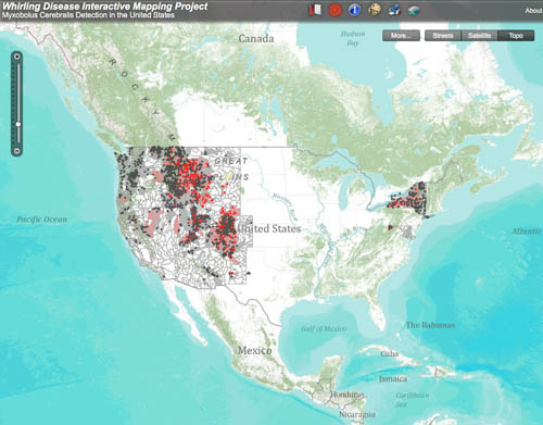
Working with the Big Sky Institute at Montana State University, the Whirling Disease Initiative is developing an interactive GIS-based map of the whirling disease parasite's known distribution in the United States. The user can zoom, pan, navigate around the map and display point data with limited descriptors. Like the gallery of static maps, the geographic coverage in the interactive map is currently being expanded. If you are not adept with GIS applications, a few minutes with the “help” and “quick tour” functions would be very worthwhile.
Notes on the data: This map is intended for general informational purposes and data were obtained from a variety of sources. Some of the map layers can be viewed at scales finer than the resolution of the data, therefore spatial inaccuracies may exist. The Whirling Disease Initiative assumes no liability for the information provided.
Data for the interactive map was obtained from a variety of state sources, as well as the USFWS Wild Fish Health Survey Database (WFHS). For this reason, the amount of information for each sample point is not consistent across all points. The date of the data ranges from 1988 to 2006, and varies with each state.
| USFWS, 1997-2008 |
| USFWS, June 2009 |
CDOW & USFWS, 2007
Watershed designations are based on the most recent data (2007). CDOW point data is included up to 1999 and USFWS WFHS data is included up to 2007. |
| IDFG & USFWS, 1987-July 2007 |
| Maryland DNR, 1995-2008 |
| MTFWP & USFWS, 1998-July 2007 |
| NDOW & USFWS, June 2009 |
| NMFG & USFWS, 1998-2008 |
| NYDEC & USFWS, 1994-January 2006 |
| ORFW & USFWS, June 2009 |
| UDWR & USFWS, 1991-July 2007 |
| USFWS, June 2009 |
WYGF & USFWS, 1988-2007
Data from the state is primarily available for positive detections of M. cerebralis; negative sampling events are largely unreported.
|
View the Interactive Map!
Browser Compatibility
This interactive mapping application, built using ESRI's ArcGIS Server 9.2, is known to support the following browsers under most configurations:
*Firefox 1.5 and higher
*Netscape Communicator 8.1 and higher
*Internet Explorer 6.0 and higher
While provisional support has been reported for Apple’s Safari 3 for Windows, the application is known to be incompatible with Safari for Mac OS X, and support of additional browsers (e.g., Opera) is undetermined. If you encounter problems using the application based on your configuration, we would appreciate hearing from you; please contact tnaberhaus@montana.edu. Thank you.
Back to Maps Home
Submit a Comment
