Assessing the Causes, Consequences and Spatial Variability of Burn Severity
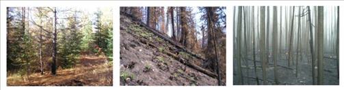
The USDA/USDOI Joint Fire Sciences Program funded the Rapid Response project "Assessing the Causes, Consequences and Spatial Variability of Burn Severity" to be conducted during and after active fire incidents. We have sampled on nine large wildfires in Montana, California and Alaska. Our team quantifies conditions before, during and after fires burn. Our goal is to understand the spatial variability in fire effects and to explore relationships between burn severity and fuels, fire behavior, local weather and topography.
We work closely with and share data and results with Fire Use, Incident Management, and Burned Area Emergency Response (BAER) teams. We will provide an improved set of quantitative indicators of burn severity that are scalable and mappable from the ground, using satellite and airborne hyperspectral imagery.
Our data will be useful to fire managers making challenging, timely decisions and in building the next generation of fire behavior and fire effects models.
Project Objectives:
- Develop and validate quantitative indicators of burn severity, including both overstory and soil surface effects, from field and remote post-fire measurements in a variety of sites (e.g. vegetation, topography, soils, parent material) and burning conditions.
- Assess the accuracy of the delta normalized burn ratio (dNBR) and other remote measures of burn severity across a range of burn severities.
- Quantify spatial variability in burn severity (both in the field and remotely) in terms of tree mortality and other overstory effects, soil surface effects and water repellency, and combined effects, across a range of fuel and site conditions.
- Model how spatial variation in fuel, topography and weather influences fire behavior and effects across a variety of fire-adapted ecosystems.
- Identify and widely share efficient sampling and remote sensing methods for rapid assessment of fire effects to assist strategic fire management before (e.g., fuels management) during and after (e.g., rehabilitation) wildfires.
Contacts:
-
Penelope Morgan
- University of Idaho - Dept. of Forest Reources
- E-mail: pmorgan@uidaho.edu
- Phone: (208) 885-7507
-
Andrew Hudak
- USDA Forest Service, Rocky Mountain Research Station
- E-mail: ahudak@fs.fed.us
- Phone: (208) 883-2327
-
Pete Robichaud
- USDA Forest Service, Rocky Mountain Research Station
- E-mail: probichaud@fs.fed.us
- Phone: (208) 883-2349
-
Kevin Ryan
- USDA Forest Service, Rocky Mountain Research Station
- E-mail: kryan@fs.fed.us
- Phone: (406) 329-4807
-
Keith Lannom
- USDA Forest Service, Remote Sensing Applications Center
- E-mail: klannom@fs.fed.us
- Phone: (801) 975-3765
-
Terrie Jain
- USDA Forest Service, Rocky Mountain Research Station
- E-mail: tjain@fs.fed.us
- Phone: (208) 883-2331
-
Paul Gessler
- University of Idaho, Dept. of Forest Resources
- E-mail: paulg@uidaho.edu
- Phone: (208) 885-8595
Partners: