1-minute water
level data
Tsunami Stations Web Page
Important Links:
NOAA's Role in a National Tsunami Warning System
West Coast and Alaska Tsunami Warning Center
Pacific Tsunami Warning Center
NOAA Tsunami Warning Capabilities
Deep-ocean Assessment and Reporting of Tsunamis (DART™)
Pacific Marine Environmental Laboratory (PMEL)
International Tsunami Information Centre
National Tsunami Hazard Mitigation Program
1-Minute Water Level Data
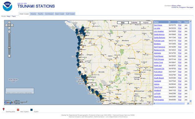
The tsunami capable tide stations application at http://tidesandcurrents.noaa.gov/tsunami
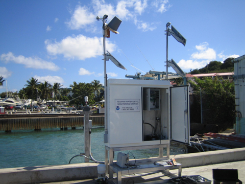
Tsunami Water Level Monitoring Station: Christiansted Harbor, St. Croix
Upgraded tide stations are equipped with new hardware and software to enable collection and dissemination of 1-minute water level sample data. In order to facilitate data transmission and dissemination, the NOAA TWCs receive water level data in a variety of ways. The Pacific Tsunami Warning Center, located in Ewa Beach, Hawaii is responsible for issuing tsunami warnings for the majority of the Pacific Basin, including the Pacific Islands, as well as the Caribbean. The West Coast and Alaska Tsunami Warning Center, located in Palmer, Alaska, is responsible for issuing tsunami warnings for the US West, Alaskan, Atlantic, and Gulf of Mexico coasts, as well as the west coast of Canada. (For more information on areas of responsibility, please see: http://www.prh.noaa.gov/ptwc/responsibilities.php)
In addition to having access to raw water level data via satellite transmission, CO-OPS collaborated with the TWCs to develop a web page to disseminate 1-minute water level data. This web page allows users to view both 6 and 1-minute data numerically or graphically for all tsunami-capable tide stations in increments of up to four days. While data for a particular station or time period may not contain a tsunami signal, the high rate data collection provides easier detection of tsunami signals when these events occur.
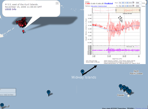
November 2006 Kuril Islands Tsunami as observed at the Midway tide station. (Red dots indicated earthquake epicenters, as reported by the US Geological Survey, blue dots indicate active tide stations)
Disclaimer: All water level data displayed through the CO-OPS Tsunami Web Page are raw and unverified. These data have not been subjected to the National Ocean Service's quality control or quality assurance procedures and do not meet the criteria and standards of official National Ocean Service data. They are released for limited public use as preliminary data to be used only with appropriate caution.
While CO-OPS disseminates this raw 1-minute water level data from its NWLON stations, the Tsunami Warning Centers are responsible for integrating these data with observations at Deep-Ocean Assessment and Reporting of Tsunami (DART™) buoys, coastal tide stations operated by the National Weather Service and international agencies, and seismic data collected by the National Weather Service and the US Geological Survey to issue tsunami warnings and guidance. NOAA also plays a role in hazard assessments (through forecast and inundation models), and preparedness and response. For more information about NOAA's role in tsunami warning guidance, and for links to contacts on specific non-water level questions, please see http://www.tsunami.noaa.gov/noaa_what.html.