


Mapping Gateway
Maps and Geographic Information
Google Maps and Google Earth Data
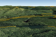
A Google earth view of existing cross-
country ski trails in a part of the
Adirondacks.
Google Maps and Google Earth show you DEC's data in interactive maps with satellite imagery, photographs, local business information and driving directions. Google Earth allows map data to be viewed in a 3D virtual environment.
Map Collection
The Map Collection contains non-interactive (static) maps that you may view, save or print. You can find maps on hunting, fishing, recreation, wildlife and other topics
Interactive Maps
Each interactive map contains data on a certain topic or theme, including nature, environmental facilities, and minerals. You can use interactive tools to explore the data and create customized maps.
Geodata Inventory

The State Lands Interactive Mapper is
an excellent tool for hunters to use to
view the boundaries of wildlife manage-
ment areas in detail.
The Geodata Inventory is a catalog that provides descriptive information about how, when and by whom a specific set of data was collected and how the data is formatted and accessed. Some data sets can be viewed in the interactive Map Viewer.
Browse Geodata Inventory - The inventory is organized by subject area and can be browsed to find a specific topic. In some cases, geodata listed in the inventory may be viewable from one of our web mapping applications. In other cases, it may be downloadable from the New York State GIS Clearinghouse or other sources.
Search Geodata Inventory - The inventory can be searched using a variety of tools based on specific criteria. Visitors can select location, keywords, categories, or time periods to base their search on.
