 OBIS-USA Node Manager Mark Fornwall of the USGS-National Biological Information Infrastructure (NBII) has been invited to address the Marine Mammal Commission at their annual meeting. The Commission has requested an update on the NBII marine theme, OBIS-USA
 Monday, November 30, 2009
USGS-NBII Scientist Invited to Address Marine Mammal Commission
 OBIS-USA Node Manager Mark Fornwall of the USGS-National Biological Information Infrastructure (NBII) has been invited to address the Marine Mammal Commission at their annual meeting. The Commission has requested an update on the NBII marine theme, OBIS-USA
 Tuesday, November 24, 2009
Summary Report Distributed on GISIN3: Global Invasive Species Information Network Standards Workshop

The National Biological Information Infrastructure (NBII) Invasive Species Information Node (ISIN) partner Discover Life and the Biology Department of Elmira College hosted a standards workshop of the Global Invasive Species Information Network (GISIN) in late July. View the 2009 Summary Report. Six data models are now implemented; the European Invasive Alien Species Gateway (DAISIE) is the latest data provider to come online in the beta system. For more information, visit the GISIN website.
Labels:
Biological invasions,
invasive species,
invasives
Thursday, November 19, 2009
Pacific Biodiversity Information Forum (PBIF) Highlights Updates to the Pacific Protected Areas Database
 Created in 2003, the Pacific Protected Areas Database (PPAD) is a work in progress to document protected areas in the Pacific islands region of Oceania (Micronesia, Melanesia, and Polynesia). Final data for the Federated States of Micronesia (FSM) and
 (Photo: from the PBIF website. PBIF's geographic scope includes the countries of Polynesia, Micronesia and Melanesia, as well as the Australasian countries bordering these regions.)
Climate Change, Bioenergy, and Aquatic Resources in the Southeast
The University of Tennessee's School of Information Science, has been awarded a cooperative agreement to develop content areas focused on climate change as well as bioenergy and aquatic resources (management and restoration) in the Southeast. Dr. Carol Tenopir is the Principal Investigator and with be supported by Dr. Miriam Davis. Dr. Tenopir is the Director of Research for the College of Communication and Information and the Director of the Center for Information and Communications Studies. Dr. Davis will initially focus on identifying significant research activities in the southeast related to these focus areas and assessing information needs.
Hawaii Early Detection Network
 The Maui County Early Detection Program, now called the Hawaii Early Detection Network, has expanded to support invasive species early detection outreach and community engagement throughout the state. This program supports community involvement in the search for incipient invasive plants and animals by means of outreach materials and technical reporting components. During the first half of 2009, the project Web site has been redesigned and updated; reporting system database components were implemented and tested; and outreach programs were initiated on the island of Hawaii and continued on the island of Maui.
View the Maui County Pest List of invasive species.
Get your own copy of the "eyes and ears" manual by becoming a certified pest buster. You can also download a copy of the Maui "Eyes and Ears" early detection manual (2 MB PDF) to get started.
Also, access the following reporting tools from the website:
- Early Detection Reporting Tool Information Flow Chart
- Online Reporting Tool Assessor Log-on.
If you are interested in participating in this project as an Eyes and Ears volunteer, or simply for more information, please contact reportapest-maui@hawaii.edu.
(Photo: Common mullein (Verbascum thapsus) has been eradicated from Maui, but is going wild in high elevation areas of the Big Island.)
Labels:
databases,
invasive plants,
invasive species,
invasives
Maui County Geospatial Technology Collaboration
 Pacific Basin Information Node (PBIN) is working with Maui Community College (MCC) and Maui to develop a geospatial information infrastructure, based at MCC that will serve as an archive and point of dissemination for cultural, natural resource, and urban landscape spatially referenced data. The technological infrastructure and source data sets (e.g., biodiversity data, culturally significant locations, historic structures, etc.) will provide a focal point for inter-disciplinary instruction, student internships, and hands-on work experience. For more information, visit the Pacific Basin Information Node (PBIN) website.
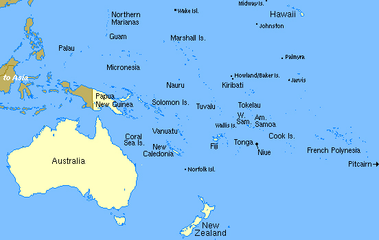
Photo: Geographic Location of Hawaii and the U.S. Pacific Island Territories (Guam, Commonwealth of the Northern Mariana Islands, and American Samoa)
Image Source: http://www.nsrc.org/OCEANIA/oceania.html
Friday, November 13, 2009
What’s Protected, What’s Not: New Protected Areas Database for United States' Land Now Available
 Several federal, state, and non-government agencies have combined resources and data about public landholdings to create the Protected Areas Database - United States (PAD-US).
PAD-US, released in April 2009, is a national inventory of protected lands. In addition to providing comprehensive information about public lands in the United States, this geodatabase includes information that allows it to be incorporated into the United Nations' World Protected Areas Database (WDPA), thereby aiding a new perspective on conservation efforts worldwide.
PAD-US was prepared in collaboration with the PAD-US Partnership, a public-private planning consortium comprised of federal, state, and non-governmental organizations interested in the inventory and management of protected lands.
"This effort, which was funded by the U.S. Geological Survey's Gap Analysis Program (GAP) and the Doris Duke Charitable Foundation, seeks to provide the guidance and resources necessary to maintain protected lands data with greater accuracy and detail than previously possible," said John Mosesso, a USGS scientist involved with the project.
To read more of the official USGS press release, visit the USGS Newsroom.
More information on the PAD-US Partnership can be found on the Protected Areas Database website, as well as a map of the stewardship data.
More information on the PAD-US Partnership can be found on the Protected Areas Database website, as well as a map of the stewardship data.
Monday, November 9, 2009
USGS NBII Scientist To Attend Ocean Biogeographic Information System (OBIS) International Meeting
OBIS-USA Node Manager Mark Fornwall of the USGS National Biological Information Infrastructure (NBII) has been invited to attend the Management Committee Meeting for the International OBIS program. The OBIS is a programme within the UNESCO International Ocean Commission, to provide access to marine biogeographic data. The meeting is part of a reorganization of OBIS within International Oceanographic Data and Information Exchange (IODE). The meeting will develop terms of reference and a plan of work for integrating biogeographic data contained in OBIS with the other data currently exchanged within the IODE. The meeting will take place in Ostende, Belgium, November 16-20, 2009 and travel is being partly covered by UNESCO.
Subscribe to:
Posts (Atom)

