In the 2012 President's Budget Request, the National Biological Information Infrastructure (NBII) is terminated. As a result, all resources, databases, tools, and applications within this web site will be removed on January 15, 2012. For more information, please refer to the NBII Program Termination page.
Image:
CAIN logo [Image: Allan Hollander, University of California Davis]
The California Information Node (CAIN) is a regional node of the National Biological Information Infrastructure (NBII). The primary mission is to provide access to critical biological and natural resources information that facilitates data integration, visualization, coordination, and collaboration to support the conservation of biodiversity in California.
From the deserts to the Redwood forests, California encompasses the most diverse biological region in the West. Home to more than 36 million residents, the state faces many issues that affect the landscape, wildlife, and people. Sharing and integrating information and data holdings from multiple institutions across the region can help address these challenges.
The California Information Node (CAIN) is a great place to find information about the state's variety of ecological areas. The state's incredibly diverse natural and political environment and the rapidly growing population interacts with complex natural features such as deserts, plateaus, rivers, and mountain ranges.
About the Node Read about the history of this regional NBII node and goals for the future.
Animals and Plants of the Region Learn about the region's native biodiversity, including amphibians, birds, fishes, invertebrates, mammals, plants, reptiles, and species in need of conservation.
Live Maps and Data Find maps and geospatial data related to California, including the GAP Analysis Program and the Art Shapiro butterfly site.
Regional Ecosystems Discover the diverse ecosystems and ecoregions of California.
Regional News Read news articles related to regional natural resource issues.
Regional Themes Explore regionally-significant topics such as fire, invasive species, water, and wildlife disease.
Featured Project
[Image: BIOS, California Department of Fish and Game]
The Biogeographic Information and Observation System (BIOS), overseen by the California Department of Fish and Game (DFG), is an interactive mapping program that integrates GIS, relational database management, and ESRI's ArcIMS technology to manage biogeographic data for the state of California. The BIOS project is part of an overall collaboration between the NBII, California DFG, USGS Western Ecological Research Center, and U.S. Fish and Wildlife Service (USFWS) to provide access to a wide variety of biological observation data and spatial information needed for conservation planning efforts across the state, known as the "Southern California Data Integration project".
Featured Project
Butterflies of California [Image: Art Shapiro Butterfly Site]
Access to long-term butterfly data for many species from central California, such as the woodland skipper (
Ochlodes sylvanoides
), is available through the Art Shapiro Butterfly Site. The site, developed in collaboration with the Information Center for the Environment (ICE) at the University of California, Davis, with support from the National Science Foundation (NSF) and the NBII, displays more than 35 years of data collected by Dr. Shapiro from the University of California-Davis in his continuing effort to monitor butterfly population trends on a transect across central California.
Conferences of Interest
There are currently no conferences.
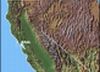
California Map
[Image: US National Atlas]
California elevations range from 14,495 feet at the peak of Mount Whitney to 282 feet below sea level at Death Valley.
The state contains nearly a third of all U.S. vascular plants totaling 5,047 of 15,890 and supports the greatest number of endemic plants at 2,153 species, subspecies, and varieties with one third
identified as rare, endangered, or threatened.
The NBII Program is administered by the Biological Informatics Program of the U.S. Geological Survey


![Butterflies of California [Image: Art Shapiro Butterfly Site]](https://cybercemetery.unt.edu/archive/nbii/20120110081411im_/http://www.nbii.gov/portal/server.pt/gateway/PTARGS_0_2_25720_206_921_43/http%3B/cbi-lap7.cbi.cr.usgs.gov%3B7097/publishedcontent/publish/geographic/southwest/cain_butterflies_featured_project/cain_featured_project_butterflies_of_california_1.jpg)
