 |
|
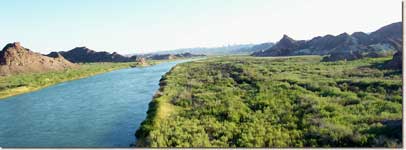
Introduced in the late 1800s, tamarisk, or saltcedar, is present along virtually all rivers in the semi-arid and arid West.
|
During the past century, thousands of non-native plants, animals, and pathogens have been introduced into all ecosystems in the United States. A growing number of these species have become "invasive," spreading at such a rapid rate that they have contributed to declines in native species and changes in ecosystem function. Invasive species incur substantial ecological, economic, and human health costs. In the U.S., this translates to an estimated $120 billion per year2. Increased human travel and trade, coupled with the changing types and patterns of environmental disturbance such as climate change and wildfire, are expected to exacerbate these impacts. Land and resource managers face the enormous challenge of identifying and locating invasive species in and around their jurisdictions, controlling what is already present, and preventing further proliferation or new invasions. The need has never been greater for an ecological forecasting capability that will address these urgent management needs and forestall what is in danger of becoming a disastrous trend.
In a joint effort to combat invasive species in the U.S., the U.S. Geological Survey (USGS) Fort Collins Science Center (FORT),NASA Goddard Space Flight Center, and Colorado State University (CSU) are combining resources and expertise in developing a National Invasive Species Forecasting System for the management and control of invasive species on all U.S. Department of the Interior and adjacent lands and waters.
 |
|
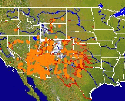
Mapping current distributions of tamarisk in the western U.S. is the first step in predicting further spread. |
Science partners will employ early detection and monitoring protocols and predictive models developed at FORT and CSU to process NASA and commercial remote-sensing data, and from these inputs create on-demand, regional-scale assessments of invasive species patterns and vulnerable habitats. The end product will be a dynamic and flexible system for generating electronic and paper maps of hot spots for potential exotic species invasions, be they plants, animals, or pathogens. Private and public national, state, and local management agencies will use these maps for remediation, management, and control. The forecasting system will be available to the natural resource management community through the Internet-based National Biological Information Infrastructure (NBII). FORT is co-developing the NBII Invasive Species Information Node through which this system will be made available to users.
Several factors brought FORT, NASA, and CSU together in this partnership. First, scientists in FORT's Invasive Species Science Branch, including Tom Stohlgren, have been engaged in ongoing research into the ecology of invasive species and vulnerable habitats to support prevention, early detection, assessment, containment, and, where possible, eradication of new invaders. Included in this work are investigations into the physical properties, composition, and hydrology of geologic substrates to identify lands vulnerable to invasion by exotic plants.
Second, FORT is the administrative home of the National Institute of Invasive Species Science, a growing consortium of partnerships between governmental and nongovernmental organizations that includes project partners NASA and CSU. This cooperative institute was established to work with others to coordinate data and research from many sources to predict the spread and reduce the effects of harmful nonnative plants, animals, and diseases in natural areas and throughout the U.S. The invasive species forecasting system is one of the most significant of these efforts.
Third, scientists in CSU’s Department of Forest, Rangeland, and Watershed Stewardship and its Natural Resource Ecology Laboratory offer predictive spatial modeling expertise through which CSU has become a major development ground for new spatial analysis techniques and mathematical models. These techniques and models are being incorporated into predictions of invasive species distributions and spread.
 |
|
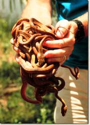
The brown tree snake has extirpated 10 bird species and most bats and lizards on Guam, and causes frequent power outages. Concerted efforts are underway to keep this snake from spreading to Hawaii and other Pacific islands. |
Finally, in helping the USGS and CSU to understand and develop predictive models for invasive species, NASA brings to the partnership its extensive remote sensing capabilities and super-computer expertise. NASA's space-based sensors and advanced computational, modeling, and information technologies provide state-of-the-art capability for collecting real-time data and developing the models to aggregate and analyze it on multiple scales. Just as important, NASA scientists offer the computational capabilities and expertise needed for large-scale, coupled-Earth-system modeling. They will work with USGS and CSU scientists in setting up the infrastructure and processes to ensure the successful transfer of this ecological forecasting system into operational use.
 |
|
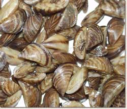
The zebra mussel, which can travel on trailered boats into new waterways, has caused millions of dollars in maintenance and removal costs in the Great Lakes and the Mississippi River drainage. |
The National Invasive Species Forecasting System is an application of extraordinary promise for managing one of the 21st century's most formidable threats of natural disaster. Over the next 10 years, this system will provide capabilities of fundamental importance to understanding and managing the effects of invasive species on human health, the economy, native biodiversity, and ecosystem processes in the U.S.
1 Portions of this Web feature appeared in an earlier article by the authors; see Schnase, J.L., Stohlgren, T.J., and Smith, J.A., 2002, The National Invasive Species Forecasting System: A strategic NASA/USGS partnership to manage biological invasions: Earth Observation Magazine, Vol. 11, No. 8, p. 46-49. Used with permission.
2 Pimental, D., and others, 1999, Environmental and
economic costs associated with non-indigenous species in the United States.
Cornell University, College of Agriculture and Life Sciences. Available
online at
http://www.news.cornell.edu/releases/Jan99/species_costs.html

![]() U.S. Department of the Interior | U.S. Geological Survey
U.S. Department of the Interior | U.S. Geological Survey
URL: http://www.fort.usgs.gov/resources/spotlight/EcoForecasting/default.asp
Page Contact Information: AskFORT@usgs.gov
Page Last Modified: 7:26:34 PM