NOAA activates GOES-15 satellite; deactivates GOES-11 after nearly 12 years in orbit
December 6, 2011
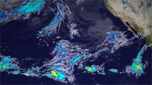
On Dec. 6, 2011 at 1545z, GOES-15 took its first infrared image as the operational geostationary satellite positioned over the Pacific - called GOES-West. This image shows a portion of that first image. The clouds are colorized based on their temperature, an indication of storm intensity. GOES-15 will continue to image the Western U.S. and Pacific every 15-30 minutes, with full hemisphere scans every 3 hours until its retirement - hopefully many years from now.
Download here. (Credit: NOAA)
For 12 years, GOES-11, one of NOAA’s geostationary satellites, tracked weather and severe storms that impacted the U.S. West Coast, Hawaii and the Pacific region. Today, NOAA began the process to deactivate the satellite, which is approaching the end of its useful life, and replace it with a new, more advanced spacecraft.
The new geostationary satellite, GOES-15, has taken the place of GOES-11 and now becomes NOAA’s GOES West spacecraft in a fixed orbit over the Pacific Ocean, midway between Hawaii and the West Coast and 22,300 miles above the equator. GOES-15 provides more data, with better resolution and image stability than GOES-11. GOES-15 joins NOAA’s other operational geostationary satellite, GOES-13, which serves as the GOES East spacecraft. The GOES are not only used for weather applications, but also track space weather, oceanographic changes, forest fires and other hazards and provide scientific data collection and information for search and rescue operations.
Aware that GOES-11 was nearing the end of its fuel supply, NOAA personnel spent the past several months planning for the end of its mission. Deactivation of GOES-11 began today when data observations were shifted to GOES-15. On December 15, NOAA will fire the spacecraft’s booster, moving GOES-11 approximately 185 miles (300 km) above its current geostationary orbit, where it will be officially decommissioned.
“With its steady eye on dangerous weather conditions, GOES-11 served America well, providing the critical images and atmospheric measurements NOAA meteorologists needed to produce life-saving forecasts,” said Mary Kicza, assistant administrator for NOAA’s Satellite and Information Service.
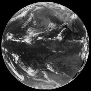
GOES-15 took its first operational full disk images at 1800z on Dec. 6, 2011. The image above was captured in native grayscale infrared. GOES-15's water vapor channel has major improvements over its predecessor on GOES-11 (the previous GOES-West).
Download here. (Credit: NOAA)
Launched May 3, 2000, GOES-11 was originally planned for a five-year mission, but lasted nearly seven years longer. “GOES-11’s extended service is testimony to the great work of Space Systems/Loral, NASA and the team of NOAA staff and contractors who acquired and managed the spacecraft ,” Kicza added.
In addition to GOES-15 and GOES-13, NOAA has two other geostationary satellites in orbit – GOES-12, which provides data for South America, and GOES-14, which is in a storage orbit as a ready backup or replacement.
NOAA is planning the next generation of geostationary satellites, called GOES-R, with the first set to launch in 2015. GOES-R is expected to more than double the clarity of today’s GOES imagery and provide more atmospheric observations than current capabilities with more frequent images. In addition, data from GOES-R instruments will be used to create many different products NOAA meteorologists and others will use to monitor the atmosphere, land, ocean and the sun.
NOAA’s mission is to understand and predict changes in the Earth's environment, from the depths of the ocean to the surface of the sun, and to conserve and manage our coastal and marine resources. Join us on Facebook, Twitter and our other social media channels.


