In the 2012 President's Budget Request, the National Biological Information Infrastructure (NBII) is terminated. As a result, all resources, databases, tools, and applications within this web site will be removed on January 15, 2012. For more information, please refer to the NBII Program Termination page.
Historical extent of prairie grasslands [Image: Aaron Jones, adapted from Ecoregions of the United States (map), Robert G. Bailey]
PrairieMap is a geospatial data clearinghouse. Users can download spatial data layers relevant to prairie research, management, and conservation of prairie grassland ecosystems in western North America.
Kansas
Once dominated by short-, tall-, and mixed-grass prairie, the biologically productive lands of this Great Plains state have been widely converted for agricultural use. Nearly 20 percent of all Kansans, rural and urban, are employed in jobs related to agriculture (National Agricultural Statistics Service, 2005).
Disturbance, drought, fire supression, sprawl, and other factors provide invasive plant species with opportunity, and native prairie plant species are in demise. Four hundred thousand square miles of Kansas' native prairie are protected in the Tallgrass Prairie National Preserve, and other groups are working to preserve additional parts of this unique landscape.
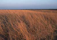
Kansas Prairie
[Photo: Jeff Vanuga, Natural Resources Conservation Service Photo Gallery]
These prairie species were seeded under the Kansas Conservation Reserve Program, a program of the Natural Resources Conservation Service.
The Conservation Reserve Program "provides technical and financial
assistance to eligible farmers and ranchers to address soil, water, and
related natural resource concerns on their lands in an environmentally
beneficial and cost-effective manner."
The NBII Program is administered by the Biological Informatics Program of the U.S. Geological Survey