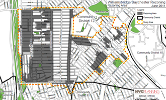
The Department of City Planning proposes to amend the Zoning Map on all or portions of 181 blocks in the Williamsbridge and Baychester communities to protect and preserve residential areas while fostering vibrant, inviting, and walkable residential and commercial corridors. The Department has developed the proposal in collaboration with Bronx Community Board 12, local institutions and elected officials.
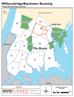
The areas affected by the proposed action comprise (1) the residential Williamsbridge neighborhood in the western part of the study area, (2) the residential Baychester neighborhood in the eastern part of the study area, and (3) the major commercial/residential corridors within the Williamsbridge neighborhood along White Plains Road, East 233rd Street and East Gun Hill Road.
Over the last several years, the residential neighborhoods in the rezoning area have been experiencing development pressure largely due to outdated zoning, which has generally remained unchanged since 1961.
The proposed actions are intended to achieve three primary objectives:
- Protect neighborhood scale and character by reinforcing existing development patterns;
- Update and add new commercial overlays to reinforce existing patterns of commercial uses;
- Create growth opportunities for areas around major corridors and mass transit.
The areas affected by the rezoning are:
- (1) Williamsbridge areas: The Williamsbridge neighborhood is generally defined as the area between Bronx Boulevard and Laconia Avenue. In addition, portions of two blocks along Lurting Avenue, south of East Gun Hill Road are included in this rezoning. A three block long portion of Holland Avenue is also included in the proposal. Residential lower density and contextual zoning designations are proposed for approximately 130 full or partial blocks in the Williamsbridge neighborhood to preserve the scale and context of these areas.
(2) Baychester areas: The Baychester neighborhood is generally defined as the area to the east of Laconia Avenue and west of the New England Thruway. Residential lower density and contextual zoning designations are proposed for approximately 29 blocks or block portions in the Baychester neighborhood to preserve the scale and context of these areas.
(3) Williamsbridge Residential/Commercial corridors: The rezoning area includes the predominantly commercial White Plains Road between East 233rd Street and East Gun Hill Road, East 233rd Street between White Plains Road and Paulding Avenue, and East Gun Hill Road between White Plains and Boston roads. Contextual districts are proposed along White Plains Road, East 233rd Street and East Gun Hill Road corridors to permit medium-density residential and commercial zoning districts along 60 full or partial blocks where current zoning limits residential and commercial uses. In addition 83 blockfronts along Bronxwood Avenue and Laconia Avenue, two thoroughfares which are mainly residential but contain significant commercial areas, are proposed to be rezoned to a moderate-density contextual district with slightly modified commercial overlays. In addition, the depths of commercial overlays are proposed to be adjusted, where appropriate, to reflect existing patterns of commercial development.
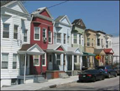
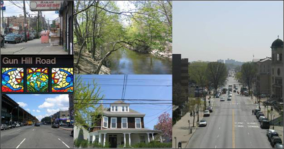
Row houses in the Williamsbridge neighborhood
|
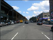
The rezoning area has many wide corridors, including White Plains Road, pictured, with the 2 and 5 Elevated Train
|
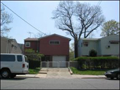
Smaller detached homes in the Baychester neighborhood |
|