In the 2012 President's Budget Request, the National Biological Information Infrastructure (NBII) is terminated. As a result, all resources, databases, tools, and applications within this web site will be removed on January 15, 2012. For more information, please refer to the NBII Program Termination page.
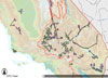
WREZ Phase 1 Map [Image: Western Governors' Association and U.S. Department of Energy]
The Renewable Transmission Energy Project is an initiative of the Western Governors' Association (WGA) and the the Western Interstate Energy Board to analyze how best to develop a Western regional market and transmission grid for high quality renewable energy resources in the Western Interconnection. The transmission planning process and analyses will consider impacts to wildlife and water resources to increase the long-term viability of selected transmission plans.
The current plan builds on the Western Renewable Energy Zones (WREZ) Initiative, a joint project of the WGA and the U.S. Department of Energy. The WREZ Phase 1 Report completed in June 2009, brought together diverse interests, information, and analytical tools to identify areas in the Western Interconnection for potential development of renewable energy resources with low environmental impacts. GIS layers used in this Phase 1 Report can be viewed and downloaded by logging on to the NREL WREZ GIS portal (Username: wrez and Password: guest).
Geothermal Legacy Collection
[Image: OSTI]
The Geothermal Legacy Collection is a searchable online database maintained by the Office of Scientific and Technical Information under the U.S. Department of Energy.
The web site allows users to search for technical and programmatic reports published in the last forty years. The reports included in the database are intended for a variety of users interested in factual information about geothermal energy.
Renewable Energy Atlas of the West
Renewable Energy Atlas of the West [Image: Energy Atlas]
The Renewable Energy Atlas of the West, created by a partnership of organizations
interested in renewable energy, highlights the wind, geothermal, solar, and biomass resources across the western United States.
The Atlas is available as an online document in which users can view the
entire Energy Atlas, or sections of it, in Adobe PDF. The web site also features the Renewable Energy Atlas of the West Interactive Map, provided by the National Renewable Energy Laboratory (NREL).
Live Maps and Data
This area of the RENEW website provides access to projects hosted by NBII partners that contain renewable energy information, maps, and data, as well as access to other featured renewable energy resources.
Projects include:
BIOS Renewable Energy Viewer Learn about renewable energy development in California and explore the BIOS Renewable Energy Viewer
The Energy Technology Data Exchange (ETDE) is an international energy information exchange agreement founded in 1987 under the International Energy Agency (IEA) to facilitate the sharing of energy research and technology information among member countries, including developing nations. ETDE World Energy Base, or ETDEWEB, is an extensive web-based database containing over 4 million literature references and more than 300,000 full text documents not typically available through conventional sources, with additional links to over 1 million full text documents. Topics include information on all aspects of energy research, science, and technology, including renewable energy and global climate change. ETDEWEB is maintained by ETDE's operating agent in the U.S., the U.S. Department of Energy's
Office of Scientific and Technical Information.
West-wide Energy Corridors on Public Lands
Electric towers at sunset [Photo: Warren Gretz, National Renewable Energy Laboratory's Photographic Information eXchange Collection]
The U.S. Department of Energy, the Bureau of Land Management, the U.S. Forest Service, and the Department of Defense prepared a Programmatic Environmental Impact Statement (PEIS) to evaluate issues associated with the designation of energy corridors on federal lands in eleven Western states. The Draft PEIS was issued in Fall 2007 and the Final West-wide Energy Corridor Programmatic EIS was made available in Fall 2008.
The National Renewable Energy Lab is a federal laboratory "dedicated to the research, development, commercialization and deployment of renewable energy and energy efficiency technologies". Two areas of the NREL website provide access to renewable energy data, maps, reports, and tools: the Renewable Resource Data Center (RReDC) and the Dynamic Maps, GIS Data, and Analysis Tools site. These sites provide access to information that can help guide renewable energy planning and siting.
American Wind and Wildlife Institute Mapping Initiative
[Image: AWWI]
The American Wind and Wildlife Institute (AWWI) is a 501c(3) non-profit dedicated to encouraging sustainable wind energy development and protecting wildlife and their habitat.
The Wind-Wildlife Mapping Initiative is currently being developed by AWWI in partnership with The Nature Conservancy (TNC). The tool, currently in its pilot phase, will be a landscape-scale, GIS-based planning tool that will map wind energy potential and relative wildlife risk across the country. It will assist future wind energy development efforts by informing site-specific planning and identifying potential issues and concerns. AWWI also plans to develop a Wind-Wildlife Research Information System, a web-based tool to manage information and data regarding wind energy and wildlife.
The NBII Program is administered by the Biological Informatics Program of the U.S. Geological Survey


![Renewable Energy Atlas of the West [Image: Energy Atlas]](https://cybercemetery.unt.edu/archive/nbii/20120111150150im_/http://www.nbii.gov/portal/server.pt/gateway/PTARGS_0_2_27068_1960_7197_43/http%3B/cbi-lap7.cbi.cr.usgs.gov%3B7097/publishedcontent/publish/ecological_topics/renewable_energy_project/nrel_energy_atlas/renew_renewable_energy_atlas_of_the_west_highlight__narrow__1.jpg)

![ETDEWEB logo [Image: ETDE]](https://cybercemetery.unt.edu/archive/nbii/20120111150150im_/http://www.nbii.gov/portal/server.pt/gateway/PTARGS_0_2_26425_1960_7197_43/http%3B/cbi-lap7.cbi.cr.usgs.gov%3B7097/publishedcontent/publish/ecological_topics/renewable_energy_project/etde_world_energy_base/renew_etde_world_energy_base_highlight_1.jpg)
![Electric towers at sunset [Photo: Warren Gretz, NREL]](https://cybercemetery.unt.edu/archive/nbii/20120111150150im_/http://www.nbii.gov/portal/server.pt/gateway/PTARGS_0_2_7222_1960_7197_43/http%3B/cbi-lap7.cbi.cr.usgs.gov%3B7097/publishedcontent/publish/geographic/southwest/swin_wafer_in_the_news/west_wide_energy_corridors_on_public_lands_1.jpg)
![NREL logo [Image: National Renewable Energy Lab]](https://cybercemetery.unt.edu/archive/nbii/20120111150150im_/http://www.nbii.gov/portal/server.pt/gateway/PTARGS_0_2_26427_1960_7197_43/http%3B/cbi-lap7.cbi.cr.usgs.gov%3B7097/publishedcontent/publish/ecological_topics/renewable_energy_project/nrel_renewable_resource_data_center/nrel_maps_and_data_resources_highlight_1.jpg)
![American Wind and Wildlife Institute Logo and Background [Image: AWWI]](https://cybercemetery.unt.edu/archive/nbii/20120111150150im_/http://www.nbii.gov/portal/server.pt/gateway/PTARGS_0_2_26423_1960_7197_43/http%3B/cbi-lap7.cbi.cr.usgs.gov%3B7097/publishedcontent/publish/ecological_topics/renewable_energy_project/awwi_mapping_initiative/renew_awwi_mapping_initiative_1.jpg)