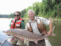
Gulf Sturgeon - Historic & Current Information
Gulf sturgeon are found in large
river systems from Louisiana to Florida. However,
very little is known about the distribution of these
fish outside of the large watersheds. In addition,
the fish may occupy only discrete areas in the watersheds
(all less than 100 miles long) during the summer and
are difficult to research. Furthermore, the upper
reaches of the river systems and numerous tributaries
are not thoroughly investigated for Gulf sturgeon
due to limited personnel and time constraints. The
Panama City Field Office initiated a study seeking
historic and current Gulf sturgeon information in
largely uninvestigated areas. Over 100 signs requesting
Gulf sturgeon information were placed at boat ramps
and high-use areas in Florida, Alabama, Mississippi
and Louisiana. Service personnel from Daphne, Ala.,
and others from Louisiana Department of Wildlife,
Fisheries and Parks, University of Southern Mississippi,
Mississippi State University and Troy State University
assisted with placing the signs.
Although response to the Gulf sturgeon
information request has been limited, several reports
are noteworthy. Recent Gulf sturgeon sightings in
the Mobile Delta, the Intercoastal Waterway near Orange
Beach, Ala., and a number of reports from anglers
fishing off Panama City Beach piers, indicate that
Gulf sturgeon are swimming along the Gulf coast.

Gulf Sturgeon Trawl Avoidance Study
The Panama City Field Office assisted researchers
from the University of Southern Mississippi (USM),
Louisiana Department of Fish, Wildlife and Parks,
National Marine Fisheries Service (NMFS) and other
U.S. Fish and Wildlife Service offices in Alabama
and Louisiana in a study to determine if Gulf sturgeon
were susceptible to being caught during winter shrimp
trawling operations. The Caretta, a 40-foot NMFS trawler,
made several passes through areas in the Mississippi
Sound offshore of Pascagoula, Miss., where adult Gulf
sturgeon equipped with sonic tags were located. A
camera attached in the throat of the trawl recorded
the forward progress of the trawl as it passed through
designated Gulf sturgeon locations. No Gulf sturgeon
were captured in the trawl or were recorded in the
trawl camera. Furthermore, triangulation telemetry
monitoring of a Gulf sturgeon indicated that the fish
moved away from the trawler on several successive
trawling attempts to capture the fish.
Gulf Sturgeon Diet Studies
The majority of Gulf sturgeon feeding and growth
periods occurs in the marine environment during the
winter. Panama City Field Office biologists, working
with University of Florida researchers, collected
five Gulf sturgeon in the Alaqua Bayou and Choctawhatchee
Bay in April 2003. The sturgeon were captured using
stationary sinking gill nets and ranged in weight
from 10 to 135 pounds. Food items were extracted from
the fish using a non lethal lavage procedure. Biologists
also conducted a follow-up study in the eastern portion
of Choctawhatchee Bay in May 2003, where 32 fish,
weighing from 1.5 to 57 pounds, were collected. Eleven
of 14 fish subjected to the lavage procedure yielded
food items.
Preliminary analysis of the food
items indicated that Gulf sturgeon collected in both
areas were feeding primarily on amphipods and lancelets.
All fish were released without any ill effects following
the procedure.
Juvenile Gulf Sturgeon
Movement & Habitat Use
Gulf sturgeon spend winter in marine estuaries, bays
and the Gulf of Mexico. It is during this period that
most of the species’ feeding and growth occurs.
Documenting the marine habitat use of Gulf sturgeon
is a priority task identified in the Gulf Sturgeon
Recovery/Management Plan, and very little information
is available regarding the over-wintering behavior
of juvenile Gulf sturgeon. Five juvenile Gulf sturgeon,
weighing from 2 to 4 pounds, were collected near the
mouth of the Choctawhatchee River in December 2002.
The fish were equipped with sonic tags and monitored
for six months. All five fish relocated at least once.
Three of the fish over-wintered in the eastern part
of the bay within 2.5 miles of the river mouth. Two
fish were located 10 to 15 miles away from the capture
location, but still within Choctawhatchee Bay. All
fish were located in near-shore habitat consisting
of sand or mud in less than nine feet of water. Salinity
ranged from zero at the river mouth to 1.5 ppt. at
the location of the fish farthest from the capture
site. In May 2003, one fish was located about 30 miles
upstream from the bay and original tagging area in
the Choctawhatchee River, known as a Gulf sturgeon
summer resting area.
Gulf Sturgeon Marine Movement & Habitat Use
Priority action items identified in the Gulf Sturgeon
Recovery/Management Plan include identification of
estuarine and marine habitat used by Gulf sturgeon.
Three Gulf sturgeon (two in the Apalachicola River
and one in the Yellow River) were equipped with pop-up
archival tags in October 2002 in an effort to document
Gulf sturgeon movement and habitat use during the
over-wintering period in marine waters. The pop-up
tags were attached to the base of the dorsal fin with
100-pound monofilament line. The tags, which record
water temperature, depth and light penetration (to
calculate geo-location), were set to release from
the fish during the first week in February 2003. Upon
release, tag data is transmitted to a satellite. In
addition, each fish was equipped with an external
sonic tag to monitor movement of the fish once the
pop-up tag was released.
Two pop-up tags in the Apalachicola
River fish transmitted location data while the remaining
tag in the Yellow River did not respond. One pop-up
tag surfaced in the Gulf of Mexico about one mile
off shore of Tyndall Air Force Base, a known area
for Gulf sturgeon over-wintering. This fish was located
by its sonic tag signature and was monitored prior
to and after its pop-up tag was released. The other
pop-up tag surfaced in the Gulf of Mexico about four
miles offshore, near the mouth of the Ochlockonee
River. The presence of the fish associated with this
tag could not be verified by sonic signature detection.
Two other Gulf sturgeon, one from the Choctawhatchee
River and one from the Apalachicola River, were located
in the Gulf of Mexico off Tyndall Air Force Base.
These fish were between 1/2 to 1 mile from shore in
water depths ranging from 12 to 20 feet. The fish
from the Choctawhatchee River was located in the same
area used during the previous winter.
An additional study to provide information
regarding Gulf sturgeon marine movement was initiated
in November 2002. Sonic receivers and data loggers
were placed on piers in Panama City Beach, Fla., and
Gulf Shores, Ala., in an effort to record coastal
movement of sonic-tagged Gulf sturgeon. The study
was terminated within three weeks after heavy seas
knocked the hydrophones off pier supports at both
sites. No data was obtained from either site.
Gulf Sturgeon Recovery Coordination
|
The Gulf sturgeon is one of several species protected under
the Endangered Species Act (ESA) for which the
Panama City Field Office is the lead office
for its recovery. Because the Gulf sturgeon
is an anadromous fish (migrating between salt
water and fresh water for spawning in fresh
water), the USFWS shares ESA responsibilities
for this species with the National Marine Fisheries
Service.
As lead recovery office for
the USFWS, we coordinate and track recovery
planning activities, recovery implementation,
population numbers, range occupied, amount of
take authorized, conservation measures for use
in Section 7 consultations, and Section 6 projects
(cooperative projects with the States). The
current range of the Gulf sturgeon extends from
Louisiana to peninsular Florida, so we coordinate
those various functions between several other
USFWS offices and with NMFS. Ultimately, when
recovery is achieved, we will prepare the documentation
for removing the species from the threatened
list.
Our office sponsors and conducts
projects that implement tasks outlined in the
Gulf Sturgeon Recovery Management Plan, including
studies to estimate population size and track
movements of fish from all four river systems
in Northwest Florida and adjacent Alabama that
are known to support reproduction. We recently
completed a survey of available spawning habitat
in these systems. Beginning in 1998 and annually
since 2000, we have organized or co-sponsored
an annual Gulf sturgeon workshop for scientists
and natural resource managers working towards
this species' recovery.
|
|