In the 2012 President's Budget Request, the National Biological Information Infrastructure (NBII) is terminated. As a result, all resources, databases, tools, and applications within this web site will be removed on January 15, 2012. For more information, please refer to the NBII Program Termination page.
The Southern High Resolution Modeling Consortium (SHRMC) is providing daily forecasts of ground level particulate matter concentrations resulting from wildfires in the southeastern U.S. using the BlueSky smoke modeling framework developed by the U.S. Forest Service. Forecast results are displayed using Google Earth which provides an intuitive interface for displaying spatial information. Visit http://shrmc.ggy.uga.edu/ge/ for more information and to use these products. (Posted June 4, 2007)
Fire Ecology
Fires in the southeastern United States have a direct effect on the biology, ecology, and economy of the region. Whether fires are naturally occurring or prescribed, having access to information describing impacts, benefits, prevention, and management is crucial. The Southeast Information Node works to provide information to:
Determine fire risk
Prevent wildfires
Study fire history
Keep up-to-date on the current safety procedures
Know how fire interacts with fuel, weather, and topography
Determine impacts to organisms and their environment
Use fire to restore/maintain ecosystems
Plan for emergency situations
A major partner in this effort is the Southern Fire Portal, part of the NBII's Fire Research and Management Exchange System (FRAMES). The goal of the Southern Fire Portal is to provides free and easy access to fire information through fire related publications, datasets, databases, decision-support tools, models, glossaries, interactive CD-ROMs, videos, and state-of-the-knowledge literature syntheses.
Southern Fire Portal
FRAMES - Southern Fire Portal
The Southern Fire Portal (SFP) is a geographic focus of the Fire Research and Management Exchange System (FRAMES).
The SFP improves fire science organization and accessibility by integrating and expanding three comprehensive, complementary sources of fire information:
As a nexus of fire effects information and technology transfer, the Southern Fire Portal is the Southeast's gateway for continuing collaboration between fire management and research communities and their publics.
Visit the SFP for fire-related research data, documents, projects, tools, and Web sites.
Wildfire and Drought
Prolonged drought lowers the normal moisture content of debris in forests and other wild lands, creating an overload of dry fuel in terrestrial ecosystems and increasing the potential for large, destructive wildfires. Prolonged dry spells tend to increase the intensity of forest fires as moisture content is rarely influenced by single precipitation events.
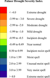
A popular measure of dryness is the Palmer Drought Severity Index, which factors temperature and rainfall information to estimate dryness for a localized area.
[Image: U.S. Geological Survey]
Using the Palmer index, normal conditions fall near zero, while "extreme drought" registers at minus 4 and "extremely moist spell" registers at positive 4.
Prolonged periods without rain stress plant communities, making them more susceptible to insects and disease and less competitive with invasive species. Dead and dying vegetation contributes further to the problem of excess dry fuel. Dry conditions also prevent use of prescribed fire, often used control invasive species.