In the 2012 President's Budget Request, the National Biological Information Infrastructure (NBII) is terminated. As a result, all resources, databases, tools, and applications within this web site will be removed on January 15, 2012. For more information, please refer to the NBII Program Termination page.
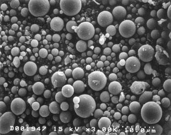
scanning electron microscope image of fly ash. [Image: United States Department of Transportation]
Description: Fly ash consists of silt-sized particles which are generally spherical, typically ranging in size between 10 and 100 micron. Fly ash can be tan to dark gray, depending on its chemical and mineral composition. Lighter colors generally indicate a high lime content, while brown color indicates iron. Dark gray to black hues reflect a higher unburned carbon content. Fly ash color is usually very consistent for each power plant and coal source.
Chemistry: Fly ash consists primarily of oxides of silicon, aluminum iron and calcium. Magnesium, potassium, sodium, titanium, and sulfur are also present to a lesser degree. Trace elements are also present alongside the remaining coal ash, including arsenic, selenium, mercury, and naturally occurring radioactive elements.
Disposal: The U.S. electric utility industry generates about 100 million metric tons of coal combustion waste annually. Just over half of this amount is fly ash. While some coal combustion waste is recycled, 70 million tons are disposed of in impoundments and landfills each year. Fly ash is the most frequently recycled type of coal combustion byproduct, commonly used in place of portland cement in concrete.
The Tennessee Valley Authority (TVA) Kingston fly ash spill occurred on December 22, 2008 when a 40-acre coal fly ash slurry storage pond at the TVA's Kingston Fossil Plant in Roane County, Tennessee, broke, releasing an estimated 5.4 million cubic yards of ash mixed with 327 million gallons of water to the environment. The coal fly ash slurry spread over nearly 300 acres of land adjacent to the plant and entered the Emory River, a tributary of the Clinch River, which flows to the Tennessee River.
Long-term environmental monitoring is now underway. Information related to assessing environmental impacts to biodiversity is posted to this page via a regularly updated RSS feed. Species information for sensitive Roane County species is also available on this page, as are news updates relevant to the ongoing activities related to the spill.
The slide presentation below highlights types organisms studied in environmental assessments of the effect of fly ash in the environment.
<p align="center">Can't see Flash? Install <a href="http://www.adobe.com/shockwave/download/download.cgi?P1_Prod_Version=ShockwaveFlash" _djrealurl="http://www.adobe.com/shockwave/download/download.cgi?P1_Prod_Version=ShockwaveFlash" target="_blank">Flash Player</a> or view the <a href="http://www.nbii.gov/portal/server.pt/gateway/PTARGS_0_737_17118_1527_5318_43/http%3B/cbi-lap7.cbi.cr.usgs.gov%3B7097/publishedcontent/publish/geographic/southern_appalachian/sain_species/east_tennessee_frog_calls_introduction/more_content.html" _djrealurl="http://www.nbii.gov/portal/server.pt/gateway/PTARGS_0_737_17118_1527_5318_43/http%3B/cbi-lap7.cbi.cr.usgs.gov%3B7097/publishedcontent/publish/geographic/southern_appalachian/sain_species/east_tennessee_frog_calls_introduction/more_content.html" target="_blank" title="Follow link to view an alternate, HTML version.">alternate version</a></p>
The multimedia content above requires Flash Player. If your browser does not support Flash Player, an alternate version is available with equivalent text and image captions. Click the text hyperlink "More..." below to access the alternate version.