|
|
|
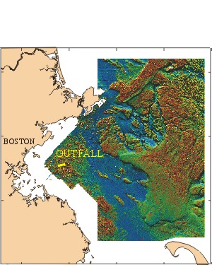
Boston Harbor, once one of the most polluted waterways in the nation, is in the
final stages of a major cleanup. A $3.8 billion cleanup program, begun
in 1985 by the Massachusetts Water Resources Authority (MWRA) was designed
to address more than 300 years of metropolitan waste disposal. The cleanup
has significantly improved the environmental quality of the harbor, enforced
reduction of industrial waste releases at the source, eliminated sludge
discharge (Dec. 1991), improved treatment of Boston sewage, and relocated
the sewage outfall from the Harbor mouth to a new location 9 miles
offshore in Massachusetts Bay.
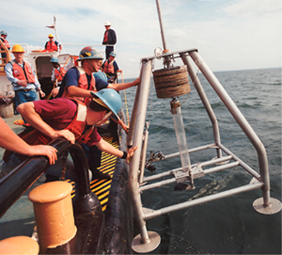
Since 1989, the United
States Geological Survey (USGS), in cooperation with the MWRA, has been
conducting research to understand and predict the fate of contaminants
introduced to Massachusetts` coastal waters. The overall objective
is to develop a capability to predict the fate of contaminants associated
with fine-grained sediments on a regional basis. We emphasize sediments
because most contaminants introduced to the ocean are adsorbed by and
transported with suspended sediments. After complicated cycles of deposition,
resuspension, and biological and chemical interactions, contaminants on
particles may be eventually buried in bottom sediments, which become the
ultimate contaminant sink.
 |
The ultimate
respositories for some of the contaminants introduced from
the Boston Metropolitan area are Stellwagen Basin and Cape Cod Bay.
Winter
storms resuspend and transport sediments from the region offshore
of Boston, including the new outfall site, to these locations. Maps
of sedimentary environments and bottom morphology have been
generated using side scan sonar and high resolution bathymetric surveys.
These have helped managers choose the location of the outfall and
the location
of stations used to monitor the fate and transport of contaminants. |
|
|
Monitoring sites have been established at critical locations
in Massachusetts Bay to establish a baseline of contaminant levels
in sediments and to document natural variability. These sites will
continue to be monitored over the next 2 years as the treated effluent
is discharged through the new outfall into Massachusetts Bay. Since
1989, monitoring
oceanographic parameters and sediment chemistry by the USGS
near the Massachusetts Bay outfall has identified storms
as a major process for redistributing sediments and associated contaminants.
The USGS research program complements the benthic and water column
monitoring program conducted by the Massachusetts
Water Resources Authority.
|
|