Jump to main content.


Kansas

Use the state map or Places Involving this State watershed links below to zoom in to find more information about your watershed.
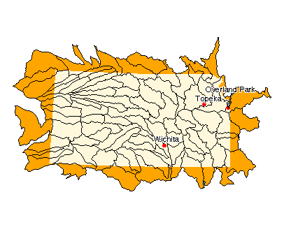
Image of State

State Profile
Find general information integrated for this specific state

Assessments of Watershed Health

Environmental Information

Air Pollution Data (Provided by Office of Air Quality Planning and Standards)

Beach Monitoring Sites

Bioassessment Projects

Drinking Water Information (Source: EPA's Office of Ground Water & Drinking Water)

Environmental Websites

Federal and State Government Regulation and Program References

National Priorities List Sites

Section 319 Success Stories (Source: EPA's 319 Grant Program)

Volunteer Monitoring Efforts for Kansas

Watershed Groups for this State (Provided by Adopt Your Watershed)


Information provided by United States Geological Survey (USGS) Exit EPA Disclaimer

Science in Your State
Water Resources
Real-time Streamflow Data
Fact Sheets

Places Involving this State

Watersheds: 90
Counties: 105
American Heritage Rivers: 0
National Estuary Programs: 0
EPA Regional Office

The following sites exit the EPA Website Exit EPA Disclaimer

Agriculture Statistics Service (USDA)

Energy Data (DOE)

Natural Resources Conservation Service (USDA)

State and Local Government on the Net

State Government

USDA State Fact Sheet (Source USDA Economic Research Service)

10240005, Tarkio-Wolf 10240007, South Fork Big Nemaha 10240008, Big Nemaha 10240011, Independence-Sugar 10250001, Arikaree 10250002, North Fork Republican 10250003, South Fork Republican 10250004, Upper Republican 10250009, Harlan County Reservoir 10250010, Upper Sappa 10250011, Lower Sappa 10250012, South Fork Beaver 10250013, Little Beaver 10250014, Beaver 10250015, Prairie Dog 10250016, Middle Republican 10250017, Lower Republican 10260001, Smoky Hill Headwaters 10260002, North Fork Smoky Hill 10260003, Upper Smoky Hill 10260004, Ladder 10260005, Hackberry 10260006, Middle Smoky Hill 10260007, Big 10260008, Lower Smoky Hill 10260009, Upper Saline 10260010, Lower Saline 10260011, Upper North Fork Solomon 10260012, Lower North Fork Solomon 10260013, Upper South Fork Solomon 10260014, Lower South Fork Solomon 10260015, Solomon 10270101, Upper Kansas 10270102, Middle Kansas 10270103, Delaware 10270104, Lower Kansas 10270205, Lower Big Blue 10270206, Upper Little Blue 10270207, Lower Little Blue 10290101, Upper Marais Des Cygnes 10290102, Lower Marais Des Cygnes 10290103, Little Osage 10290104, Marmaton 10290108, South Grand 10300101, Lower Missouri-Crooked 11020009, Upper Arkansas-John Martin 11030001, Middle Arkansas-Lake Mckinney 11030002, Whitewoman 11030003, Arkansas-Dodge City 11030004, Coon-Pickerel 11030005, Pawnee 11030006, Buckner 11030007, Upper Walnut Creek 11030008, Lower Walnut Creek 11030009, Rattlesnake 11030010, Gar-Peace 11030011, Cow 11030012, Little Arkansas 11030013, Middle Arkansas-Slate 11030014, North Fork Ninnescah 11030015, South Fork Ninnescah 11030016, Ninnescah 11030017, Upper Walnut River 11030018, Lower Walnut River 11040002, Upper Cimarron 11040003, North Fork Cimarron 11040004, Sand Arroyo 11040005, Bear 11040006, Upper Cimarron-Liberal 11040007, Crooked 11040008, Upper Cimarron-Bluff 11050001, Lower Cimarron-Eagle Chief 11060001, Kaw Lake 11060002, Upper Salt Fork Arkansas 11060003, Medicine Lodge 11060004, Lower Salt Fork Arkansas 11060005, Chikaskia 11070101, Upper Verdigris 11070102, Fall 11070103, Middle Verdigris 11070104, Elk 11070106, Caney 11070201, Neosho Headwaters 11070202, Upper Cottonwood 11070203, Lower Cottonwood 11070204, Upper Neosho 11070205, Middle Neosho 11070206, Lake O' The Cherokees 11070207, Spring 11100102, Middle Beaver

Disclaimer | Comments


Local Navigation


Jump to main content.