In the 2012 President's Budget Request, the National Biological Information Infrastructure (NBII) is terminated. As a result, all resources, databases, tools, and applications within this web site will be removed on January 15, 2012. For more information, please refer to the NBII Program Termination page.
The Protected Areas Database of the United States (PAD-US) is a national database of federal and state conservation lands. It contains the most current information about publicly held conservation lands (with conservation measures available) in the U.S. It was first published for delivery to the UNEP-World Conservation Monitoring Center's (WCMC) World Database for Protected Areas (WDPA) in April 2009 by USGS GAP, on behalf of the PAD-US Partnership.
The Northwest Regional GAP Analysis Project (NWGAP) is an update of the Gap Analysis Program's mapping and assessment of biodiversity for the five-state region encompassing Washington, Idaho, Oregon, Montana, and Wyoming. It is a multi-institutional cooperative effort coordinated by the U.S. Geological Survey Gap Analysis Program. Data sets are made available to the public by the NWGAP consortium of institutions responsible for their development.
The following resources and datasets have been developed as part of the NWGAP Project:
Want to explore GAP data for the Northwest?
Click here or scroll below to directly explore the new interactive map viewers for the US, including the GAP National Landcover Viewer, the Protected Areas Viewer, and the GAP Online Analysis Tool.
Need NWGAP data and information?
Click on one of the links below to access NWGAP data in your category of interest.
Click on the tabs above to explore our map viewers.
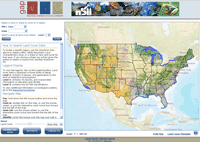
Land cover viewer:
The Gap Analysis Program (GAP) national land cover viewer displays data on the vegetation and land use patterns of the continental United States. It combines land cover data generated for the Southwest Regional Gap Analysis project completed in 2004, the Southeast Regional Gap Analysis Project completed in 2007, the Northwest Regional Gap project, and the updated California Gap project completed in 2009. For areas of the country without an Ecological System level Gap project, data created by the Landfire Project was used. All these projects use consistent base satellite imagery, the same classification systems and similar mapping methodology allowing for the creation of a seamless national land cover map.
Protected Areas of the United States viewer:
The Protected Areas Database of the United States (PAD-US) is a national database of federal and state conservation lands. It contains the most current information about publicly held conservation lands (with conservation measures available) in the U.S. It was first published for delivery to the UNEP-World Conservation Monitoring Center's (WCMC) World Database for Protected Areas (WDPA) in April 2009 by USGS GAP, on behalf of the PAD-US Partnership.
GAP Online Analysis Tool:
This open-source mapping application allows users to explore and interact with GAP datasets by providing: the ability to selecte an area of interest; the ability to select a single or set of species; access to quantitative tools to summarize land cover, predicted habitat or protection status; and the ability to generate reports.
How is GAP Analysis Conducted?
"Gap Analysis" provides a scientific method for identifying the representation of native species in our present-day network of conservation lands. Four major steps are completed in the GAP Analysis process:
1. Land Cover Dataset: Map land cover of the dominant plant species.
2. Animal Habitat Models: Map predicted distributions of vertebrate species.
3. Land Stewardship Dataset: Delineate land stewardship at one of four levels.
4. Identify the "gaps!": Analyze the representation of vertebrate species and vegetation alliances in conservation lands.
Images: Southwest Regional GAP Analysis Project


![NWGAP Logo [Image: Northwest Regional GAP Analysis Project]](https://cybercemetery.unt.edu/archive/nbii/20120114061628im_/http://www.nbii.gov/portal/server.pt/gateway/PTARGS_0_2_25638_1923_7084_43/http%3B/cbi-lap7.cbi.cr.usgs.gov%3B7097/publishedcontent/publish/geographic/southwest/pnwin_nwgap_intro/pnwin_nwgap_intro_3.jpg)
 The Gap Analysis Program (GAP) national land cover viewer displays data on the vegetation and land use patterns of the continental United States. It combines land cover data generated for the Southwest Regional Gap Analysis project completed in 2004, the Southeast Regional Gap Analysis Project completed in 2007, the Northwest Regional Gap project, and the updated California Gap project completed in 2009. For areas of the country without an Ecological System level Gap project, data created by the Landfire Project was used. All these projects use consistent base satellite imagery, the same classification systems and similar mapping methodology allowing for the creation of a seamless national land cover map.
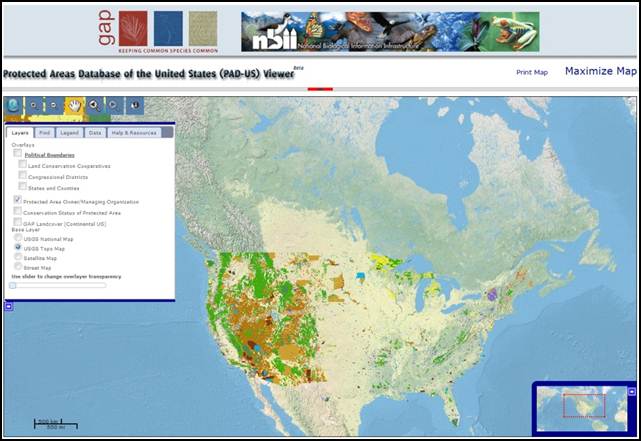 The Protected Areas Database of the United States (PAD-US) is a national database of federal and state conservation lands. It contains the most current information about publicly held conservation lands (with conservation measures available) in the U.S. It was first published for delivery to the UNEP-World Conservation Monitoring Center's (WCMC) World Database for Protected Areas (WDPA) in April 2009 by USGS GAP, on behalf of the PAD-US Partnership.
 This open-source mapping application allows users to explore and interact with GAP datasets by providing: the ability to selecte an area of interest; the ability to select a single or set of species; access to quantitative tools to summarize land cover, predicted habitat or protection status; and the ability to generate reports.


