Northern Rocky Mountain Science Center (NOROCK)
Home | About Us | Science | Product Library | News & Events | Staff | Students | Partners | Contact Us
Northern Rocky Mountain Science Center (NOROCK)
Home | About Us | Science | Product Library | News & Events | Staff | Students | Partners | Contact Us
 |
|
|
Glaciers re-photographed by USGS since 1997 |
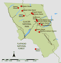 |
| Click on map for larger version. The red dots on this map represent selected repeat photographs of glaciers taken throughout Glacier National Park, Montana. |
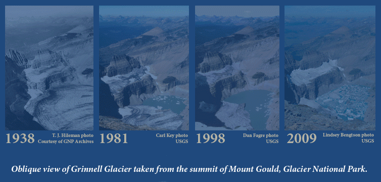
Climate change research in Glacier National Park, Montana entails many methods of documenting the landscape change, including the decline of the parks namesake glaciers. While less quantitative than other high-tech methods of recording glacial mass, depth, and rate of retreat, repeat photography has become a valuable tool for communicating effects of global warming. With evidence of worldwide glacial recession and modeled predictions that all of the parks glaciers will melt by the year 2030, USGS scientists have begun the task of documenting glacial decline through photography. The striking images created by pairing historic images with contemporary photos has given global warming a face and made climate change a relevant issue to viewers. The images are an effective visual means to help viewers understand that climate change contributes to the dynamic landscape changes so evident in Glacier National Park.
The Repeat Photography Project began in 1997 with a systematic search of the archives at Glacier National Park. We began searching for historic photographs of glaciers in the vast collection that spans over a century. Many high quality photographs exist from the parks early photographers such as Morton Elrod, T.J. Hileman, Ted Marble, F.E. Matthes, and others who scoured the park to publicize its beauty and earn their livings. Copies of the historic photos were taken in the field to help determine the exact location of the original photograph. Photographing the glaciers cannot occur until the previous winters snow has melted on the glacial ice and when air quality conditions are considered at least good. This creates a narrow window in the northern clime of Glacier National Park where smoke from forest fires prevented photography on many occasions in the past few years. Since 1997 over sixty photographs have been repeated of seventeen different glaciers. Thirteen of those glaciers have shown marked recession and some of the more intensely studied glaciers have proved to be just 1/3 of their estimated maximum size that occurred at the end of the Little Ice Age (circa 1850). In fact, only 26 named glaciers presently exist of the 150 glaciers present in 1850 and those that do are mere remnants of their previous size. Other glaciers, such as Piegan Glacier, have remained visibly unchanged as a result of their north- northeast aspect and tendency to accumulate wind deposited snow along the Continental Divide. The photos of Piegan Glacier though, record dramatic change in foreground vegetation in response to climate change factors such as change in wildfire frequency and infestation of white pine blister rust. Close inspection of the photo pairs in this collection reveal many changes on a more subtle level than the obvious size reduction in glacial ice see what changes you can detect.

Glaciers
Agassiz (Boulder Pass)
Agassiz - terminus
Blackfoot-Jackson NEW
Boulder
Boulder - Ice Cave
Boulder - Chapman Peak
Chaney - terminus
Chaney - notch
Clements NEW
Grant
Grinnell - trail 1900-2008
Grinnell - trail 1910-2008
Grinnell - trail 1911-2008
Grinnell Footbridge 87-08
Grinnell Footbridge 20-08
Grinnell Lake Josephine
Grinnell Quad-Mt. Gould NEW
Grinnell-Overlook
Grinnell-Mather Overlook
Grinnell-N Moraine
Grinnell-N Part Moraine
Grinnell-S Moraine
Grinnell-Elrod's Rock
Grinnell Terminus
Grinnell Basin 1936-2010 NEW
Jackson NEW
Piegan - Siyeh
Red Eagle - Logan NEW
Sexton
Shepard
Sperry
Sperry - Panorama
Sperry - Mid view
Swiftcurrent - trail
Swiftcurrent - lookout
Thunderbird
Vegetation
Hidden Lake (a) NEW
Hidden Lake (b) NEW
Piegan NEW
Sperry - NE view
Repeat Photo Sets
PPT - all pairs
PDF - all pairs
Posters
Return to Repeat Photo Home
Field Photo Gallery
Contact:
Daniel Fagre, PhD
Research Ecologist
West Glacier, MT
Phone: 406-888-7922
Email: dan_fagre@usgs.gov
Many Glacier Hotel
Exhibit site
Click on image for Gallery Guide
Research Areas
Glacier Research
Snow and Avalanche Research
Mountain Ecosystems
Landscape Change Photography
Alpine Climatology
Western Mountain Initiative
Product Library
Publications
Presentations
Glacier Recession Animation
Flattop SNOTEL Graphs
Repeat Photo Posters
Info Sheets
Photo Galleries
Repeat Photography
Panoramic Photography
Gigapixel Photography
Field Research
CCME Staff
Dan Fagre
Lisa McKeon
Blase Reardon
Lindsey Bengtson
Erich Peitzsch
Greg Pederson
Contact CCME
CCME
Glacier National Park
West Galcier, MT 59936