United States Department of Agriculture
Natural Resources Conservation Service
National Water and Climate Center Go to Accessibility Information
Skip to Page Content
National Water and Climate Center
  

Montana SNOTEL Sites

For individual sites, choose from the list, or select from the map below.

Montana SNOTEL Map Hawkins Lake (516) Garver Creek (918) Banfield Mountain (311) Stahl Peak (787) Grave Creek (500) Poorman Creek (932) Hand Creek (510) Emery Creek (469) Noisy Basin (664) Flattop Mtn (482) Many Glacier (613) Pike Creek (693) Badger Pass (307) Dupuyer Creek (458) Rocky Boy (917) Hoodoo Basin (530) Sleeping Woman (783) Bisson Creek (346) Moss Peak (646) Kraft Creek (562) North Fork Jocko (667) Mount Lockhart (649) Waldron (847) Wood Creek (876) Copper Camp (414) Copper Bottom (413) Stuart Mountain (901) Lubrecht Flume (604) N Fk Elk Creek (657) Combination (410) Black Pine (349) Skalkaho Summit (760) Daly Creek (433) Twin Lakes (836) Twelvemile Creek (835) Warm Springs (850) Peterson Meadows (930) Barker Lakes (313) Calvert Creek (381) Nevada Ridge (903) Frohner Meadows (487) Rocker Peak (722) Tizer Basin (893) Deadman Creek (437) Daisy Peak (919) Crystal Lake (427) Nez Perce Camp (662) Saddle Mtn. (727) Darkhorse Lake (436) Bloody Dick (355) Lemhi Ridge (576) Mule Creek (656) Basin Creek (315) Albro Lake (916) Lower Twin (603) Clover Meadow (403) Short Creek (753) Lone Mountain (590) Porcupine (700) S Fork Shields (725) Lick Creek (578) Shower Falls (754) Beagel Springs (318) Divide (448) Tepee Creek (813) Lakeview Ridge (568) Black Bear (347) Madison Plateau (609) Whiskey Creek (858) West Yellowstone (924) Beaver Creek (328) Carrot Basin (385) Cole Creek (407) Placer Basin (696) Box Canyon (363) Monument Peak (635) Fisher Creek (480) Northeast Entrance (670) White Mill (862) Spur Park (781) Onion Park (1008) Stringer Creek (1009) Burnt Mtn. (981) Elk Peak (1106) East Boulder Mine (1105) Boulder Mountain (360) Pickfoot Creek (690) Sacajawea (929) Brackett Creek (365) Blacktail Mtn (1144) Ashley Divide (1165)

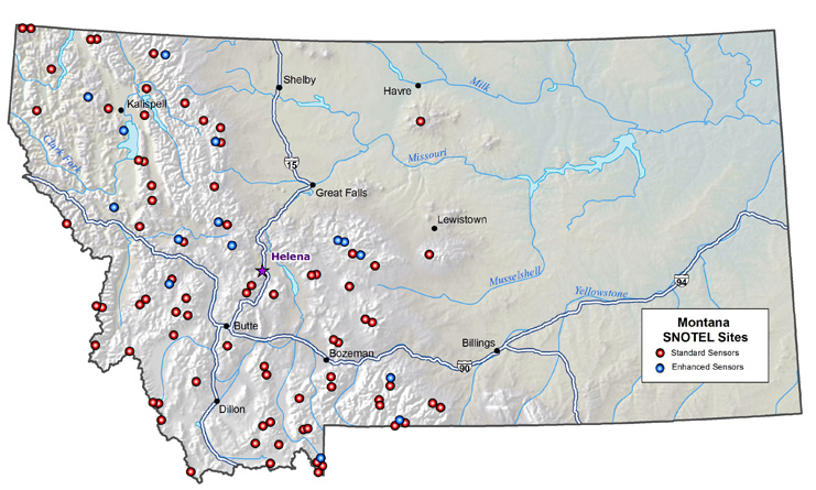
Standard sensors include snow water equivalent, precipitation and temperature. Enhanced sensors may include any or all of following: soil moisture, soil temperature, wind speed/direction, solar radiation, humidity, precipitation (tipping bucket rain gage), or barometric pressure.

The data provided for this state are provisional and may be subject to future revisions. Data may not be readily available for all sites shown on the map. Contact the state Snow Survey and Water Supply Forecasting specialist shown below for further information.

Water Supply Specialist:
Brian Domonkos
NRCS, USDA
Federal Building, Room 443, 10 E. Babcock
Bozeman, MT 59715
(406) 587-6991
Brian.Domonkos@mt.usda.gov

< Back to Map Based SNOTEL Page