In the 2012 President's Budget Request, the National Biological Information Infrastructure (NBII) is terminated. As a result, all resources, databases, tools, and applications within this web site will be removed on January 15, 2012. For more information, please refer to the NBII Program Termination page.
NOTE: To view a sublayer, the corresponding parent layer must also be selected. Only the topmost layer will be visible at all times.
Plus symbols (
) and downward arrows (
) indicate that more information is available. Please click on them to expand the information.
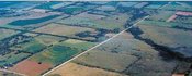
STEP 1:
Launch the mapping application by clicking on any ecoregion.
STEP 2:
Select a T&E or Invasive species of interest in the mapping application to view the spatial distribution of the species.
NOTE: If the (*) symbol follows a species name this indicates that additional information is available for that species.
STEP 3:
Uncheck the species distribution layer, and select an environmental parameter of interest (average temperature, average precipitation, land use/land cover, etc) to investigate relationships between species distributions and environmental variables.
Explore NBII Ecoregions
There are incredibly diverse ecoregions throughout the NBII, each featuring unique habitats, species and biodiversity. Explore other areas of biodiversity:
Ecoregions of the Southwest and Central Southwest Gulf Coast
There are twelve different Level 2 (as designated by the EPA) ecoregions within the Southwest and Central Southwest Gulf Coast regions. For each ecoregion, an informational page describing the unique physical and biological characteristics that comprise the region has been developed. The discussion highlights one federally designated endangered species, one invasive species and one species typical to that ecoregion.
The associated interactive mapping application provides access to county-by-county distribution of all federally-designated threatened and endangered species within the Southwest (SWIN) and Central Southwest Gulf Coast Information Node (CSWGCIN) ecoregions. Additionally, the application provides access to the geographic distribution of selected invasive species, political boundaries, and baseline environmental data such as average temperature and average precipitation. Click on the ecoregion map below to start exploring the rich biodiversity in SWIN and CSWGCIN.
An ecoregion is a land area defined by ecological and geographical boundaries. Ecoregions are delineated according to their common physical environment (soil, climate, landforms) and biological characteristics (plant and animal communities).
Ecoregions are a type of spatial classification tool used by scientists, resources managers, and conservation organizations to regionalize biogeographic areas. This regionalization is done to organize complex natural systems into discrete units with boundaries.
Ecoregion boundaries indicate a change in the physical environment and ecological structure of a geographic area. While the changes may occur abruptly, change can also be gradual. Therefore, it is important to remember that ecoregion boundaries are approximations of areas of biogeographic change.
Ecoregion Classification
Ecoregion classifications are used to facilitate analyses of biological diversity and assist habitat conservation planning efforts. This type of classification aids management efforts because it facilitates coordination across geopolitical borders (county, city, state, and national). There are a number of different types of ecoregion classification systems that have been created by various management organizations (e.g. the Bailey/ US Forest Service system, the Omernik/US EPA classification, and the World Wildlife Fund classification system). The ecoregion classifications differ in the delineation methods and application. This portal uses the Omernik/US EPA ecoregion classification system.
Classification System
Ecoregions are initially grouped broadly (Level 1), and from there are broken down into more narrow ecological assemblages (Levels 2-4). There are 15 Level 1 ecoregions in North America which delineate the major ecological zones within the continent. These 15 ecoregions are further broken down into 52 Level 2 ecoregions which highlight ecological diversity at the sub-continent level. There are approximately 200 Level 3 ecoregions in North America which describe the physical and ecological characteristics of an area at a regional scale. Level 4 ecoregions are the most narrow and describe ecological assemblages at a localized level.