Jump to main content.


Alaska

Use the state map or Places Involving this State watershed links below to zoom in to find more information about your watershed.
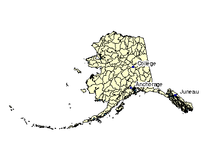
Image of State

State Profile
Find general information integrated for this specific state

Assessments of Watershed Health

Environmental Information

Air Pollution Data (Provided by Office of Air Quality Planning and Standards)

Beach Monitoring Sites

Bioassessment Projects

Drinking Water Information (Source: EPA's Office of Ground Water & Drinking Water)

Environmental Websites

Federal and State Government Regulation and Program References

National Priorities List Sites

Section 319 Success Stories (Source: EPA's 319 Grant Program)

Volunteer Monitoring Efforts for Alaska

Watershed Groups for this State (Provided by Adopt Your Watershed)


Information provided by United States Geological Survey (USGS) Exit EPA Disclaimer

Science in Your State
Water Resources
Real-time Streamflow Data
Fact Sheets

Places Involving this State

Watersheds: 136
Counties: 25
American Heritage Rivers: 0
National Estuary Programs: 0
EPA Regional Office

The following sites exit the EPA Website Exit EPA Disclaimer

Agriculture Statistics Service (USDA)

Energy Data (DOE)

Natural Resources Conservation Service (USDA)

State and Local Government on the Net

State Government

USDA State Fact Sheet (Source USDA Economic Research Service)

19010101, Southeast Mainland 19010102, Ketchikan 19010102, Ketchikan 19010102, Ketchikan 19010103, Prince Of Wales 19010103, Prince Of Wales 19010103, Prince Of Wales 19010201, Mainland 19010202, Kuiu-Kupreanof-Mitkof-Etolin-Zarembo-Wrang 19010202, Kuiu-Kupreanof-Mitkof-Etolin-Zarembo-Wrang 19010202, Kuiu-Kupreanof-Mitkof-Etolin-Zarembo-Wrang 19010202, Kuiu-Kupreanof-Mitkof-Etolin-Zarembo-Wrang 19010202, Kuiu-Kupreanof-Mitkof-Etolin-Zarembo-Wrang 19010202, Kuiu-Kupreanof-Mitkof-Etolin-Zarembo-Wrang 19010203, Baranof-Chichagof Islands 19010203, Baranof-Chichagof Islands 19010301, Lynn Canal 19010301, Lynn Canal 19010302, Glacier Bay 19010303, Chilkat-Skagway Rivers 19010303, Chilkat-Skagway Rivers 19010401, Yakutat Bay 19010402, Bering Glacier 19020101, Upper Copper River 19020102, Middle Copper River 19020103, Chitina River 19020104, Lower Copper River 19020104, Lower Copper River 19020201, Eastern Prince William Sound 19020201, Eastern Prince William Sound 19020202, Western Prince William Sound 19020202, Western Prince William Sound 19020301, Lower Kenai Peninsula 19020302, Upper Kenai Peninsula 19020402, Matanuska 19020501, Upper Susitna River 19020502, Chulitna River 19020503, Talkeetna River 19020504, Yentna River 19020505, Lower Susitna River 19020601, Redoubt-Trading Bays 19020602, Tuxdeni-Kamishak Bays 19020701, Kodiak-Afognak Islands 19020701, Kodiak-Afognak Islands 19020701, Kodiak-Afognak Islands 19020702, Shelikof Straight 19030101, Cold Bay 19030101, Cold Bay 19030102, Fox Islands 19030102, Fox Islands 19030102, Fox Islands 19030102, Fox Islands 19030103, Western Aleutian Islands 19030103, Western Aleutian Islands 19030103, Western Aleutian Islands 19030103, Western Aleutian Islands 19030103, Western Aleutian Islands 19030201, Port Heiden 19030202, Ugashik Bay 19030203, Egegik Bay 19030204, Naknek 19030205, Lake Clark 19030206, Lake Iliamna 19030301, Upper Nushagak River 19030302, Mulchatna River 19030303, Lower Nushagak River 19030304, Wood River 19030305, Togiak 19030401, North Fork Kuskokwim River 19030402, Farewell Lake 19030403, Takotna River 19030404, Holitna River 19030405, Stony River 19030501, Aniak 19030502, Kuskokwim Delta 19030503, Nunavak-St.Matthew Islands 19040101, White River 19040102, Ladue River 19040103, Sixtymile River 19040104, Fortymile River 19040201, Old Crow River 19040202, Coleen River 19040203, Sheenjek River 19040204, Black River 19040205, Porcupine Flats 19040301, Middle Fork-North Fork Chandalar Rivers 19040302, East Fork Chandalar River 19040303, Christian River 19040304, Lower Chandalar River 19040401, Eagle To Circle 19040402, Birch-Beaver Creeks 19040403, Yukon Flats 19040404, Ramparts 19040501, Nebesna-Chisana Rivers 19040502, Tok 19040503, Healy Lake 19040504, Delta River 19040505, Salcha River 19040506, Chena River 19040507, Tanana Flats 19040508, Nenana River 19040509, Tolovana River 19040510, Kantishna River 19040511, Lower Tanana River 19040601, Upper Koyukuk River 19040602, South Fork Koyukuk River 19040603, Alatna River 19040604, Kanuti River 19040605, Allakaket 19040606, Huslia River 19040607, Dulbi River 19040608, Koyukuk Flats 19040609, Kateel River 19040701, Tozitna River 19040702, Nowitna River 19040703, Melozitna River 19040704, Ramparts To Ruby 19040705, Galena 19040801, Anvik River 19040802, Upper Innoko River 19040803, Lower Innoko River 19040804, Anvik To Pilot Station 19040805, Yukon Delta 19040805, Yukon Delta 19040805, Yukon Delta 19040805, Yukon Delta 19040805, Yukon Delta 19040805, Yukon Delta 19050101, St. Lawrence Island 19050102, Unalakleet 19050103, Norton Bay 19050104, Nome 19050105, Imuruk Basin 19050201, Shishmaref 19050202, Goodhope-Spafarief Bay 19050203, Buckland River 19050301, Selawik Lake 19050302, Upper Kobuk River 19050303, Middle Kobuk River 19050304, Lower Kobuk River 19050401, Upper Noatak River 19050402, Middle Noatak River 19050403, Lower Noatak River 19050404, Wulik-Kivalina Rivers 19050405, Lisburne Peninsula 19060101, Kukpowruk River 19060102, Kokolik River 19060103, Utukok River 19060201, Kuk River 19060202, Northwest Coast 19060203, Meade River 19060204, Ikpikpuk River 19060205, Harrison Bay 19060301, Upper Colville River 19060302, Killik River 19060303, Chandler-Anaktuvuk Rivers 19060304, Lower Colville River 19060401, Kuparuk River 19060402, Sagavanirktok River 19060403, Mikkelson Bay 19060501, Canning River 19060502, Camden Bay 19060503, Beaufort Lagoon

Disclaimer | Comments


Local Navigation


Jump to main content.