

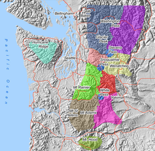
Mouse over an area for a quick glance of expected danger levels.
Click on an area for the integrated text and graphic forecast product.
The Avalanche Danger Rose
The danger rose represents the highest danger level(s) expected for the indicated area (by elevation and aspect) for the daylight hours. Danger roses for two days will normally be shown for each forecast area on mouse-over of the particular shaded zone.
The danger trend arrow (lower left part of rose graphic) indicates the most significant (highest impact) avalanche danger change expected for the daylight hours, ranging from strongly increasing (arrow pointing up) to strongly decreasing (arrow pointing down). Although the danger rose figures only indicate the greatest danger for the particular region for the daylight hours, danger trends for overnight hours are discussed in the text product.
The danger rose can be visualized as a conical mountain within the forecast area that is divided into elevation rings and aspect slices as shown in the example. The first sample rose shown below with the mountain indicaes an avalanche warning along with a strongly increasing danger trend and high danger above 4000 feet.

Danger Rose Example:

The rose to the left indicates two danger levels between 3000 ft (the outermost ring) and 7000 ft (the innermost ring). These dangers…moderate in yellow and considerable in orange…indicate the following danger description:
Considerable avalanche danger on northwest through northeast exposures above 4000 feet, otherwise moderate avalanche danger below 7000 feet. The slightly upward angled arrow in the left lower part of the figure indicates the most significant danger trend is for a slight danger increase during the day.
Danger Scale Legend
|
|
= Extreme avalanche danger | |
|
|
= High avalanche danger | |
|
|
= Considerable avalanche danger | |
|
|
= Moderate avalanche danger | |
|
|
= Low avalanche danger | |
Warning = Extreme or high avalanche danger occurring or expected to occur within 12 hours: at or below 4000 feet in the Olympics and/or WA Cascades; at or below 5000 feet in the Mt. Hood Area.
Watch = Warning conditions expected within 12-48 hours.
Special Conditions = Unusual conditions meriting special attention that do not meet Watch or Warning criteria.
Click here for complete definitions of the avalanche danger scale.