Water and Climate Information
Water Supply
Climate Monitoring
Climate Interpretation
|
| |
SNOTEL Data & Products
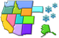 |
SNOTEL Map Interface
Map-based access to data from individual SNOTEL sites. Includes
all available sensors.
Click on a state from the map or select from the list below:
|
 |
General SNOTEL information, site lists, fact sheets, and
more...
|
 |
Snow Depth*
Products
|
 |
All Sensors
Data |
Products
Includes SWE, precipitation, temperature, snow depth* and soil
moisture/temperature data*.
|
 |
Precipitation
Data |
Products
|
 |
Snow Water Equivalent
Data |
Products
|
 |
Temperature
Data |
Products
|
*
Soil moisture/temperature and snow depth data are only available at select SNOTEL
sites.
|
All data
contained herein are provisional and subject to revision.
|
|