


www.nnvl.noaa.gov
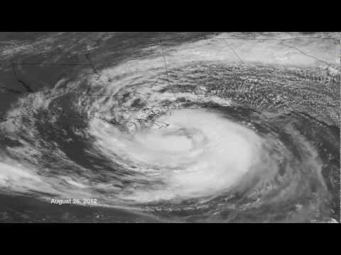 GOES-14 has been placed in Super Rapid Scan Mode to support research and development efforts on the next generation of geostationary satellites. This movie shows the visible channel one minute imagery of Isaac from August 24 through landfall on August 28 into August 29, 2012.
Isaac Now, Katrina Then
August 30, 2012

Flooded ninth ward after Hurricane Katrina
[Click image to enlarge]
As the country watches the warnings and vivid satellite images of Hurricane Isaac moving through the U.S. Gulf Coast, most have a sense of Déjá Vu. That's because seven years ago on August 29th, America watched for what became known as one of the strongest storms to impact the United States. We watched for Hurricane Katrina; the storm that changed the face of New Orleans and our perceptions of hazardous weather for years to come.
Scientist from NOAA's National Climatic Data Center indicated that Hurricane Katrina hit America's shores with an impact not experienced in more than 100 years. Her sustained winds of 125 mph or 110 knots, characterized Katrina as a Category 3 Hurricane according to the Saffir-Simpson scale.
Katrina's Chronicle

Gulf Coast after Hurricane Katrina
[Click image to enlarge]
Katrina caused widespread devastation along the central Gulf Coast states of the U.S. and cities such as New Orleans, LA, Mobile, AL, and Gulfport, MS were forever changed. These cities bore the brunt of Katrina's force and needed months and years of recovery efforts to restore daily normal living to local citizens.
Breaks in the levees that separate New Orleans from surrounding lakes resulted in high loss of life and property damage. The Lake Pontchartrain levee failures contributed to widespread flooding impacting more that 80 percent of New Orleans.
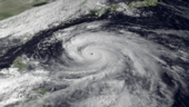
Isaac's Trek

Hurricane Isaac
[Click image to enlarge]
As Isaac moves over the same region, NOAA is prepared to support the Nation with daily weather forecasts, and severe storm warnings. The recently launched Hurricane Central 2012 is a NOAA "one-stop source" for tropical cyclone news and information tracking Isaac. The site provides links to NOAA and government sites for forecasts, advisories, radar images, fact sheets, links to preparedness resources, and more on a comprehensive webpage.
Environmental Satellites - Watching Our Weather
Using environmental satellites to observe the Earth from space is one of the key tools in forecasting weather, analyzing climate, and monitoring hazards worldwide. NESDIS manages a system of satellites providing 24-hour coverage with a never-ending stream of information critical for making decisions affecting responses to hazardous weather. NESDIS also provides information resources through the web and social media to keep the public well-versed of any environmental events that could affect daily life.
As Hurricane Katrina is remembered, look forward and utilize the advanced tools currently available from NOAA and other first responders to help mitigate severe storm challenges. From Hurricanes Katrina to Isaac and those in between, NOAA and NESDIS will continue to work with citizens and governments to help them make key decisions for preserving and restoring homes, cities, and the coastlines of our Nation from the affects of hazardous weather outbreaks.
----