Science Features
On August 23, 2011, tens of millions of people in the eastern U.S. and southeastern Canada were startled by sudden ground shaking from a rare, magnitude 5.8 earthquake in central Virginia. Several small earthquakes occur every month in the eastern U.S., but this earthquake was among the largest to occur in this region in the last century.
It is estimated that approximately one third of the U.S. population could have felt this earthquake, more than any other earthquake in U.S. history. Around 148,000 people reported their ground-shaking experiences caused by the earthquake on the USGS “Did You Feel It?” website. Shaking reports came from southeastern Canada to Florida and westward to locations near the Mississippi River.
Start with Science
There is much still unknown about the earthquake, including details of the fault that produced it and possible relationships to older faults and other geologic features. Although it was a rare event for the east coast, the earthquake was not a surprise, in that it occurred within the Central Virginia seismic zone. This zone has been identified on USGS seismic hazard maps for decades as an area of elevated earthquake risk. However, it is the largest known earthquake to have occurred in that zone.
“Every large earthquake is a learning experience, but it is particularly the case for this Virginia earthquake because of the rarity of such events in the eastern U.S.,” said USGS Director Marcia McNutt. “For example, what are we doing so right that a record setting number of east coast residents know the value to science of submitting their experiences on ‘Did You Feel It?,’ and yet not enough appropriately responded with ‘duck and cover’ during the seconds of most intense ground shaking?”

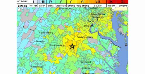
USGS “Did You Feel It?” data, showing reports from the public on feeling the magnitude 5.8 earthquake on August 23, 2011 in central Virginia.
Further studies to better understand this earthquake will help ensure public safety in Virginia and other areas of the eastern U.S.
The USGS is actively involved in studying last year’s earthquake in Virginia, as well as earthquake hazards worldwide. The President’s requested FY13 budget includes a proposed increase in funding to expand USGS efforts to assess eastern U.S. earthquake hazards. USGS expertise includes earthquake monitoring and notification, earthquake impact and hazard assessments, geologic mapping and targeted research on earthquake causes and effects.
So what have scientists been up to? Take a glimpse below at some new insights and projects currently underway.
Rapid Response to Record Aftershocks
Since the earthquake, more than 450 aftershocks have been recorded. These events were calculated based on analysis by the USGS National Earthquake Information Center (NEIC) using data from portable seismographs that were deployed by several organizations immediately after the earthquake.
“The speed with which the USGS and our state and university partners got networks of seismometers into the field to capture the aftershock sequence from this earthquake defined the causative fault at depth, a first for a major eastern US earthquake,” said McNutt. “Unlike the typical situation in the western U.S., faults in this part of the country do not have a surface expression, making it far more difficult to estimate the maximum possible magnitude of earthquake that the fault can generate or the expected repeat time of the earthquakes.”

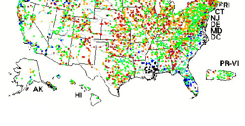
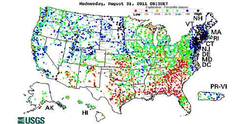
This image illustrates how earthquakes are felt over much larger areas in the eastern United States than those west of the Rocky Mountains. USGS “Did You Feel It?” data from the magnitude 5.8 earthquake on August 23, 2011 in central Virginia (green) and from one of similar magnitude and depth in California (red).
This careful effort has produced the best recorded aftershock sequence in the eastern U.S. A complete catalog of the number, size and timing of all the aftershocks is being compiled. Aftershock monitoring is valuable for locating and characterizing the dimensions of the causative fault, recording data useful for ground-motion investigations, and characterizing the aftershock-sequence.
View a map of the aftershocks and watch a time lapse video of the aftershock sequence.
Damage Assessments and Impacts
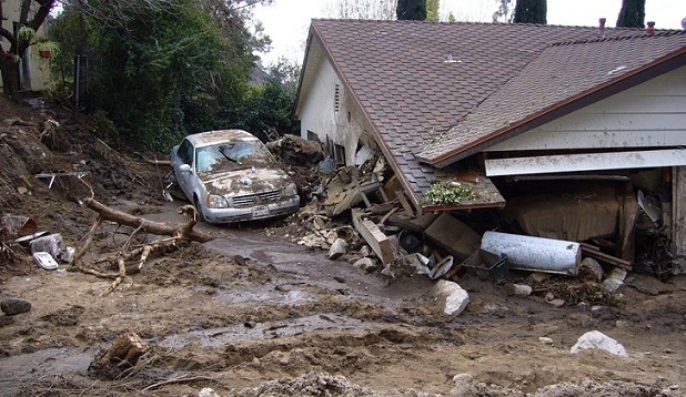
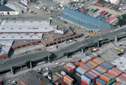
The Virginia Department of Mines, Minerals and Energy is leading an effort to map associated property damage from last year’s earthquake to inform community preparedness plans for future earthquakes in the region. Fortunately, the event last year was centered in a rural area and did not cause widespread severe damage or serious injuries, but that would not be the case in future events if they occur close to urban centers like Richmond or Charlottesville.
The earthquake was far enough (about 40 miles) from the densely populated Richmond, Virginia, area that there was no loss of life or serious property damage despite the presence of a large number of old, unreinforced masonry buildings. However, moderately heavy damage did occur to schools, businesses, and homes in rural Louisa County southwest of Mineral, Virginia. Widespread light-to-moderate damage occurred in the area from central Virginia to southern Maryland. In the nation’s capital, there was damage to several landmarks including the Washington Monument and Washington National Cathedral. The North Anna nuclear power station, located about 12 miles from the main shock epicenter, was shut down as a result of strong shaking from the earthquake.
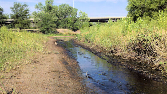
USGS scientists also recorded changes to groundwater levels within minutes to 24 hours after the earthquake, as far away as 350 miles from the epicenter. Changes in groundwater levels have been observed from other earthquakes around the world and are a reminder of the wide-ranging impacts of an earthquake.
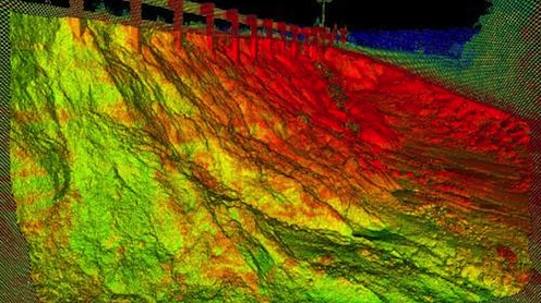
Mapping Underground Faults
Scientists are mapping faults and other geologic features to help refine their knowledge of the Central Virginia seismic zone. This will help determine the potential sizes of future earthquakes in the region and the likelihood of their occurring.
As part of this effort, USGS scientists conducted airborne geophysical surveys across parts of Louisa, Goochland and Fluvanna Counties from July 15 – 25, 2012. These data will be used to help develop 3D imagery of underground faults responsible for the earthquake. The instruments in the airplane took magnetic, gravity, and radiometric readings across the region. Subtle changes in the Earth’s magnetic and gravity fields can help scientists map contrasts in rock types and thus underground faults.
The Next East Coast Earthquake – Are You Ready?

In this Aug. 24, 2011 file photo, an angel, carved from Indiana limestone, lies shattered amid other damage on the roof of the Washington National Cathedral in Washington after an earthquake. An earthquake last August severely damaged its intricate stone work and architecture with repairs now estimated to cost $20 million. Even before the earthquake, though, a financial crisis forced the cathedral to slash its budget from $27 million to $13 million in recent years and cut its paid staff by more than half from 170 full-time employees to 70. (Associated Press Photo/J. Scott Applewhite)
Mark your calendar and participate in The Great SouthEast ShakeOut, one of the biggest earthquake drills in history. At 10:18 a.m. on October 18, 2012, participants will “drop, cover and hold on.” This will be a chance to practice what to do before an earthquake happens in your community, and to learn how to get better prepared for a quick recovery.
Georgia, South Carolina, North Carolina, Virginia, Maryland, and the District of Columbia are encouraging their schools, businesses, organizations, government agencies, communities, and households to participate.
Sign up and pledge to have your family, school, business, or organization participate in the drill.
Join Us for Commemorative Events in DC and Virginia
You are welcome to join the public lecture, “A History of Rubble and Rumblings: Earthquakes in the Eastern U.S.,” on September 5, 2012 at the USGS Headquarters in Reston, Virginia.
A press conference will be held on August 23, 2012 at 10:30 am outside the Washington Monument in Washington, DC, to commemorate the earthquake anniversary and discuss the upcoming SouthEast ShakeOut drill. Virginia, Maryland and DC officials are working with the USGS, Federal Emergency Management Agency, and the National Park Service on this event. USGS Director Marcia McNutt will be one of the event presenters. For more information, contact Brian Blake at bblake@cusec.org and 901-544-3570, or visit the Central U.S. Earthquake Consortium website.
More Information
Read a recent article by USGS scientists in the American Geophysical Union newspaper EOS titled, “The 2011 Virginia earthquake: What are scientists learning?”

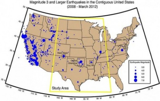
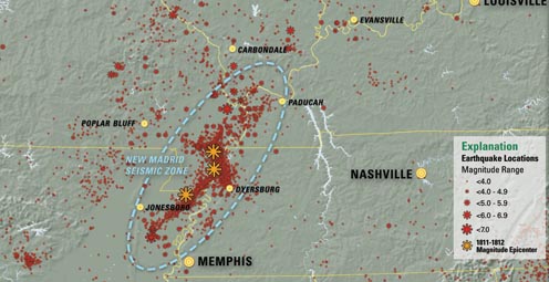
This map shows earthquakes greater than magnitude 3.0 since 1974 in the central and eastern United States.
Multimedia
Watch video interviews with four people discussing their experiences near the epicenter of last year’s earthquake.
Listen to two new podcast interviews with Associate Coordinator of the USGS Earthquake Hazards Program Mike Blanpied. The podcasts are:
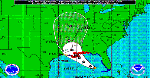
While Hurricane Isaac has passed, scientific work to understand the storm’s impact on Gulf Coast states continues. Read more
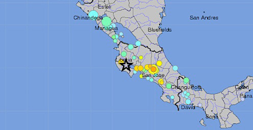
A magnitude 7.6 earthquake struck near the west coast of Costa Rica on September 5, 2012 at 14:42:10 UTC. Read more
Real-time map showing the extent of flooding (black dots) and drought (red dots) in the U.S. Read more
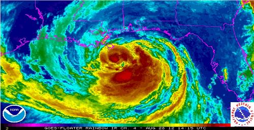
USGS scientists, engineers, and technicians are working along the Gulf coast in response to Hurricane Isaac. Read more
USGS scientists are providing up-to-date information. Read more
The U.S. Geological Survey is keeping careful watch as Tropical Storm Isaac continues to track northwest toward the west coast of Florida and the Gulf of Mexico. Read more
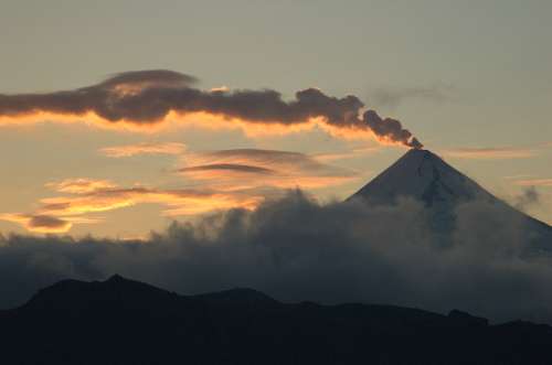
USGS scientists improve systems to monitor and forecast volcanic activity and track volcanic ash to help communities prepare. Read more
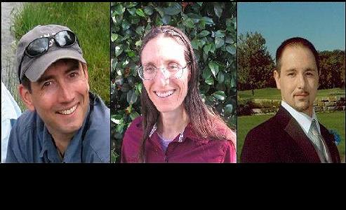
These 3 young scientists have forged ahead with innovative research at the frontiers of science. Learn more
The majority of the nation is facing dry conditions; in most areas drought conditions are expected to persist or intensify. Read more
The new “Did You See It?” website collects citizen observations of landslides. Read more
Please comment on the USGS’ draft science strategies! Read more
Citizen volunteers, portable instruments, and real-time maps help improve gathering of and access to earthquake data.Read more
The USGS and partners are designing an earthquake early warning system for California to help save lives and property.
Science or Soundbite? Is the recent increase in midcontinent earthquakes natural or man-made? Find out here.
Timing is everything! Consider helping track changes in spring’s arrival
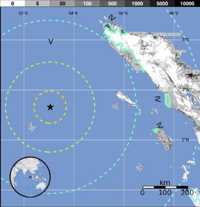
A magnitude-8.6 earthquake struck off the west coast of northern Sumatra Wednesday, April 11, 2012, at 8:38 a.m., UTC at the epicenter.
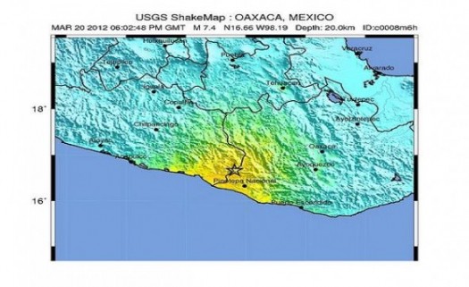
A magnitude-7.4 earthquake struck in the Mexican state of Oaxaca Tuesday, March 20, 2012, at 12:02 p.m., local time at the epicenter.
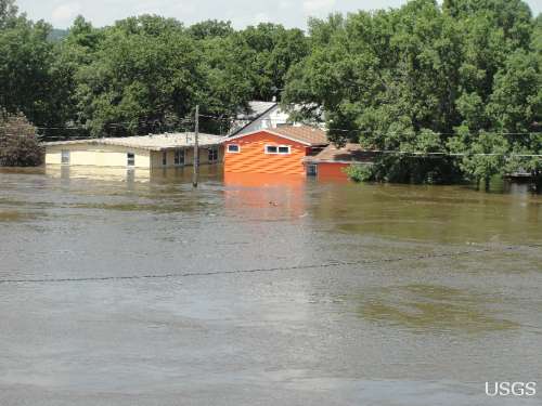
Flood Safety Awareness Week is March. 12-16. What can you do to prepare?
National Groundwater Awareness Week is Mar. 11-17, 2012. See how USGS science is connecting groundwater and surface water.
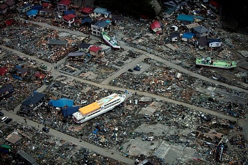
Since Japan’s March 11, 2011, Tohoku earthquake and subsequent tsunami, scientists at the USGS have learned much to help better prepare for a large earthquake in the United States.

Five USGS employees honored with Distinguished Service Awards for their service to the nation
The proposed USGS budget reflects research priorities to respond to nationally relevant issues, including water quantity and quality, ecosystem restoration, hydraulic fracturing, natural disasters such as floods and earthquakes, and support for the National Ocean Policy, and has a large R&D component.
Exploding lakes in Cameroon, Africa, have killed people and livestock. Find out how USGS science is helping prevent such an event from occurring again.
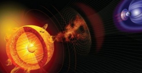
Everyone is familiar with weather systems on earth like rain, wind and snow. But space weather – variable conditions in the space surrounding Earth – has important consequences for our lives inside Earth’s atmosphere.
Scientists and communities are working together to make science more useful and communities safer. What one emergency manager has to say.
Modern volcano monitoring in the United States began with the founding of the Hawaiian Volcano Observatory in 1912. Living with volcanoes
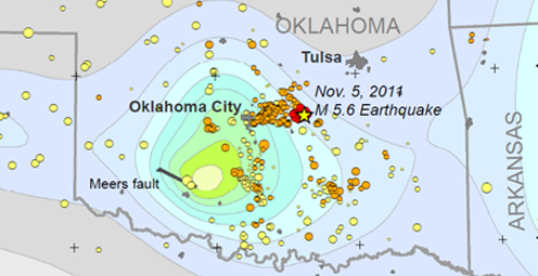
Shaking from Oklahoma's M5.6 main shock, the largest quake in the State's history, was felt from St. Louis to Lubbock. Number of quakes increasing in Oklahoma
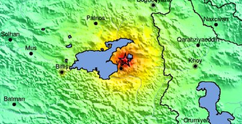
A magnitude-7.2 earthquake struck eastern Turkey on Sunday, October 23, 2011. History of strong earthquakes

It's only the beginning of their careers, but these 3 young scientists have forged ahead with innovative research at the frontiers of science. How they've transformed their fields
Oct. 9-15, 2011, is Earth Science Week, themed "Our-Ever Changing Earth," and Oct. 12, 2011, is International Day for Natural Disaster Reduction. Answers to questions posed by a changing world
Fire managers and the public can access online maps of current wildfire locations, thanks to a Web-based mapping application provided by the USGS and its partners.
On Feb. 7, 1812, at about 3 a.m., a third, and probably most widely felt of three major earthquakes, occurred in the central Mississippi River Valley. Similar risk today.
Rivers and streams are reaching record levels as a result of Hurricane Irene’s rainfall, with more than 80 USGS streamgages measuring record peaks.
Tuesday, August 23, 2011 at 01:51 PM a 5.8 Earthquake occurred 38 miles outside of Richmond, VA.
A new geologic map of Lassen Volcanic National Park and vicinity has been created. The map area includes the entire Lassen Volcanic Center, parts of three older volcanic centers, and the products of regional volcanism.
To better understand and reduce tsunami hazards, USGS scientists examined sediment deposited by the tsunami in and around Sendai, Japan, as part of an international tsunami survey team organized by Japanese scientific cooperators.
USGS crews continue to measure streamflow and collect water quality and sediment samples in the Ohio and Mississippi River basins using state-of-art instruments.
Many communities in South Dakota, North Dakota, Montana, Colorado, Wyoming and Iowa are dealing with record floodwaters and bracing for more flooding in the upcoming weeks.
Fire managers and the public can access online maps of current wildfire locations, thanks to a web-based mapping application provided by the USGS and its partners.
New Zealand has experienced another damaging earthquake close to the city of Christchurch, which is still recovering from the magnitude-6.1 earthquake that struck in February. This latest quake has resulted in additional damage to buildings and infrastructure.
The USGS-NASA Landsat 5 satellite captured this image of 39-mile track of destruction caused by a massive tornado on June 1 near Sturbridge, MA.
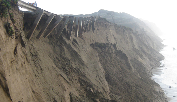
As hurricane season starts, researchers are modeling potential changes to coastal environments to identify communities vulnerable to extreme erosion during storms. Data collected before and after storm landfall are used to verify past forecasts and improve future predictions.
The effects of the March 11 magnitude 9.0 earthquake and resulting tsunami on Japan are being monitored using Landsat satellite data from the USGS.

The most recent earthquake in Japan affected water levels in groundwater wells all over the country. Water level fluctuations were recorded as far away as Illinois, Virginia, Missouri and Florida.

Volcanic activity continues in the Pu`u `O`o crater on Kilauea Volcano's east rift zone and in the Halema`uma`u Crater vent at Kilauea’s summit. Visit the USGS Hawaii Volcanoes Observatory site to get detailed Kilauea and Mauna Loa activity updates, recent volcano photos, recent earthquakes, and more.
Scientists unveil a catastrophic winter storm scenario that could possibly overwhelm California's flood protection system, and significantly disrupt Statewide social and economic systems.
Heavy rainfall could potentially destabilize hillsides. The USGS Landslide Hazards Web site has what you need to know if you live in an area prone to landslides.
The USGS and the National Weather Service have developed a new flood inundation map tool that enables management officials and residents to see where the potential threat of flooding is the highest along the Flint River near Albany, Georgia.

Volcanic eruptions have always been a part of human history; the American experience is no exception. On November 3rd, USGS’s Dr. John Eichelberger discusses new USGS programs which establish monitoring networks on all hazardous US volcanoes, to reduce the effects of volcanic hazards on communities.
Kilauea is Hawaii's youngest volcano and one of the world's most active. Get daily updates on ongoing eruptions from Kilauea's summit and east rift zone.
Looking for information on natural resources, natural hazards, geospatial data, and more? The USGS Education site provides great resources, including lessons, data, maps, and more, to support teaching, learning, K-12 education, and university-level inquiry and research.
The USGS PAGER system (Prompt Assessment of Global Earthquakes for Response) will now include estimated economic loss and casualty information. This system is used by emergency responders, government and aid officials, and the public to understand the scope of the disaster to develop the best response.
Flash flooding is one of the major causes of natural hazard-related deaths in the United States and is hard to predict, but data collected by the USGS is crucial to formulating better predictive models.
The USGS Science Strategy is a comprehensive report to critically examine the USGS's major science goals and priorities for the coming decade. The USGS is moving forward with these strategic science directions in response to the challenges that our Nation's future faces and for the stewards of our Federal lands.

In response to Hurricane Isaac, USGS has deployed several hundred storm surge sensors to collect information about the effects of Isaac on the Gulf Coast.

Join us on September 5th in Reston, VA for a free public lecture on the 2011 Virginia earthquake!

Join us on August 1 to learn more about the anatomy of flooding: What are the different causes of these extreme events, and how is USGS science helping prepare residents for future foods.

Join us on June 6 for a centennial look at the greatest volcanic eruption of the 20th century at our June Public Lecture!

In recognition of World Forestry Day, let’s take a glimpse at USGS science to understand the fate of forests from climate change.

The Volcano Hazards Program announces the establishment of the USGS California Volcano Observatory (CalVO), which expands and replaces the former Long Valley Observatory.

The U.S. Geological Survey had a very busy 2011 — below are a few of our highlights from last year.

On Nov. 3, USGS scientists Patrick Barnard and William Ellsworth will present a public lecture in Menlo Park, CA, providing Bay Area residents information about USGS research in the San Francisco Bay Area, including recent discoveries beneath San Francisco Bay and ongoing studies to better understand earthquake probabilities and the potential hazards associated with strong ground shaking.

Join USGS scientists on November 2nd to discuss the seismology of the M5.8 Virginia earthquake, its effects, and its context in the geology of Virginia.

![]() U.S. Department of the Interior |
U.S. Geological Survey
U.S. Department of the Interior |
U.S. Geological Survey
URL: www.usgs.gov/blogs/features/usgs_top_story/one-year-anniversary-magnitude-5-8-virginia-earthquake/?from=title
Page Contact Information: Ask USGS
Page Last Modified: September 14, 2011


