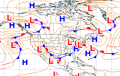
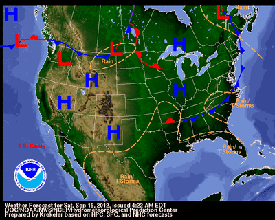
Fri, 14 Sep 2012 04:35:00 EDT A front extending from the lower Great Lakes to the lower Rio Grande Valley will move eastward off the New England/Mid-Atlantic coast by Saturday evening. The southern end of the front will dissipate on Saturday. Rain will develop along and ahead of the front from the Great Lakes to the Mid-Mississippi Valley moving off the coast by early Saturday. On the southern end of the front, showers and thunderstorms will develop over the Southern Plains/central Gulf Coast through late Friday night. Upper-level energy over the Southern Rockies/northern Mexico will aid in producing showers and thunderstorms over the Southern Plains on Saturday. Easterly flow off the Atlantic will produce scattered showers and thunderstorms along parts of the Southeast coast through Saturday. Latest local weather forecasts, warnings, watches, and advisories...
Tropical Storm Nadine Fri, 14 Sep 2012 05:00:54 EDT At 500 AM AST the center of Tropical Storm Nadine was located about 800 miles northeast of the northern Leeward Islands or about 765 miles east-southeast of Bermuda. Movement was toward the north-northwest near 15 MPH. A turn toward the north is expected later today followed by a turn toward the northeast and a decrease in forward speed Friday night and Saturday. Maximum sustained winds were near 70 MPH with higher gusts. Nadine is moving into an area where upper-level winds are not favorable for development and little change in strength is forecast during the next 48 hours. However, any strengthening would allow Nadine to become a hurricane. Details...
Eastern Pacific Tropical Storm Kristy Fri, 14 Sep 2012 05:00:15 EDT At 200 AM PDT the center of Tropical Storm Kristy was located about 105 miles northwest of Socorro Island or about 240 miles southwest of the southern tip of Baja California. Movement was toward the west-northwest near 10 MPH. This general motion is expected to continue today with a turn toward the northwest by tonight. Maximum sustained winds were near 60 MPH with higher gusts. Gradual but steady weakening is forecast during the next 48 hours and Kristy is forecast to become a remnant low by Sunday. Details...
Wed, 12 Sep 2012 10:55:33 EDT The United States Department of Agriculture Drought Portal provides resources and information related to the current drought crisis from across the Government. Throughout much of the country, communities are struggling with one of the worst droughts to strike the U.S. in decades. The lack of rain and high temperatures have done considerable damage to crops -- particularly those in the Midwest. USDA and other federal agencies are taking steps to help farmers, ranchers, and small businesses wrestling with this crisis. Details...
Earthquake Information from the U.S. Geological Survey
News from NOAA Disaster declaration issued for several U.S. fisheries Thu, 13 Sep 2012 12:30:32 -0400 Acting U.S. Secretary of Commerce Rebecca Blank today declared a commercial fishery failure for several locations in the United States. The disaster declarations makes it possible for Congress to appropriate money toward alleviating the financial hardship of fishermen affected by the fishery failures. If money is appropriated, NOAA will work closely with Congress and the governors representing the affected states to develop plans to assist coastal communities. Details...