Regional Planning Efforts
Coastal and marine spatial planning is a science-based tool that provides transparent information about ocean use, guarantees the public and stakeholders a voice early on in decisions affecting the ocean, and creates an inclusive, bottom-up, regional planning approach that gives the Federal Government, States, Tribes, and regions the ability to make more informed decisions about how best to use and protect the ocean, coasts, and Great Lakes. Simply stated, it is an information gathering and sharing process for analyzing current and anticipated uses of ocean, coastal, and Great Lakes areas.
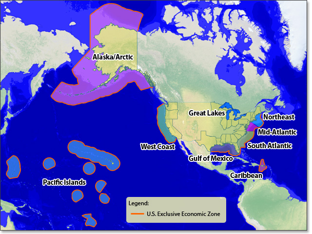
Under the National Ocean Policy’s Framework for Effective Coastal and Marine Spatial Planning, the United States is subdivided into nine regional planning areas. Each region would engage in a collaborative planning effort among Federal, State, and tribal partners who will develop regional goals, objectives, and ultimately regional CMS plans. An integral component of collaborative planning is good data and information on which to inform decisions. Regions compile information on their marine ecosystems, including structure, function, condition, cumulative impacts and services, current and emerging human uses, and projected effects of climate change. The resulting data and maps are made available to any interested party through regional data portals linked to a national information management system. Scientific assessments and decision support tools are then used to visualize and understand the implications of alternative choices for future ocean uses across the planning area. Guided by regional objectives, the resulting regional CMS Plan identifies and maps specific ocean areas most suitable to support different types of human uses while sustaining valued ecosystem functions and services.
Click on a region in the map or along the sidebar to view information on current regional planning efforts. If you would like a particular regional planning effort to be added, please let us know.