Map
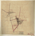
[Sketch of a portion of the Antietam battlefield, north of Sharpsburg, in the area of the West Wood, North Wood, and East Wood].
| Format |
Map |
|---|---|
| Dates |
1895 |
| Location |
Antietam Region Maryland United States |
| Language |
English |
| Subjects |
Antietam Region Antietam Region (Md.) Landowners Maryland United States |
- Title
- [Sketch of a portion of the Antietam battlefield, north of Sharpsburg, in the area of the West Wood, North Wood, and East Wood].
- Description
-
Shows names of some residents.
-
Title and date from Stephenson's Civil War maps, 1989.
-
Pen-and-ink and pencil over pen-and-ink grid on tracing linen, mounted on cloth.
-
LC Civil War maps (2nd ed.), H116
-
Available also through the Library of Congress web site as raster image.
-
1 ms. map : col., cloth ; 25 x 24 cm.
- Created Published
-
[1895]
- Subject Headings
-
-
Antietam Region (Md.)
-
-
Landowners--Maryland--Antietam Region
-
-
United States--Maryland--Antietam Region.
- Notes
-
-
Shows names of some residents.
-
-
Title and date from Stephenson's Civil War maps, 1989.
-
-
Pen-and-ink and pencil over pen-and-ink grid on tracing linen, mounted on cloth.
-
-
LC Civil War maps (2nd ed.), H116
-
-
Available also through the Library of Congress web site as raster image.
- Medium
-
1 ms. map : col., cloth ; 25 x 24 cm.
- Call Number
-
G3844.A6A1 1895 .S42
- Repository
-
Library of Congress Geography and Map Division Washington, D.C. 20540-4650 dcu
- Digital Id
-
g3844a cwh00116 http://hdl.loc.gov/loc.gmd/g3844a.cwh00116
- Library of Congress Catalog Number
- 2005625024
Rights & Access
The maps in the Map Collections materials were either published prior to 1922, produced by the United States government, or both (see catalogue records that accompany each map for information regarding date of publication and source). The Library of Congress is providing access to these materials for educational and research purposes and is not aware of any U.S. copyright protection (see Title 17 of the United States Code) or any other restrictions in the Map Collection materials.
Note that the written permission of the copyright owners and/or other rights holders (such as publicity and/or privacy rights) is required for distribution, reproduction, or other use of protected items beyond that allowed by fair use or other statutory exemptions. Responsibility for making an independent legal assessment of an item and securing any necessary permissions ultimately rests with persons desiring to use the item.
More about Copyright and other Restrictions
For guidance about compiling full citations consult Citing Primary Sources.
Part of...
-
Hotchkiss Map Collection
[345]
-
Civil War Maps
[2281]
-
Military Battles And Campaigns Cartographic Items
[3867]
-
Geography And Maps Division
[60803]
-
American Memory
[1120694]
More maps like this
-
 [Preliminary map of the Antietam battlefield area, including Sharpsburg and the adjacent territory].
Site:
American Memory-cultural, Main Catalog
Original Format:
Map
Date:
1895
View catalog record
[Preliminary map of the Antietam battlefield area, including Sharpsburg and the adjacent territory].
Site:
American Memory-cultural, Main Catalog
Original Format:
Map
Date:
1895
View catalog record
-
 [Preliminary field sketch of part of the Antietam battlefield, in the area north of Sharpsburg].
Site:
American Memory-cultural, Main Catalog
Original Format:
Map
Date:
1895
View catalog record
[Preliminary field sketch of part of the Antietam battlefield, in the area north of Sharpsburg].
Site:
American Memory-cultural, Main Catalog
Original Format:
Map
Date:
1895
View catalog record
-
 [Preliminary field sketch of part of the Antietam battlefield, north of Sharpsburg near the Toll Gate and Adam Michael's field].
Site:
American Memory-cultural, Main Catalog
Original Format:
Map
Date:
1895
View catalog record
[Preliminary field sketch of part of the Antietam battlefield, north of Sharpsburg near the Toll Gate and Adam Michael's field].
Site:
American Memory-cultural, Main Catalog
Original Format:
Map
Date:
1895
View catalog record
-
 [Preliminary field sketch of part of the Antietam battlefield, in the area north of Sharpsburg].
Site:
American Memory-cultural, Main Catalog
Original Format:
Map
Date:
1895
View catalog record
[Preliminary field sketch of part of the Antietam battlefield, in the area north of Sharpsburg].
Site:
American Memory-cultural, Main Catalog
Original Format:
Map
Date:
1895
View catalog record
-
 Field notes on Sharpsburg battle field /
Contributor:
Hotchkiss, Jedediah
Site:
American Memory-cultural, Main Catalog
Original Format:
Map
Date:
1894
View catalog record
Field notes on Sharpsburg battle field /
Contributor:
Hotchkiss, Jedediah
Site:
American Memory-cultural, Main Catalog
Original Format:
Map
Date:
1894
View catalog record
-
 [Northwest, or no. 1 sheet of preliminary map of Antietam (Sharpsburg) battlefield].
Contributor:
Hotchkiss, Jedediah
Site:
American Memory-cultural, Main Catalog
Original Format:
Map
Date:
1894
View catalog record
[Northwest, or no. 1 sheet of preliminary map of Antietam (Sharpsburg) battlefield].
Contributor:
Hotchkiss, Jedediah
Site:
American Memory-cultural, Main Catalog
Original Format:
Map
Date:
1894
View catalog record
-
 Northwest, or no. 1 sheet of preliminary map of Antietam (Sharpsburg) battlefield ; Southwest, or no. 2 sheet of preliminary map of Antietam (Sharpsburg) battlefield ...
Contributor:
Hotchkiss, Jedediah
Site:
American Memory-cultural, Main Catalog
Original Format:
Map
Date:
1894
View catalog record
Northwest, or no. 1 sheet of preliminary map of Antietam (Sharpsburg) battlefield ; Southwest, or no. 2 sheet of preliminary map of Antietam (Sharpsburg) battlefield ...
Contributor:
Hotchkiss, Jedediah
Site:
American Memory-cultural, Main Catalog
Original Format:
Map
Date:
1894
View catalog record
-
 [Sketch of a portion of the Antietam battlefield, north of Sharpsburg, in the area of the West Wood, North Wood, and East Wood].
Site:
American Memory-cultural, Main Catalog
Original Format:
Map
Date:
1895
View catalog record
[Sketch of a portion of the Antietam battlefield, north of Sharpsburg, in the area of the West Wood, North Wood, and East Wood].
Site:
American Memory-cultural, Main Catalog
Original Format:
Map
Date:
1895
View catalog record
-
 Antietam battlefield : preliminary map no. 3 /
Contributor:
Hotchkiss, Jedediah
Site:
American Memory-cultural, Main Catalog
Original Format:
Map
Date:
1895
View catalog record
Antietam battlefield : preliminary map no. 3 /
Contributor:
Hotchkiss, Jedediah
Site:
American Memory-cultural, Main Catalog
Original Format:
Map
Date:
1895
View catalog record
-
 The Antietam Campaign - Sept. 1862
Contributor:
Sneden, Robert Knox
Site:
American Memory-cultural
Original Format:
Map
Date:
1862
The Antietam Campaign - Sept. 1862
Contributor:
Sneden, Robert Knox
Site:
American Memory-cultural
Original Format:
Map
Date:
1862
-
 [Map of parts of Pennsylvania, Maryland, and Virginia covering areas from Harrisburg to Leesburg, and from Hancock to Baltimore].
Site:
American Memory-cultural, Main Catalog
Original Format:
Map
Date:
1863
View catalog record
[Map of parts of Pennsylvania, Maryland, and Virginia covering areas from Harrisburg to Leesburg, and from Hancock to Baltimore].
Site:
American Memory-cultural, Main Catalog
Original Format:
Map
Date:
1863
View catalog record
-
 S. S. Downin's plat of Joseph Poffenberger /
Contributor:
Downin, S. S.
Site:
American Memory-cultural, Main Catalog
Original Format:
Map
Date:
1851
View catalog record
S. S. Downin's plat of Joseph Poffenberger /
Contributor:
Downin, S. S.
Site:
American Memory-cultural, Main Catalog
Original Format:
Map
Date:
1851
View catalog record
-
 [Survey of the property of George Poffenberger and Mrs. Nicodemus in Washington County, Md.] /
Contributor:
Downin, S. S.
Site:
American Memory-cultural, Main Catalog
Original Format:
Map
Date:
1883
View catalog record
[Survey of the property of George Poffenberger and Mrs. Nicodemus in Washington County, Md.] /
Contributor:
Downin, S. S.
Site:
American Memory-cultural, Main Catalog
Original Format:
Map
Date:
1883
View catalog record
-
 Map of Carroll County, Md., showing rural delivery service /
Contributor:
United States. Post Office Dept
Site:
American Memory-cultural, Main Catalog
Original Format:
Map
Date:
1911
View catalog record
Map of Carroll County, Md., showing rural delivery service /
Contributor:
United States. Post Office Dept
Site:
American Memory-cultural, Main Catalog
Original Format:
Map
Date:
1911
View catalog record
-
 An illustrated atlas of Cecil County, Maryland /
Contributor:
Lake, Griffing & Stevenson
Site:
American Memory-cultural, Main Catalog
Original Format:
Map
Date:
1877
View catalog record
An illustrated atlas of Cecil County, Maryland /
Contributor:
Lake, Griffing & Stevenson
Site:
American Memory-cultural, Main Catalog
Original Format:
Map
Date:
1877
View catalog record
-
 Sketch book of Jed. Hotchkiss, Capt. & Top. Eng., Hd. Qrs., 2nd Corps, Army of N. Virginia : [Virginia].
Contributor:
Hotchkiss, Jedediah
Site:
American Memory-cultural, Main Catalog
Original Format:
Map
Date:
1862
View catalog record
Sketch book of Jed. Hotchkiss, Capt. & Top. Eng., Hd. Qrs., 2nd Corps, Army of N. Virginia : [Virginia].
Contributor:
Hotchkiss, Jedediah
Site:
American Memory-cultural, Main Catalog
Original Format:
Map
Date:
1862
View catalog record
You might also like
-
 Architectural Forum. Farm Security Administration housing
Site:
Prints & Photographs
Original Format:
Photo, Print, Drawing
Date:
1941
Architectural Forum. Farm Security Administration housing
Site:
Prints & Photographs
Original Format:
Photo, Print, Drawing
Date:
1941
-

 Maryland politics and the election of speaker. Speech of Hon. Jas. A. Stewart, in reply to Hon. Henry Winter Davis.
Contributor:
Stewart, James Augustus
Site:
Main Catalog
Original Format:
Book
Date:
1860
Maryland politics and the election of speaker. Speech of Hon. Jas. A. Stewart, in reply to Hon. Henry Winter Davis.
Contributor:
Stewart, James Augustus
Site:
Main Catalog
Original Format:
Book
Date:
1860
-
 Frank Pierce, one of the Eighth Massachusetts Regiment, diving for a missing rail on the road from Annapolis to Washington
Site:
Prints & Photographs, Main Catalog
Original Format:
Photo, Print, Drawing
Date:
1861
View catalog record
Frank Pierce, one of the Eighth Massachusetts Regiment, diving for a missing rail on the road from Annapolis to Washington
Site:
Prints & Photographs, Main Catalog
Original Format:
Photo, Print, Drawing
Date:
1861
View catalog record
-
 Shipped by the Grace of God, in good order and well conditioned, by [blank] in and upon the good Ship called the [blank] whereof is ...
Contributor:
Bills of lading [in blank]
Site:
American Memory-cultural
Original Format:
Book
Date:
1770
Shipped by the Grace of God, in good order and well conditioned, by [blank] in and upon the good Ship called the [blank] whereof is ...
Contributor:
Bills of lading [in blank]
Site:
American Memory-cultural
Original Format:
Book
Date:
1770
-
 Maryland sc. Know all men by these presents, that we [blank] of [blank] county, are held and firmly bound unto the state of Maryland, in ...
Contributor:
Maryland
Site:
American Memory-cultural
Original Format:
Book
Date:
1781
Maryland sc. Know all men by these presents, that we [blank] of [blank] county, are held and firmly bound unto the state of Maryland, in ...
Contributor:
Maryland
Site:
American Memory-cultural
Original Format:
Book
Date:
1781
-
 To his excellency the Governor, and the honorable council of the State of Maryland. The address of the subscribers, inhabitants of ... county, sheweth That ...
Contributor:
Maryland. Citizens
Site:
American Memory-cultural
Original Format:
Book
Date:
1785
To his excellency the Governor, and the honorable council of the State of Maryland. The address of the subscribers, inhabitants of ... county, sheweth That ...
Contributor:
Maryland. Citizens
Site:
American Memory-cultural
Original Format:
Book
Date:
1785