Map
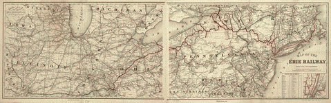
Map of the Erie Railway and its connections.
| Format |
Map |
|---|---|
| Contributors |
G.W. & C.B. Colton & Co |
| Dates |
1869 |
| Location |
Northeastern States United States |
| Language |
English |
| Subjects |
Erie Railway Northeastern States Railroads United States |
- Title
- Map of the Erie Railway and its connections.
- Description
-
Scale 1:1,267,200.
-
LC also has 1875 edition which lacks inset.
-
LC Railroad maps, 404
-
Description derived from published bibliography.
-
Map of the northeastern and north-central states showing drainage, cities and towns, township and county boundaries, and the railroads with emphasis on the main line. Incorporated in 1832 as the New York and Erie Rail Road. See entries 481-483. Became Erie Railway in 1861. In 1878 was known as the New York, Lake Erie, and Western Railroad. Incorporated again as the Erie in 1895.
-
Inset: [New York City and vicinity] 10 X 10 cm.
-
Available also through the Library of Congress Web site as a raster image.
-
col. map 47 x 139 cm.
- Creator
- G.W. & C.B. Colton & Co.
- Created Published
-
New York, 1869.
- Subject Headings
-
-
Erie Railway
-
-
Railroads--Northeastern States
-
-
United States--Northeastern States.
- Notes
-
-
Scale 1:1,267,200.
-
-
LC also has 1875 edition which lacks inset.
-
-
LC Railroad maps, 404
-
-
Description derived from published bibliography.
-
-
Map of the northeastern and north-central states showing drainage, cities and towns, township and county boundaries, and the railroads with emphasis on the main line. Incorporated in 1832 as the New York and Erie Rail Road. See entries 481-483. Became Erie Railway in 1861. In 1878 was known as the New York, Lake Erie, and Western Railroad. Incorporated again as the Erie in 1895.
-
-
Inset: [New York City and vicinity] 10 X 10 cm.
-
-
Available also through the Library of Congress Web site as a raster image.
- Medium
-
col. map 47 x 139 cm.
- Call Number
-
G3711.P3 1869 .G15
- Repository
-
Library of Congress Geography and Map Division Washington, D.C. 20540-4650 USA dcu
- Digital Id
-
g3711p rr004040 http://hdl.loc.gov/loc.gmd/g3711p.rr004040
- Library of Congress Catalog Number
- 98688655
Rights & Access
The maps in the Map Collections materials were either published prior to 1922, produced by the United States government, or both (see catalogue records that accompany each map for information regarding date of publication and source). The Library of Congress is providing access to these materials for educational and research purposes and is not aware of any U.S. copyright protection (see Title 17 of the United States Code) or any other restrictions in the Map Collection materials.
Note that the written permission of the copyright owners and/or other rights holders (such as publicity and/or privacy rights) is required for distribution, reproduction, or other use of protected items beyond that allowed by fair use or other statutory exemptions. Responsibility for making an independent legal assessment of an item and securing any necessary permissions ultimately rests with persons desiring to use the item.
More about Copyright and other Restrictions
For guidance about compiling full citations consult Citing Primary Sources.
Part of...
-
Railroad Maps, 1828 1900
[617]
-
Transportation And Communication Cartographic Items
[761]
-
Geography And Maps Division
[60803]
-
American Memory
[1121009]
More maps like this
-
 Railroad & express map of the middle states.
Contributor:
G.W. & C.B. Colton & Co
Site:
American Memory-cultural, Main Catalog
Original Format:
Map
Date:
1867
View catalog record
Railroad & express map of the middle states.
Contributor:
G.W. & C.B. Colton & Co
Site:
American Memory-cultural, Main Catalog
Original Format:
Map
Date:
1867
View catalog record
-
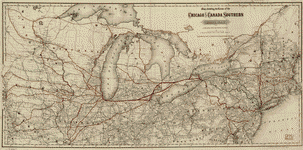 Map showing the route of the Chicago and Canada Southern Railway and its connecting lines.
Contributor:
G.W. & C.B. Colton & Co
Site:
American Memory-cultural, Main Catalog
Original Format:
Map
Date:
1872
View catalog record
Map showing the route of the Chicago and Canada Southern Railway and its connecting lines.
Contributor:
G.W. & C.B. Colton & Co
Site:
American Memory-cultural, Main Catalog
Original Format:
Map
Date:
1872
View catalog record
-
 A correct map of a section of the United States showing the allignment [sic] of the Pittsburgh, Marion, and Chicago Railway between Chewton, Penna. and ...
Contributor:
G.W. & C.B. Colton & Co
Site:
American Memory-cultural, Main Catalog
Original Format:
Map
Date:
1887
View catalog record
A correct map of a section of the United States showing the allignment [sic] of the Pittsburgh, Marion, and Chicago Railway between Chewton, Penna. and ...
Contributor:
G.W. & C.B. Colton & Co
Site:
American Memory-cultural, Main Catalog
Original Format:
Map
Date:
1887
View catalog record
-
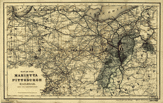 Map of the Marietta and Pittsburgh Railroad and its connections.
Contributor:
G.W. & C.B. Colton & Co
Site:
American Memory-cultural, Main Catalog
Original Format:
Map
Date:
1871
View catalog record
Map of the Marietta and Pittsburgh Railroad and its connections.
Contributor:
G.W. & C.B. Colton & Co
Site:
American Memory-cultural, Main Catalog
Original Format:
Map
Date:
1871
View catalog record
-
 New railway map of the United States.
Contributor:
G.W. & C.B. Colton & Co
Site:
American Memory-cultural, Main Catalog
Original Format:
Map
Date:
1867
View catalog record
New railway map of the United States.
Contributor:
G.W. & C.B. Colton & Co
Site:
American Memory-cultural, Main Catalog
Original Format:
Map
Date:
1867
View catalog record
-
 Colton's intermediate railroad map of the United States.
Contributor:
G.W. & C.B. Colton & Co
Site:
American Memory-cultural, Main Catalog
Original Format:
Map
Date:
1882
View catalog record
Colton's intermediate railroad map of the United States.
Contributor:
G.W. & C.B. Colton & Co
Site:
American Memory-cultural, Main Catalog
Original Format:
Map
Date:
1882
View catalog record
-
 Colton's railroad map (intermediate size) of the United States reduced from "Colton's railroad and commercial map of the United States."
Contributor:
G.W. & C.B. Colton & Co
Site:
American Memory-cultural, Main Catalog
Original Format:
Map
Date:
1870
View catalog record
Colton's railroad map (intermediate size) of the United States reduced from "Colton's railroad and commercial map of the United States."
Contributor:
G.W. & C.B. Colton & Co
Site:
American Memory-cultural, Main Catalog
Original Format:
Map
Date:
1870
View catalog record
-
 Colton's new railroad map of the United States & Canada.
Contributor:
G.W. & C.B. Colton & Co
Site:
American Memory-cultural, Main Catalog
Original Format:
Map
Date:
1876
View catalog record
Colton's new railroad map of the United States & Canada.
Contributor:
G.W. & C.B. Colton & Co
Site:
American Memory-cultural, Main Catalog
Original Format:
Map
Date:
1876
View catalog record
-
 Coltons railroad map of part of the United States north of the 37th parallel embracing the country between the Atlantic Ocean and the 96th Meridian ...
Contributor:
G.W. & C.B. Colton & Co
Site:
American Memory-cultural, Main Catalog
Original Format:
Map
Date:
1883
View catalog record
Coltons railroad map of part of the United States north of the 37th parallel embracing the country between the Atlantic Ocean and the 96th Meridian ...
Contributor:
G.W. & C.B. Colton & Co
Site:
American Memory-cultural, Main Catalog
Original Format:
Map
Date:
1883
View catalog record
-
 Map showing the California and Nevada Railroad and its extensions and connections.
Contributor:
G.W. & C.B. Colton & Co
Site:
American Memory-cultural, Main Catalog
Original Format:
Map
Date:
1882
View catalog record
Map showing the California and Nevada Railroad and its extensions and connections.
Contributor:
G.W. & C.B. Colton & Co
Site:
American Memory-cultural, Main Catalog
Original Format:
Map
Date:
1882
View catalog record
-
 Map showing the route of the Continental Railway and its connecting lines.
Contributor:
G.W. & C.B. Colton & Co
Site:
American Memory-cultural, Main Catalog
Original Format:
Map
Date:
1873
View catalog record
Map showing the route of the Continental Railway and its connecting lines.
Contributor:
G.W. & C.B. Colton & Co
Site:
American Memory-cultural, Main Catalog
Original Format:
Map
Date:
1873
View catalog record
-
 Maps showing the Florida Transit and Peninsula Rail Road and its connections.
Contributor:
G.W. & C.B. Colton & Co
Site:
American Memory-cultural, Main Catalog
Original Format:
Map
Date:
1882
View catalog record
Maps showing the Florida Transit and Peninsula Rail Road and its connections.
Contributor:
G.W. & C.B. Colton & Co
Site:
American Memory-cultural, Main Catalog
Original Format:
Map
Date:
1882
View catalog record
-
 Map showing the line of the Plymouth, Kankakee, & Pacific Railroad and its connections.
Contributor:
G.W. & C.B. Colton & Co
Site:
American Memory-cultural, Main Catalog
Original Format:
Map
Date:
1871
View catalog record
Map showing the line of the Plymouth, Kankakee, & Pacific Railroad and its connections.
Contributor:
G.W. & C.B. Colton & Co
Site:
American Memory-cultural, Main Catalog
Original Format:
Map
Date:
1871
View catalog record
-
 Map showing the route and connections of the Wheeling and Cincinnati Mineral Railway.
Contributor:
G.W. & C.B. Colton & Co
Site:
American Memory-cultural, Main Catalog
Original Format:
Map
Date:
1882
View catalog record
Map showing the route and connections of the Wheeling and Cincinnati Mineral Railway.
Contributor:
G.W. & C.B. Colton & Co
Site:
American Memory-cultural, Main Catalog
Original Format:
Map
Date:
1882
View catalog record
-
 Railroad map of the state of New York to accompany the twelfth annual report of the Board of Railroad Commissioners of the State of New ...
Contributor:
G.W. & C.B. Colton & Co
Site:
American Memory-cultural, Main Catalog
Original Format:
Map
Date:
1894
View catalog record
Railroad map of the state of New York to accompany the twelfth annual report of the Board of Railroad Commissioners of the State of New ...
Contributor:
G.W. & C.B. Colton & Co
Site:
American Memory-cultural, Main Catalog
Original Format:
Map
Date:
1894
View catalog record
-
 Map showing the line of the Cairo & Fulton Railroad and its connections.
Contributor:
G.W. & C.B. Colton & Co
Site:
American Memory-cultural, Main Catalog
Original Format:
Map
Date:
1871
View catalog record
Map showing the line of the Cairo & Fulton Railroad and its connections.
Contributor:
G.W. & C.B. Colton & Co
Site:
American Memory-cultural, Main Catalog
Original Format:
Map
Date:
1871
View catalog record
You might also like
-
 H.R.15498 - Rural Rail Preservation and Improvement Act
Contributor:
Thone, Charles
Site:
Thomas-legislative
Original Format:
Legislation
Date:
1974-06-19
H.R.15498 - Rural Rail Preservation and Improvement Act
Contributor:
Thone, Charles
Site:
Thomas-legislative
Original Format:
Legislation
Date:
1974-06-19
-
S.1216 - North Eastern Rail Service Preservation Act
Contributor:
Saxbe, William B.
Site:
Thomas-legislative
Original Format:
Legislation
Date:
1973-03-14
-
S.2060 - Emergency Rail Services Act Amendments
Contributor:
Hartke, Vance
Site:
Thomas-legislative
Original Format:
Legislation
Date:
1973-06-25
-
S.3438 - Rural Rail Preservation and Improvement Act
Contributor:
Mondale, Walter F.
Site:
Thomas-legislative
Original Format:
Legislation
Date:
1974-05-02
-
S.3569 - Amtrak Improvement Act
Contributor:
Hartke, Vance
Site:
Thomas-legislative
Original Format:
Legislation
Date:
1974-06-03
-
H.R.15194 - A bill to require the Secretary of Transportation to investigate and report to the Congress with respect to whether certain railroad facilities and ...
Contributor:
Carey, Hugh L.
Site:
Thomas-legislative
Original Format:
Legislation
Date:
1974-06-05