US. Pasture and Range Conditions. Click to enlarge image.
With the summer crop season winding down at a rapid pace, the agricultural weather focus is turning to winter wheat. In the hard red winter wheat belt of the Great Plains, wheat planting got off to a slow start due to extremely dry conditions. By September 9 , planting was behind the five-year average pace in all seven major production states on the Plains, according to USDA’s National Agricultural Statistics Service. Planting progress was more than five percentage points behind the average in Colorado (0% planted versus the average of 13%), Nebraska (8 vs. 16%), and South Dakota (8 vs. 14%). Ongoing drought across the nation’s mid-section is also reflected by current rangeland and pasture conditions. On September 9, nearly all (97%) of the rangeland and pastures were rated very poor to poor in Nebraska, along with 92% in Missouri, 89% in Kansas, 87% in Colorado, and 86% in New Mexico. Farther east, however, pastures have improved with recent rainfall. Most notably, pastures in Illinois were rated 59% very poor to poor on September 9, a significant improvement from 72% a week ago and 90% on August 26. Read more »
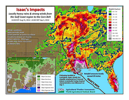
Isaac's impacts: Locally heavy rains and strong winds from the Gulf Coast region to the corn belt.
Visit www.usda.gov/drought for the latest information regarding USDA’s Drought Disaster response and assistance.
Hurricane Isaac moved ashore early Wednesday, August 29, in southeastern Louisiana with maximum sustained winds near 80 mph. Once inland, the storm steadily weakened, losing its tropical characteristics over Missouri on Saturday, September 1. Nevertheless, Isaac’s remnant circulation continued to drift across the eastern Corn Belt during the Labor Day weekend, generating locally heavy showers from the lower Midwest into the mid-Atlantic region. Storm-total rainfall reached 10 to 20 inches in the central Gulf Coast region, while some drought-affected areas in Arkansas, Missouri, and Illinois received in excess of 4 inches. In the Mid-South and lower Midwest, positive effects of Isaac’s rainfall included replenishment of soil moisture in preparation for the soft red winter wheat planting season and starting the process of pasture recovery. Read more »
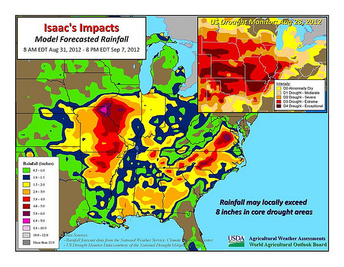
Isaac's Impacts: Model Forecasted Rainfall, August 31, 2012. Click to enlarge image.
Visit www.usda.gov/drought for the latest information regarding USDA’s Drought Disaster response and assistance.
Hurricane Isaac has grabbed most of the weather headlines in recent days, but drought remains deeply entrenched across nearly two-thirds of the continental United States. According to the latest U.S. Drought Monitor, dated August 28, drought covered 62.9% of the Lower 48 states, down only slightly from a peak of 63.9% on July 24. However, during the five-week period from July 24 to August 28, the portion of the country in exceptional drought (D4) increased from 2.4 to 6.0%. Read more »
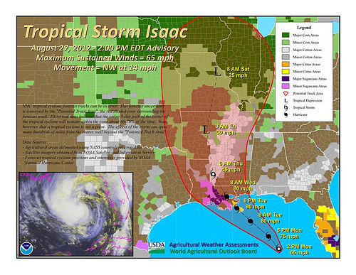
Tropical Storm Isaac - August 27, 2012 as of 2pm EDT. Click to enlarge image.
Visit www.usda.gov/drought for the latest information regarding USDA’s Drought Disaster response and assistance.
In recent days, some of the weather focus has shifted from drought to the tropics. Indeed, Tropical Storm Isaac is bearing down on the central Gulf Coast of the United States, and hurricane warnings have been issued from Morgan City, Louisiana, to Destin, Florida. According to the National Hurricane Center, a coastal storm surge of 6 to 12 feet can be expected in southeastern Louisiana and southern portions of Alabama and Mississippi, along and just east of Isaac’s expected path. On its present course, Isaac should reach the central Gulf Coast late Tuesday. The NHC indicates that further strengthening can be expected prior to landfall, and Isaac should reach the coast as a Category 1 hurricane – with sustained winds of 74 to 95 mph. Another threat related to Isaac will be flooding rains. Rainfall has already topped 10 inches in parts of southeastern Florida, where locally heavy squalls persist. In the central Gulf Coast region, widespread 6- to 12-inch totals are forecast, with isolated amounts near 18 inches possible. Crops potentially in the path of Isaac include cotton and sugarcane. By August 26, cotton bolls open in the Delta States ranged from 32% in Missouri to 61% in Louisiana. Cotton in the open-boll stage of development is especially vulnerable to damage when high winds and heavy rain occur. In Louisiana, more than one-quarter (28%) of the new sugarcane crop had been planted by August 19. Many other crops, including unharvested corn, rice, and soybeans, could be susceptible to lodging (i.e. being flattened or blown over) or quality degradation due to Isaac’s effects. Read more »
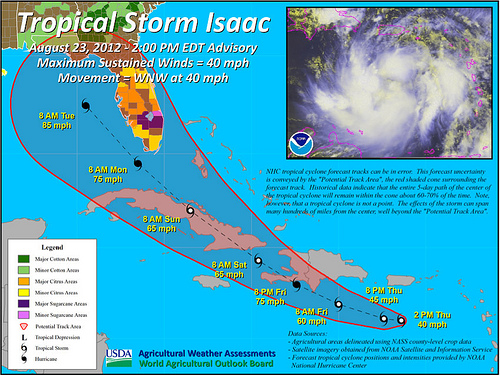
Tropical Storm Isaac as of August 23 at 2pm EDT. Click image to enlarge.
Visit www.usda.gov/drought for the latest information regarding USDA’s Drought Disaster response and assistance.
The latest U.S. Drought Monitor, dated August 21, reflects a persistence of drought across the majority of the nation. Overall conterminous U.S. drought coverage stands at 63%, up slightly from 62% on August 14 but below the July 24 maximum of 64%. In the last week, U.S. corn in drought climbed a percentage point to 86%, but still below the July 24 peak of 89%. Soybeans in drought remained steady at 83%, five percentage points below the July 24 high. Hay in drought remained steady at 63% for the third consecutive week, down from a high of 66% on July 17 and 24. Cattle in drought rose a percentage point in the last week to 72%, slightly below the July 17 and 24 peak of 73%. Crops and cattle in exceptional drought (D4) remained nearly unchanged – 8% of the U.S. corn, 10% of the soybeans, 12% of the hay, and 14% of the cattle. Read more »
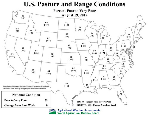
U.S. Pasture and Range Conditions, August 19, 2012. Click to enlarge image.
Visit www.usda.gov/drought for the latest information regarding USDA’s Drought Disaster response and assistance.
During the last week, the heat that has been affecting much of the nation’s heartland all summer has shifted into the western United States. As a result, wildfires have flourished in parts of the West, particularly in Idaho and northern California. By August 20, the area burned by year-to-date U.S. wildfires reached 6.9 million acres, well above the 10-year average of 5.3 million acres. Read more »