
Earthquake Hazards Program

The USGS Earthquake Hazards Program is part of the National Earthquake Hazards Reduction Program (NEHRP), established by Congress in 1977. We monitor and report earthquakes, assess earthquake impacts and hazards, and research the causes and effects of earthquake.
Latest Earthquakes
Real-time Earthquake MapInteractive map and list of latest earthquakes
-
Get Real-time Data Sent to You
Get real-time earthquake notifications sent to you using a number of popular mediums: Feeds, Email, Twitter, etc… -
Did You Feel It?
Feel an earthquake? Report it here.
Regional Activities
Our scientists study earthquakes around the world. Learn about research conducted in our regional offices, regional seismic network monitoring, and local activities of interest.
Significant Earthquakes Past 30 Days
- M 6.4, 29km SSW of Tanaga Volcano, Alaska Wednesday, September 26, 2012 23:39:54 UTC
- M 6.2, 75km NNE of La Paz, Mexico Tuesday, September 25, 2012 23:45:26 UTC
- M 3.4, 0km WSW of Beverly Hills, California Friday, September 07, 2012 07:03:09 UTC
- M 5.5, 2km SSW of Jiaokui, China Friday, September 07, 2012 03:19:42 UTC
- M 7.6, 12km ENE of Hojancha, Costa Rica Wednesday, September 05, 2012 14:42:07 UTC
- M 6.2, 244km S of Sidorukun, Indonesia Monday, September 03, 2012 18:23:04 UTC
- M 7.6, 88km E of Sulangan, Philippines Friday, August 31, 2012 12:47:33 UTC
- M 6.8, 88km NW of Olonkinbyen, Svalbard and Jan Mayen Thursday, August 30, 2012 13:43:25 UTC
- M 4.1, 3km NE of Yorba Linda, California Wednesday, August 29, 2012 20:31:00 UTC
Featured Items
-
Dynamic Stress Triggering in 2004 Sumatra Earthquake
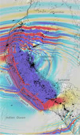
Over a 300-km-long largely transform section of the backarc, M≥4.5 earthquakes stopped for five years, and over a 750-km-long backarc section, the rate of transform events dropped by two-thirds, while the rate of rift events increased eightfold.
View Research -
The Great ShakeOut
You are invited to join thousands of people who will Drop, Cover, and Hold On! in the 2012 Great ShakeOut happening all over the US and in several other countries around the world.
View Site -
Slab1.0 Interactive Map
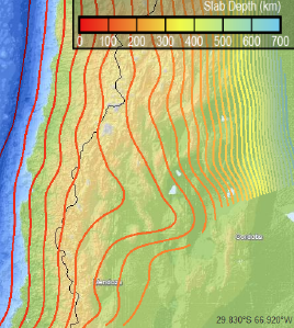
The Slab1.0 three-dimensional subduction zone geometry model is now available via an interactive map and query. Search for modeled slab depth, strike and dip at a given location in the majority of global subduction zones.
View Application -
Earthquake Early Warning
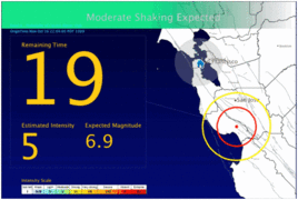
An Earthquake Early Warning System for the west coast of the United States is being developed by the United States Geological Survey in cooperation with scientists at academic institutions including: California Institute of Technology, University of California at Berkeley, and University of Washington.
View Research -
Hazard Curve Application
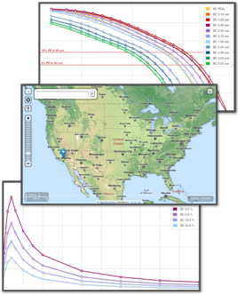
Interested in probabilistic hazard curve data for the conterminous US? Try out the new hazard web application that lets you view hazard curves and dynamically generate uniform hazard response spectra (UHRS). The application also provides instructions for programmatic access to the 2008 National Seismic Hazard Mapping Program data.
View Application
