-
Fire Danger is HIGH in the Parks - Observe Current Fire Restrictions
On Saturday, July 14, 2012, fire restrictions began and will continue until further notice. Follow link to read the full news release for info on wood, BBQ, & propane fires, and smoking in campgrounds, picnic, & wilderness areas below 6,000 ft. More »
-
Road Construction Delays in Sequoia NP thru end of November 2012 (if entering/exiting Hwy 198)
Expect 20-minute to 1-hour delays on weekdays and 20-minute delays on weekends along main road through parks. Weeknight closures with one pass through the construction zone at 11:30 p.m. See link to schedule and map or call 559-565-3341 (press 1, 1, 1,). More »
-
22-foot Vehicle Length Limit in Sequoia NP thru end of November 2012 (if entering/exiting Hwy 198)
Planning to see the "Big Trees" in Sequoia National Park? If you enter/exit via Hwy. 198, all vehicles must be less than 22 feet in length. Even vehicles towing trailers must be less than 22 feet in combined length. Longer vehicles must enter at Hwy. 180. More »
Things to Know Before You Come
|
Please read important park alerts by clicking the red tab above before you come to the parks. Improve Your Visit - Take a moment to click on the topics below: Important Alerts Check our alerts at the top of every page for warnings about road construction delays, closures, vehicle length-limits, on-going chain control restrictions during and after snow storms, or other important messages you need to know before you leave home. Visitor Guide (Park Newspaper) Start by reading our Visitor Guide. Published five times a year, you'll find most of your questions will be answered here. Park News Check our News Releases page for the most recent happenings in the parks. Weather Forecasts Check our Current Conditions page for the area forecasts where you'll be visiting just before leaving home. Be prepared with the proper clothing, hiking, or camping gear for the area (elevation) and season of your visit. Shuttle Service Park shuttles run from May 24 to September 9, 2012. Download the schedule here. Special 2012-13 In-park Holiday Shuttles run November 22-25 and December 26 - January 1. More...
Regular tour season runs from May 12 - November 25, 2012, weather permitting. Visit Crystal Cave Information page for tour schedules, tickets, special Halloween tours, and much more. See also Crystal Cave news release (PDF, JPEG pg. 1, JPEG pg. 2). Five Major Areas Learn about the five developed areas of the parks' front-country, and the highlights of each area. Bears and Proper Food Storage Stay safe and help keep bears wild - store your food properly. Learn how here. Accessibility Learn where accessible facilities and features are located in the parks. Pets Read the rules for pets in the parks and in the surrounding national forests - they're different in each. Ranger-led Activities (free) Before you leave home visit our Ranger-led Programs page for posted program flyers up to two weeks in advance. Safety Your safety is your responsibility. Learn about the unfamiliar hazards you may encounter in natural areas. Gasoline and Automobile Services There are no gas stations inside the park boundaries. Last gas before the south entrance (to Sequoia) on Highway 198 is in Three Rivers. Last gas before the north entrance (to Kings Canyon) on Highway 180 is in Clingan's Junction/Dunlap 20 miles west of Grant Grove. Emergency gas can be purchased at Wuksachi Lodge in Sequoia National Park and the Grant Grove Market in Kings Canyon National Park. < p>
Emergency Car Repairs: Cell Phones & GPS Cell phones and GPS generally don't work in the parks. Designate a contact person at home to communicate through. It's best to use printed maps of the parks for the most reliable driving directions. Campfires Fire restrictions begin when fire danger increases - including limits on campfires, barbeques and smoking. National Parks vs National Forests? Some rules vary between National Parks and National Forests. Since you go in and out of these agency lands when visiting this area, it's important to know which is which. Weapons |

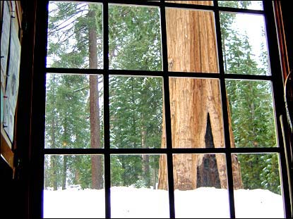
Winter view from inside the Giant Forest Museum looking out at the Sentinel, a giant sequoia tree. Photo by SMB.
Gigantic landscapes, long distances Extreme elevation range, steep curvy roads, variable weather Remote country Bears and wildlife Land shaped by fire Why use fire? It is a natural part of these landscapes. Plants and animals here have adapted to it. Some actually need periodic fire for survival. Sequoias, for example, have adaptations to survive fire, and have trouble reproducing without it. Flames clear and fertilize the ground under the big trees, leaving the kind of soil in which their seeds germinate best. Not coincidentally, fire also opens sequoia cones, so that seeds rain down on this excellent seedbed. In addition, fires remove ground vegetation and forest litter that compete with the seedlings for moisture, nutrients, and sunlight. Throughout the parks, complete fire suppression would harm the parks' natural character and increase the threat of catastrophic wildfires. Therefore, the park uses natural fires as well as prescribed burns to maintain these ecosystems. more... 
Call or visit the nearest park visitor center to find out today's projected air quality index.
NPS
Air quality 
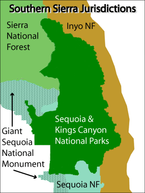
NPS Graphic Park, Forest, or Monument? All are federal land. Each exists for the benefit of society. But each has a different history, purpose, and set of rules governing its use. Together, they provide for a wide spectrum of uses. Recognize the different kinds of land in these mountains and the rules that govern each. Driving you will see signs for national parks, national forests, and national monuments. What is the difference? All are federal land. All exist for the benefit of society. But each has a different history, purpose, and set of rules. Together they provide for a wide spectrum of uses. National parks strive to keep landscapes unimpaired for future generations. They protect natural and historic features while offering light-on-the-land recreation. Park rangers work for the National Park Service—part of the U.S. Department of the Interior. National forests, managed under a "multiple-use" concept, provide services and commodities that may include lumber, cattle grazing, minerals, and recreation with and without vehicles. Forest rangers work for the U.S. Forest Service, an agency in the Department of Agriculture. Both agencies manage wilderness and other areas where they strive for maximum protection of natural resources. For example, part of Sequoia National Forest has been designated Giant Sequoia National Monument to emphasize protection of sequoias. Parks, forests, and monuments may have different rules in order to achieve their goals. more... |
Did You Know?

The Sierra Nevada is still growing today. The mountains gain height during earthquakes on the east side of the range. But the mountains are being shortened by erosion almost as quickly as they grow. This erosion has deposited sediments thousands of feet thick on the floor of the San Joaquin Valley.
