AIS Data
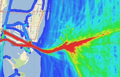
Automatic Identification System (AIS) data are information collected by the U.S. Coast Guard to track real-time vessel information such as ship identity, purpose, course, and speed, primarily in coastal U.S. waters. However, the data set featured on this website is the 2009 archived AIS data set intended to be used by the ocean planning community to better understand vessel traffic patterns. For more information, visit the Nationwide Automatic Identification System website.
The AIS Data Handler
The AIS Data Handler streamlines the acquisition, loading, filtering, display, and analysis of AIS data with its collection of data conversion tools and an ArcGIS add-in. The data and AIS Data Handler are accompanied by supporting resources, including metadata, and a tutorial for processing AIS records.
The AIS Data Handler and accompanying databases were developed as part of the Multipurpose Marine Cadastre project by the NOAA Coastal Services Center and the Department of the Interior’s Bureau of Ocean Energy Management. Original source data were acquired from the U.S. Coast Guard's National AIS Program. The data handler is designed to support the ocean planning community by generating synthesized products to better understand patterns of marine transportation and potential use conflicts between vessels and other activities.
AIS Data Handler Database: This archive of AIS data originates from U.S. Coast Guard land-based receiver stations. The database contains records for U.S. coastal waters for calendar year 2009. Records are filtered to 1 minute and formatted in zipped, monthly file geodatabases by Universal Transverse Mercator (UTM) zone. View the index map of UTM zones for an area of interest. To download AIS data please request a user name and password.
AIS Data Handler Pre-Processor: For users with their own AIS receivers or other sources of raw data, this pre-processor contains both a command-line tool to help filter raw AIS log files and an add-in tool to load the data into a file geodatabase.
AIS Data Handler Add-In: This add-in tool extends ArcGIS with new functions to clean, filter, build, and analyze AIS data. Use this tool to process the data from the AIS Data Handler Database or from the output of the AIS Data Handler Pre-Processor.
System Requirements:
Operating System: Windows XP, Vista, or 7 (32 or 64-bit)
ArcGIS 10.x – full ArcInfo license required for relationship class functionality
Spatial Analyst – for density grid functionality
Other Resources
Lane, B. AIVDM/AIVDO AIS Message Parser. Accessed November 2010 at www.aisparser.com.
Calder, B., and K. Schwehr. 2009. “Traffic Analysis for the Calibration of Risk Assessment Methods.” Technical paper. U.S. Hydro 2009 Conference, May 11-14, Norfolk, VA. Accessed at www.thsoa.org/us09papers.htm.
Ristic, B., B. La Scala, M. Morelande, and N. Gordon. 2008. “Statistical Analysis of Motion Patterns in AIS Data: Anomaly Detection and Motion Prediction.” In Proc. 11th International Conference on Information Fusion, Cologne, Germany, June 2008. Accessed at http://isif.org/fusion/proceedings/fusion08CD/papers/1569102521.pdf.
Silber, G.K., and S. Bettridge. 2010. “Vessel Operations in Right Whale Protection Areas in 2009.” U.S. Department of Commerce, NOAA Tech. Memo. NMFS-OPR-44. Accessed at www.nmfs.noaa.gov/pr/pdfs/shipstrike/opr44.pdf.
U.S. Coast Guard (USCG) Navigation Center. “Automated Information System (AIS): AIS Messages.” Website. Accessed October 15, 2010, at www.navcen.uscg.gov/?pageName=AISMessages.
Hatch L.T., C. Clark, R. Merrick, S. Van Parijs, D. Ponirakis, K. Schwehr, M. Thompson, and D. Wiley. 2008. “Characterizing the Relative Contributions of Large Vessels to Total Ocean Noise Fields: A Case Study Using the Gerry E. Studds Stellwagen Bank National Marine Sanctuary.” Environmental Management. Volume 42, Number 5. DOI 10.1007/s00267-008-9169-4. Accessed at www.springerlink.com/content/u1p51226016240lp/.
Acknowledgments
U.S. Coast Guard Navigation Center
U.S. Coast Guard National Automatic Identification System (NAIS) Program
NOAA Office of Coast Survey
Stellwagen Bank National Marine Sanctuary