- Habitat Home
- About Us
- Our Work
- About Habitat
- Funding Opportunities
- Our Partners
- News & Multimedia
- Publications & Resources

|
 |
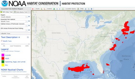
Essential Fish Habitat Mapper v3.0
The EFH Mapper is a one-stop tool for viewing the spatial representations of fish species, their life-stages and important habitats. We provide links to supporting materials, including fishery management plans, and the ability to download GIS data.
This one-of-a-kind tool displays maps for essential fish habitat (EFH), habitat areas of particular concern, and EFH areas protected from fishing. You have the ability to discover the species that spawn, grow, or live in a chosen location on the map and generate a report with supporting documentation. For species with distinct life-stages, the map offers locations for each individual stage.
New in version 3.0: NOAA Nautical Charts
Our EFH Mapper just got a fresh new look! We added NOAA nautical charts, which are updated monthly and immediately available through the EFH Mapper. You can use the transparency sliders to view underlying ocean and nautical chart base maps. The new ocean base map includes surface and subsurface feature names and derived depths.
We also expanded the toolbar to provide a more user-friendly experience.