Map
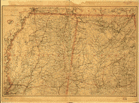
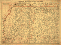
[Base map of Alabama].

| Format |
Map |
|---|---|
| Dates |
1893 |
| Location |
Alabama United States |
| Language |
English |
| Subjects |
Alabama United States |
- Title
- [Base map of Alabama].
- Description
-
Shows names of counties, major cities and towns, and rivers.
-
Title, date, and scale from Stephenson's Civil War maps, 1989.
-
Pen-and-ink on tracing linen, mounted on cloth.
-
Stamped in green ink in top left corner: Excelsior linen cloth.
-
LC Civil War maps (2nd ed.), H201
-
Available also through the Library of Congress web site as raster image.
-
On verso partially obscured by mounting: Unpublished tracings of states and counties, prepared for the purpose of illustrating proposed report of Jed. Hotchkiss on the geology of all states and countries represented in the mines and mining exhibits at the Columbian Exposition, 1893.
-
In pencil on verso: 214.
-
1 ms. map : cloth ; 35 x 27 cm., on sheet 51 x 60 cm.
- Created Published
-
[1893]
- Subject Headings
-
-
Alabama
-
-
United States--Alabama.
- Notes
-
-
Shows names of counties, major cities and towns, and rivers.
-
-
Title, date, and scale from Stephenson's Civil War maps, 1989.
-
-
Pen-and-ink on tracing linen, mounted on cloth.
-
-
Stamped in green ink in top left corner: Excelsior linen cloth.
-
-
LC Civil War maps (2nd ed.), H201
-
-
Available also through the Library of Congress web site as raster image.
-
-
On verso partially obscured by mounting: Unpublished tracings of states and counties, prepared for the purpose of illustrating proposed report of Jed. Hotchkiss on the geology of all states and countries represented in the mines and mining exhibits at the Columbian Exposition, 1893.
-
-
In pencil on verso: 214.
- Medium
-
1 ms. map : cloth ; 35 x 27 cm., on sheet 51 x 60 cm.
- Call Number
-
G3970 1893 .B3
- Repository
-
Library of Congress Geography and Map Division Washington, D.C. 20540-4650 dcu
- Digital Id
-
g3970 cwh00201 http://hdl.loc.gov/loc.gmd/g3970.cwh00201
- Library of Congress Catalog Number
- 2005625108
Rights & Access
The maps in the Map Collections materials were either published prior to 1922, produced by the United States government, or both (see catalogue records that accompany each map for information regarding date of publication and source). The Library of Congress is providing access to these materials for educational and research purposes and is not aware of any U.S. copyright protection (see Title 17 of the United States Code) or any other restrictions in the Map Collection materials.
Note that the written permission of the copyright owners and/or other rights holders (such as publicity and/or privacy rights) is required for distribution, reproduction, or other use of protected items beyond that allowed by fair use or other statutory exemptions. Responsibility for making an independent legal assessment of an item and securing any necessary permissions ultimately rests with persons desiring to use the item.
More about Copyright and other Restrictions
For guidance about compiling full citations consult Citing Primary Sources.
Part of...
-
Hotchkiss Map Collection
[345]
-
Military Battles And Campaigns Cartographic Items
[3867]
-
Geography And Maps Division
[60803]
-
American Memory
[1120703]
More maps like this
-
 State of Alabama. October. 2nd. 1866.
Contributor:
United States. General Land Office
Site:
American Memory-cultural, Main Catalog
Original Format:
Map
Date:
1866
View catalog record
State of Alabama. October. 2nd. 1866.
Contributor:
United States. General Land Office
Site:
American Memory-cultural, Main Catalog
Original Format:
Map
Date:
1866
View catalog record
-
 Alabama /
Contributor:
Lucas, Fielding
Site:
American Memory-cultural, Main Catalog
Original Format:
Map
Date:
1826
View catalog record
Alabama /
Contributor:
Lucas, Fielding
Site:
American Memory-cultural, Main Catalog
Original Format:
Map
Date:
1826
View catalog record
-
 [Map of the Alabama and Tennessee River Railroad between Blue Mountain Station and Jacksonville, Calhoun County, Alabama] /
Contributor:
Wadsworth, George
Site:
American Memory-cultural, Main Catalog
Original Format:
Map
Date:
1864
View catalog record
[Map of the Alabama and Tennessee River Railroad between Blue Mountain Station and Jacksonville, Calhoun County, Alabama] /
Contributor:
Wadsworth, George
Site:
American Memory-cultural, Main Catalog
Original Format:
Map
Date:
1864
View catalog record
-
 Map showing the line of the Alabama & Tennessee River Rail Road and its proposed extensions; exhibiting also the contiguous mineral deposits and zone of ...
Contributor:
G.W. & C.B. Colton & Co
Site:
American Memory-cultural, Main Catalog
Original Format:
Map
Date:
1867
View catalog record
Map showing the line of the Alabama & Tennessee River Rail Road and its proposed extensions; exhibiting also the contiguous mineral deposits and zone of ...
Contributor:
G.W. & C.B. Colton & Co
Site:
American Memory-cultural, Main Catalog
Original Format:
Map
Date:
1867
View catalog record
-
 Map of Alabama.
Contributor:
Alabama. Railroad Commissioners
Site:
American Memory-cultural, Main Catalog
Original Format:
Map
Date:
1888
View catalog record
Map of Alabama.
Contributor:
Alabama. Railroad Commissioners
Site:
American Memory-cultural, Main Catalog
Original Format:
Map
Date:
1888
View catalog record
-
 Map showing the line of the New Orleans, Mobile & Chattanooga Railroad, and also the chief agricultural and mineral districts of the state of Alabama.
Contributor:
G.W. & C.B. Colton & Co
Site:
American Memory-cultural, Main Catalog
Original Format:
Map
Date:
1867
View catalog record
Map showing the line of the New Orleans, Mobile & Chattanooga Railroad, and also the chief agricultural and mineral districts of the state of Alabama.
Contributor:
G.W. & C.B. Colton & Co
Site:
American Memory-cultural, Main Catalog
Original Format:
Map
Date:
1867
View catalog record
-
 A plan of part of the rivers Tombecbe, Alabama, Tensa, Perdido, & Scambia in the province of West Florida; with a sketch of the boundary ...
Contributor:
Taitt, David
Site:
American Memory-cultural, Main Catalog
Original Format:
Map
Date:
1771
View catalog record
A plan of part of the rivers Tombecbe, Alabama, Tensa, Perdido, & Scambia in the province of West Florida; with a sketch of the boundary ...
Contributor:
Taitt, David
Site:
American Memory-cultural, Main Catalog
Original Format:
Map
Date:
1771
View catalog record
-
 Map showing the N.E. & S.W. Alabama R.R. with its connections also the principal routes between New York and New Orleans.
Contributor:
Hoyer & Ludwig
Site:
American Memory-cultural, Main Catalog
Original Format:
Map
View catalog record
Map showing the N.E. & S.W. Alabama R.R. with its connections also the principal routes between New York and New Orleans.
Contributor:
Hoyer & Ludwig
Site:
American Memory-cultural, Main Catalog
Original Format:
Map
View catalog record
-
 Rough sketches of the Creek Country : [Alabama].
Site:
American Memory-cultural, Main Catalog
Original Format:
Map
Date:
1816
View catalog record
Rough sketches of the Creek Country : [Alabama].
Site:
American Memory-cultural, Main Catalog
Original Format:
Map
Date:
1816
View catalog record
-
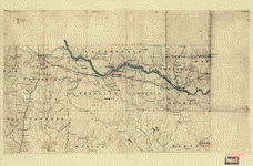 [Map of northwest Alabama and northeast Mississippi].
Site:
American Memory-cultural, Main Catalog
Original Format:
Map
Date:
1863
View catalog record
[Map of northwest Alabama and northeast Mississippi].
Site:
American Memory-cultural, Main Catalog
Original Format:
Map
Date:
1863
View catalog record
-
 [Northern Mississippi and Alabama]
Contributor:
Lindenkohl, A.
Site:
American Memory-cultural, Main Catalog
Original Format:
Map
Date:
1865
View catalog record
[Northern Mississippi and Alabama]
Contributor:
Lindenkohl, A.
Site:
American Memory-cultural, Main Catalog
Original Format:
Map
Date:
1865
View catalog record
-
 [Northern Mississippi and Alabama /
Contributor:
Lindenkohl, A.
Site:
American Memory-cultural, Main Catalog
Original Format:
Map
Date:
1865
View catalog record
[Northern Mississippi and Alabama /
Contributor:
Lindenkohl, A.
Site:
American Memory-cultural, Main Catalog
Original Format:
Map
Date:
1865
View catalog record
-
 Rebel line of works at Blakely : captured by the Army of West Miss., April 9, 1865 Position & approaches by the Union forces /
Contributor:
United States. Army. Corps of Engineers
Site:
American Memory-cultural, Main Catalog
Original Format:
Map
Date:
1865-04-09
View catalog record
Rebel line of works at Blakely : captured by the Army of West Miss., April 9, 1865 Position & approaches by the Union forces /
Contributor:
United States. Army. Corps of Engineers
Site:
American Memory-cultural, Main Catalog
Original Format:
Map
Date:
1865-04-09
View catalog record
-
 Rebel line of works at Blakely captured by the Army of West Miss., April 9, 1865
Contributor:
United States. Army. Corps of Engineers
Site:
American Memory-cultural, Main Catalog
Original Format:
Map
Date:
1865-04-09
View catalog record
Rebel line of works at Blakely captured by the Army of West Miss., April 9, 1865
Contributor:
United States. Army. Corps of Engineers
Site:
American Memory-cultural, Main Catalog
Original Format:
Map
Date:
1865-04-09
View catalog record
-
 Northern Mississippi and Alabama
Contributor:
Lindenkohl, A.
Site:
American Memory-cultural, Main Catalog
Original Format:
Map
Date:
1864
View catalog record
Northern Mississippi and Alabama
Contributor:
Lindenkohl, A.
Site:
American Memory-cultural, Main Catalog
Original Format:
Map
Date:
1864
View catalog record
-
 Northern Alabama and Georgia /
Contributor:
Lindenkohl, A.
Site:
American Memory-cultural, Main Catalog
Original Format:
Map
Date:
1864
View catalog record
Northern Alabama and Georgia /
Contributor:
Lindenkohl, A.
Site:
American Memory-cultural, Main Catalog
Original Format:
Map
Date:
1864
View catalog record
You might also like
-
 To the friends of our country. [Alabama 1824?]
Site:
American Memory-cultural
Original Format:
Book
Date:
1824
To the friends of our country. [Alabama 1824?]
Site:
American Memory-cultural
Original Format:
Book
Date:
1824
-
 Report of the committee appointed to examine the state bank. Jan. 8th, 1827.
Contributor:
Alabama. General Assembly. Committee appointed to examine the state bank
Site:
American Memory-cultural
Original Format:
Book
Date:
1827
Report of the committee appointed to examine the state bank. Jan. 8th, 1827.
Contributor:
Alabama. General Assembly. Committee appointed to examine the state bank
Site:
American Memory-cultural
Original Format:
Book
Date:
1827
-
 An abstract of the census of Alabama, taken in 1827.
Contributor:
Alabama. Census
Site:
American Memory-cultural
Original Format:
Book
Date:
1827
An abstract of the census of Alabama, taken in 1827.
Contributor:
Alabama. Census
Site:
American Memory-cultural
Original Format:
Book
Date:
1827
-
 A bill to be entitled an act to provide for the public safety. [s. l.]
Contributor:
Alabama. Laws. statutes, etc
Site:
American Memory-cultural
Original Format:
Book
Date:
1861
A bill to be entitled an act to provide for the public safety. [s. l.]
Contributor:
Alabama. Laws. statutes, etc
Site:
American Memory-cultural
Original Format:
Book
Date:
1861
-
 Military division of the West. October 17th, 1864.
Contributor:
Beauregard, G. T.
Site:
American Memory-cultural
Original Format:
Book
Date:
1864
Military division of the West. October 17th, 1864.
Contributor:
Beauregard, G. T.
Site:
American Memory-cultural
Original Format:
Book
Date:
1864
-
 Address of the Grand Council, U.L.A., to the councils of the Union League in Alabama [January 2, 1867].
Contributor:
Union League of Alabama. Grand Council
Site:
American Memory-cultural
Original Format:
Book
Date:
1867-01-02
Address of the Grand Council, U.L.A., to the councils of the Union League in Alabama [January 2, 1867].
Contributor:
Union League of Alabama. Grand Council
Site:
American Memory-cultural
Original Format:
Book
Date:
1867-01-02