Map
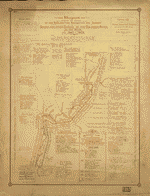
Diagram showing the history of the exploration and navigation and survey of the Grand and other canons of the Colorado River of the West from 1540 to 1908.
| Format |
Map |
|---|---|
| Contributors |
Stanton, Robert Brewster |
| Dates |
1908 |
| Location |
Colorado Colorado River Mexico United States |
| Language |
English |
| Subjects |
Colorado River (Colo.-Mexico) Discovery And Exploration Maps United States |
- Title
- Diagram showing the history of the exploration and navigation and survey of the Grand and other canons of the Colorado River of the West from 1540 to 1908.
- Description
-
Available also through the Library of Congress web site as a raster image.
-
1 map : col. ; 49 x 28 cm.
- Creator
- Stanton, Robert Brewster,
- Created Published
-
[S.l.], 1908.
- Subject Headings
-
-
Colorado River (Colo.-Mexico)--Discovery and Exploration--Maps.
-
-
United States--Colorado River (Colo.-Mexico)
- Notes
-
-
Available also through the Library of Congress web site as a raster image.
- Medium
-
1 map : col. ; 49 x 28 cm.
- Call Number
-
G4302.C6S12 1908 .S7 TIL
- Repository
-
Library of Congress Geography and Map Division Washington, D.C. 20540-4650 dcu
- Digital Id
-
g4302c np000054 http://hdl.loc.gov/loc.gmd/g4302c.np000054
- Library of Congress Catalog Number
- 99446133
Rights & Access
The maps in the Map Collections materials were either published prior to 1922, produced by the United States government, or both (see catalogue records that accompany each map for information regarding date of publication and source). The Library of Congress is providing access to these materials for educational and research purposes and is not aware of any U.S. copyright protection (see Title 17 of the United States Code) or any other restrictions in the Map Collection materials.
Note that the written permission of the copyright owners and/or other rights holders (such as publicity and/or privacy rights) is required for distribution, reproduction, or other use of protected items beyond that allowed by fair use or other statutory exemptions. Responsibility for making an independent legal assessment of an item and securing any necessary permissions ultimately rests with persons desiring to use the item.
More about Copyright and other Restrictions
For guidance about compiling full citations consult Citing Primary Sources.
Part of...
-
Mapping The National Parks
[170]
-
Additional Conservation And Environment Cartographic Items
[232]
-
Geography And Maps Division
[60803]
-
American Memory
[1121009]
More maps like this
-
 Rio Colorado of the West /
Contributor:
Ives, J. C.
Site:
American Memory-cultural, Main Catalog
Original Format:
Map
Date:
1858
View catalog record
Rio Colorado of the West /
Contributor:
Ives, J. C.
Site:
American Memory-cultural, Main Catalog
Original Format:
Map
Date:
1858
View catalog record
-
 Map of an exploring expedition to the Rocky Mountains in the year 1842 and to Oregon & North California in the years 1843-44 [] / ...
Contributor:
Fremont, John Charles
Site:
American Memory-cultural
Original Format:
Map
Date:
1845
Map of an exploring expedition to the Rocky Mountains in the year 1842 and to Oregon & North California in the years 1843-44 [] / ...
Contributor:
Fremont, John Charles
Site:
American Memory-cultural
Original Format:
Map
Date:
1845
-
 Map of the United States showing routes of principal explorers, from 1501 to 1844.
Contributor:
Bond, Frank
Site:
American Memory-cultural, Main Catalog
Original Format:
Map
Date:
1907
View catalog record
Map of the United States showing routes of principal explorers, from 1501 to 1844.
Contributor:
Bond, Frank
Site:
American Memory-cultural, Main Catalog
Original Format:
Map
Date:
1907
View catalog record
-
 Map of the Territory of New Mexico, 1846-7 [] / made by order of of Brig. Gen. S. W. Kearny, under instructions from Lieut. W.H. ...
Contributor:
Abert, James William
Site:
American Memory-cultural
Original Format:
Map
Date:
1847
Map of the Territory of New Mexico, 1846-7 [] / made by order of of Brig. Gen. S. W. Kearny, under instructions from Lieut. W.H. ...
Contributor:
Abert, James William
Site:
American Memory-cultural
Original Format:
Map
Date:
1847
-
 Map of an exploring expedition to the Rocky Mountains in the year 1842 and to Oregon & north California in the years 1843-44 /
Contributor:
Frémont, John Charles, Frémont, John Charles
Site:
American Memory-cultural, Main Catalog
Original Format:
Map
Date:
1845
View catalog record
Map of an exploring expedition to the Rocky Mountains in the year 1842 and to Oregon & north California in the years 1843-44 /
Contributor:
Frémont, John Charles, Frémont, John Charles
Site:
American Memory-cultural, Main Catalog
Original Format:
Map
Date:
1845
View catalog record
-
 Map of the territory west of the Rocky Mountains /
Contributor:
Bonneville, Benjamin Louis Eulalie de
Site:
American Memory-cultural, Main Catalog
Original Format:
Map
Date:
1837
View catalog record
Map of the territory west of the Rocky Mountains /
Contributor:
Bonneville, Benjamin Louis Eulalie de
Site:
American Memory-cultural, Main Catalog
Original Format:
Map
Date:
1837
View catalog record
-
 Map of an exploring expedition to the Rocky Mountains in the year 1842 and to Oregon & north California in the years 1843-44 /
Contributor:
Frémont, John Charles, Frémont, John Charles
Site:
American Memory-cultural, Main Catalog
Original Format:
Map
Date:
1845
View catalog record
Map of an exploring expedition to the Rocky Mountains in the year 1842 and to Oregon & north California in the years 1843-44 /
Contributor:
Frémont, John Charles, Frémont, John Charles
Site:
American Memory-cultural, Main Catalog
Original Format:
Map
Date:
1845
View catalog record
-
 [Map of the Peninsula of Florida].
Contributor:
Vinckeboons, Joan
Site:
American Memory-cultural, Main Catalog
Original Format:
Map
Date:
1639
View catalog record
[Map of the Peninsula of Florida].
Contributor:
Vinckeboons, Joan
Site:
American Memory-cultural, Main Catalog
Original Format:
Map
Date:
1639
View catalog record
-
 Country drained by the Mississippi western section []
Site:
American Memory-cultural
Original Format:
Map
Date:
1923
Country drained by the Mississippi western section []
Site:
American Memory-cultural
Original Format:
Map
Date:
1923
-
 Map of a reconnoisance between Fort Leavenworth on the Missouri river and the Great Salt Lake in the territory of Utah [], made in 1849 ...
Contributor:
United States. Army. Corps of Topographical Engineers
Site:
American Memory-cultural
Original Format:
Map
Date:
1850
Map of a reconnoisance between Fort Leavenworth on the Missouri river and the Great Salt Lake in the territory of Utah [], made in 1849 ...
Contributor:
United States. Army. Corps of Topographical Engineers
Site:
American Memory-cultural
Original Format:
Map
Date:
1850
-
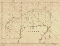 Discrección de la costa de Yucatan, Sonda de Campeche y baxos adjacentes segun su antigua situación con la derrota qe. practicaron en solicitud del Nombrado ...
Site:
American Memory-cultural, Main Catalog
Original Format:
Map
Date:
1700
View catalog record
Discrección de la costa de Yucatan, Sonda de Campeche y baxos adjacentes segun su antigua situación con la derrota qe. practicaron en solicitud del Nombrado ...
Site:
American Memory-cultural, Main Catalog
Original Format:
Map
Date:
1700
View catalog record
-
 Descripción de la costa de Yucatan, Sonda de Campeche y baxos adjacentes segun su antigua situación con la derrota que practcaron en solicitud del nombrado ...
Site:
American Memory-cultural, Main Catalog
Original Format:
Map
Date:
1700
View catalog record
Descripción de la costa de Yucatan, Sonda de Campeche y baxos adjacentes segun su antigua situación con la derrota que practcaron en solicitud del nombrado ...
Site:
American Memory-cultural, Main Catalog
Original Format:
Map
Date:
1700
View catalog record
-
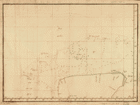 Discrección de la costa de Yucatan, Sonda de Campeche y bajos adjacentes segun su antigua situación con la derrota qe. practicaron en solicitud del Nombrado ...
Site:
American Memory-cultural, Main Catalog
Original Format:
Map
Date:
1700
View catalog record
Discrección de la costa de Yucatan, Sonda de Campeche y bajos adjacentes segun su antigua situación con la derrota qe. practicaron en solicitud del Nombrado ...
Site:
American Memory-cultural, Main Catalog
Original Format:
Map
Date:
1700
View catalog record
-
 Topographical map of the road from Missouri to Oregon, commencing at the mouth of the Kansas in the Missouri River and ending at the mouth ...
Contributor:
Fremont, John Charles
Site:
American Memory-cultural
Original Format:
Map
Date:
1846
Topographical map of the road from Missouri to Oregon, commencing at the mouth of the Kansas in the Missouri River and ending at the mouth ...
Contributor:
Fremont, John Charles
Site:
American Memory-cultural
Original Format:
Map
Date:
1846
-
 Boundaries between Brownsville, Texas and Matamoros, Tam. (Mexico)
Contributor:
International Boundary Commission, United States and Mexico
Site:
American Memory-cultural, Main Catalog
Original Format:
Map
Date:
1910
View catalog record
Boundaries between Brownsville, Texas and Matamoros, Tam. (Mexico)
Contributor:
International Boundary Commission, United States and Mexico
Site:
American Memory-cultural, Main Catalog
Original Format:
Map
Date:
1910
View catalog record
-
[Map of the Peninsula of Florida].
Contributor:
Vinckeboons, Joan
Site:
American Memory-cultural, Main Catalog
Original Format:
Map
Date:
1639
View catalog record
You might also like
-
 Exploration of the Colorado River of the West and its tributaries. Explored in 1869, 1870, 1871, and 1872, under the direction of the secretary of ...
Contributor:
Smithsonian Institution
Site:
American Memory-cultural
Original Format:
Book
Date:
1875
Exploration of the Colorado River of the West and its tributaries. Explored in 1869, 1870, 1871, and 1872, under the direction of the secretary of ...
Contributor:
Smithsonian Institution
Site:
American Memory-cultural
Original Format:
Book
Date:
1875
-
Report of the explorations in 1873 of the Colorado of the West and its tributaries,
Contributor:
Smithsonian Institution
Site:
American Memory-cultural
Original Format:
Book
Date:
1874
-
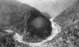 Canon of the Grand, Glenwood in distance
Contributor:
Dennis, A. W.
Site:
American Memory-cultural
Original Format:
Photo, Print, Drawing
Date:
1885
Canon of the Grand, Glenwood in distance
Contributor:
Dennis, A. W.
Site:
American Memory-cultural
Original Format:
Photo, Print, Drawing
Date:
1885
-
 Glenwood Springs
Contributor:
Dennis, A. W.
Site:
American Memory-cultural
Original Format:
Photo, Print, Drawing
Date:
1885
Glenwood Springs
Contributor:
Dennis, A. W.
Site:
American Memory-cultural
Original Format:
Photo, Print, Drawing
Date:
1885
-
 View above the Grand Falls
Contributor:
Dennis, A. W.
Site:
American Memory-cultural
Original Format:
Photo, Print, Drawing
Date:
1885
View above the Grand Falls
Contributor:
Dennis, A. W.
Site:
American Memory-cultural
Original Format:
Photo, Print, Drawing
Date:
1885
-
 View of the Canon the Grand
Contributor:
Dennis, A. W.
Site:
American Memory-cultural
Original Format:
Photo, Print, Drawing
Date:
1885
View of the Canon the Grand
Contributor:
Dennis, A. W.
Site:
American Memory-cultural
Original Format:
Photo, Print, Drawing
Date:
1885