Map
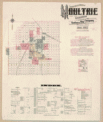
Sanborn Fire Insurance Map from Moultrie, Colquitt County, Georgia.
Views

| Format |
Map |
|---|---|
| Dates |
1920 |
| Location |
Colquitt County Georgia Moultrie |
| Language |
English |
- Title
- Sanborn Fire Insurance Map from Moultrie, Colquitt County, Georgia.
- Description
-
25 Sheet(s). Jun 1920.
- Created Published
- Sanborn Map Company, Jun 1920
- Notes
-
-
25 Sheet(s).
-
-
Jun 1920.
- Repository
- Library of Congress Geography and Map Division Washington, D.C. 20540-4650 USA
- Digital Id
-
http://www.loc.gov/item/sanborn01480_005
-
http://hdl.loc.gov/loc.gmd/g3924mm.01480005
Rights & Access
The maps in the Map Collections materials were either published prior to 1922, produced by the United States government, or both (see catalogue records that accompany each map for information regarding date of publication and source). The Library of Congress is providing access to these materials for educational and research purposes and is not aware of any U.S. copyright protection (see Title 17 of the United States Code) or any other restrictions in the Map Collection materials.
Note that the written permission of the copyright owners and/or other rights holders (such as publicity and/or privacy rights) is required for distribution, reproduction, or other use of protected items beyond that allowed by fair use or other statutory exemptions. Responsibility for making an independent legal assessment of an item and securing any necessary permissions ultimately rests with persons desiring to use the item.
More about Copyright and other Restrictions
For guidance about compiling full citations consult Citing Primary Sources.
Part of...
-
Sanborn Maps
[50014]
-
Geography And Maps Division
[60803]
-
American Memory
[1120703]
More maps like this
-
 Sanborn Fire Insurance Map from Moultrie, Colquitt County, Georgia.
Site:
American Memory-cultural
Original Format:
Map
Date:
1899-01-01
Sanborn Fire Insurance Map from Moultrie, Colquitt County, Georgia.
Site:
American Memory-cultural
Original Format:
Map
Date:
1899-01-01
-
 Sanborn Fire Insurance Map from Moultrie, Colquitt County, Georgia.
Site:
American Memory-cultural
Original Format:
Map
Date:
1903-01-01
Sanborn Fire Insurance Map from Moultrie, Colquitt County, Georgia.
Site:
American Memory-cultural
Original Format:
Map
Date:
1903-01-01
-
 Sanborn Fire Insurance Map from Moultrie, Colquitt County, Georgia.
Site:
American Memory-cultural
Original Format:
Map
Date:
1908-01-01
Sanborn Fire Insurance Map from Moultrie, Colquitt County, Georgia.
Site:
American Memory-cultural
Original Format:
Map
Date:
1908-01-01
-
 Sanborn Fire Insurance Map from Moultrie, Colquitt County, Georgia.
Site:
American Memory-cultural
Original Format:
Map
Date:
1912-01-01
Sanborn Fire Insurance Map from Moultrie, Colquitt County, Georgia.
Site:
American Memory-cultural
Original Format:
Map
Date:
1912-01-01
-

 Hargrett rare book and manuscript library rare map collection
Site:
Main Catalog
Original Format:
Map
Date:
2002
Hargrett rare book and manuscript library rare map collection
Site:
Main Catalog
Original Format:
Map
Date:
2002
-
 The State of Georgia, Civil War Centennial, 1864 : showing the major campaign areas and engagement sites of the Union and Confederate armies /
Contributor:
Georgia. State Highway Dept
Site:
American Memory-cultural, Main Catalog
Original Format:
Map
Date:
1964
View catalog record
The State of Georgia, Civil War Centennial, 1864 : showing the major campaign areas and engagement sites of the Union and Confederate armies /
Contributor:
Georgia. State Highway Dept
Site:
American Memory-cultural, Main Catalog
Original Format:
Map
Date:
1964
View catalog record
-
 The army map of Georgia.
Contributor:
Louis Prang and Company
Site:
American Memory-cultural, Main Catalog
Original Format:
Map
Date:
1864
View catalog record
The army map of Georgia.
Contributor:
Louis Prang and Company
Site:
American Memory-cultural, Main Catalog
Original Format:
Map
Date:
1864
View catalog record
-
 Map of army operations Atlanta campaign between Cassville and Mariette and vicinity
Contributor:
Western and Atlantic Railroad Company
Site:
American Memory-cultural, Main Catalog
Original Format:
Map
Date:
1864
View catalog record
Map of army operations Atlanta campaign between Cassville and Mariette and vicinity
Contributor:
Western and Atlantic Railroad Company
Site:
American Memory-cultural, Main Catalog
Original Format:
Map
Date:
1864
View catalog record
-
 Map[s] illustrating the military operations of the Atlanta campaign ... 1864 /
Site:
American Memory-cultural, Main Catalog
Original Format:
Map
Date:
1875
View catalog record
Map[s] illustrating the military operations of the Atlanta campaign ... 1864 /
Site:
American Memory-cultural, Main Catalog
Original Format:
Map
Date:
1875
View catalog record
-
 Northwestern Georgia (with portions of the adjoining States of Tennessee and Alabama) being part of the Department of the Cumberland.
Contributor:
Callahan, Denis
Site:
American Memory-cultural, Main Catalog
Original Format:
Map
Date:
1864
View catalog record
Northwestern Georgia (with portions of the adjoining States of Tennessee and Alabama) being part of the Department of the Cumberland.
Contributor:
Callahan, Denis
Site:
American Memory-cultural, Main Catalog
Original Format:
Map
Date:
1864
View catalog record
-
 Map illustrating the first epoch of the Atlanta Campaign : embracing the region from the Tennessee River to the Oostanaula River, showing the positions held ...
Contributor:
Ruger, Edward
Site:
American Memory-cultural, Main Catalog
Original Format:
Map
Date:
1974
View catalog record
Map illustrating the first epoch of the Atlanta Campaign : embracing the region from the Tennessee River to the Oostanaula River, showing the positions held ...
Contributor:
Ruger, Edward
Site:
American Memory-cultural, Main Catalog
Original Format:
Map
Date:
1974
View catalog record
-
 Northwestern Georgia (with portions of the adjoining States of Tennessee and Alabama) being part of the Department of the Cumberland /
Contributor:
Callahan, Denis
Site:
American Memory-cultural, Main Catalog
Original Format:
Map
Date:
1864
View catalog record
Northwestern Georgia (with portions of the adjoining States of Tennessee and Alabama) being part of the Department of the Cumberland /
Contributor:
Callahan, Denis
Site:
American Memory-cultural, Main Catalog
Original Format:
Map
Date:
1864
View catalog record
-
 The state of Georgia.
Site:
American Memory-cultural, Main Catalog
Original Format:
Map
Date:
1818
View catalog record
The state of Georgia.
Site:
American Memory-cultural, Main Catalog
Original Format:
Map
Date:
1818
View catalog record
-
 Map showing the operations of the national forces under the command of Maj. Gen. W.T. Sherman during the campaign resulting in the capture of Atlanta, ...
Contributor:
Hergesheimer, E.
Site:
American Memory-cultural, Main Catalog
Original Format:
Map
Date:
1864
View catalog record
Map showing the operations of the national forces under the command of Maj. Gen. W.T. Sherman during the campaign resulting in the capture of Atlanta, ...
Contributor:
Hergesheimer, E.
Site:
American Memory-cultural, Main Catalog
Original Format:
Map
Date:
1864
View catalog record
-
 Lloyd's topographical map of Georgia from state surveys before the war showing railways, stations, villages, mills, &c.
Contributor:
Lloyd, James T.
Site:
American Memory-cultural, Main Catalog
Original Format:
Map
Date:
1864
View catalog record
Lloyd's topographical map of Georgia from state surveys before the war showing railways, stations, villages, mills, &c.
Contributor:
Lloyd, James T.
Site:
American Memory-cultural, Main Catalog
Original Format:
Map
Date:
1864
View catalog record
-
 Part of northern Georgia /
Contributor:
Merrill, W. E.
Site:
American Memory-cultural, Main Catalog
Original Format:
Map
Date:
1864
View catalog record
Part of northern Georgia /
Contributor:
Merrill, W. E.
Site:
American Memory-cultural, Main Catalog
Original Format:
Map
Date:
1864
View catalog record
You might also like
-
 I'm gonna run for governor again
Site:
Prints & Photographs, Main Catalog
Original Format:
Photo, Print, Drawing
Date:
1942
View catalog record
I'm gonna run for governor again
Site:
Prints & Photographs, Main Catalog
Original Format:
Photo, Print, Drawing
Date:
1942
View catalog record
-
 [Composite of two photographs showing two men preparing mullets in large cooking vessels and several men cooking hush puppies, at campaign rally for Eugene Talmadge, ...
Site:
Prints & Photographs, Main Catalog
Original Format:
Photo, Print, Drawing
Date:
1942
View catalog record
[Composite of two photographs showing two men preparing mullets in large cooking vessels and several men cooking hush puppies, at campaign rally for Eugene Talmadge, ...
Site:
Prints & Photographs, Main Catalog
Original Format:
Photo, Print, Drawing
Date:
1942
View catalog record
-
 Dorothy M. Kibler VHP Collection
Contributor:
Kibler, Dorothy M.
Site:
Veterans History Project
Original Format:
Personal Narrative
Date:
2007-01-01
Dorothy M. Kibler VHP Collection
Contributor:
Kibler, Dorothy M.
Site:
Veterans History Project
Original Format:
Personal Narrative
Date:
2007-01-01
-
Richard L. Bedford VHP Collection
Contributor:
Bedford, Richard L.
Site:
Veterans History Project
Original Format:
Personal Narrative
Date:
2007-01-01
-
John Hunter VHP Collection
Contributor:
Hunter, John
Site:
Veterans History Project
Original Format:
Personal Narrative
Date:
2010
-
Judson Dewey Bullard, Jr. VHP Collection
Contributor:
Bullard Jr., Judson Dewey
Site:
Veterans History Project
Original Format:
Personal Narrative
Date:
2008-01-01