![[Plan of Fort Henry and its outworks.]](https://cybercemetery.unt.edu/archive/oilspill/20120921143507im_/http://www.loc.gov/collections/static/civil-war-maps/images/cw0414000.jpg)
![[Map of cavalry engagement near Bridgewater, Va. Oct. 4th and 5th, 1864]](https://cybercemetery.unt.edu/archive/oilspill/20120921143507im_/http://www.loc.gov/collections/static/hotchkiss-maps/images/cwh00193.jpg)
![[Rough sketch of the Rich Mountain battle area extending from Beverly, W. Va. to Clarksburg].](https://cybercemetery.unt.edu/archive/oilspill/20120921143507im_/http://www.loc.gov/collections/static/hotchkiss-maps/images/cwh00078.jpg)
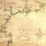
![Plano. I descripcion de la costa, desde el Cavo Cañaveral, hasta cerca de la boca de la Vir[g]inia, contando, costa de Florida, Georgia y Carolinas del S, y N, con todos sus puertos, este[ros ... ]letas, baxos, islas y rios; segun las vlti[mas not]icias, hata [sic] oy Octubre de 1756.](https://cybercemetery.unt.edu/archive/oilspill/20120921143507im_/http://www.loc.gov/collections/static/american-revolutionary-war-maps/images/ct000339.jpg)
![[December 21, 1944], HQ Twelfth Army Group situation map.](https://cybercemetery.unt.edu/archive/oilspill/20120921143507im_/http://www.loc.gov/collections/static/world-war-II-maps-military-situation-maps-from-1944-to-1945/images/ict21200.jpg)
![[Sketches of portions of Madison County, Va.].](https://cybercemetery.unt.edu/archive/oilspill/20120921143507im_/http://www.loc.gov/collections/static/hotchkiss-maps/images/cwh00106.jpg)
Results
-

North America, performed under the patronage of Louis Duke of Orleans, First Prince of the Blood;
Scale ca. 1:6,000,000.
Contributor: Bolton, Solomon Site: American Memory-cultural - Main Catalog Original Format: Map Date: 1752 View catalog record -

Carte generale de la terre : appliquée a l'astronomie pour l'etude de la géographie terrestre et celeste /
Relief shown pictorially.
Contributor: Flecheux, M. Site: American Memory-cultural - Main Catalog Original Format: Map Date: 1782 View catalog record -

Amérique septentrionale, suivant les nouvelles découvertes, augmenté des collonies qui sont derrière la Virginie et cour de l'Ohio. Traduit de l'anglois d'apres Thos. Gefferys géographe ...
Scale ca. 1:6,000,000.
Site: American Memory-cultural - Main Catalog Original Format: Map Date: 1757 View catalog record -

The new naval and military map of the United States /
Relief shown by hachures.
Contributor: Smith, J. Calvin Site: American Memory-cultural - Main Catalog Original Format: Map Date: 1862 View catalog record -

Mappa dell' America Settentrionale : ove sono rappresentati esattam. i paesi e loro limiti controversi che hanno dato motivo alla guerra presente fra la Francia ...
Shows eastern United States and southeastern Canada.
Contributor: Bellin, Jacques Nicolas Site: American Memory-cultural - Main Catalog Original Format: Map Date: 1758 View catalog record -

A general map of the middle British colonies in America: Viz. Virginia, Maryland, Delaware, Pensilvania, New-Jersey, New-York, Connecticut and Rhode-Island: Of Aquanishuonigy the country of ...
Hand colored.
Contributor: Gibson, J. Site: American Memory-cultural - Main Catalog Original Format: Map Date: 1758 View catalog record -
A new map of North America, from the latest discoveries 1778.
Scale ca. 1:15,000,000.
Contributor: Carver, Jonathan Site: American Memory-cultural - Main Catalog Original Format: Map Date: 1781 View catalog record -
An accurate map of North America describing and distinguishing the British and French dominions on this great continent according to the definitive treaty concluded at ...
Scale ca. 1:7,000,000.
Contributor: Sayer, Robert Site: American Memory-cultural - Main Catalog Original Format: Map Date: 1763 View catalog record -

Carte de la Nouvelle France,
Scale ca. 1:6,000,000.
Contributor: Thoreau, Henry David Site: American Memory-cultural - Main Catalog Original Format: Map Date: 1850 View catalog record -

Amplissima regionis Mississipi seu provinciæ Ludovicianæ â R.P. Ludovico Hennepin Francisc Miss. in America septentrionali anno 1687 detectæ, nunc Gallorum coloniis et actionum negotiis toto ...
Scale ca. 1:6,500,000.
Contributor: Homann, Johann Baptist Site: American Memory-cultural - Main Catalog Original Format: Map Date: 1763 View catalog record -


The integrated coastal management tool Catalog Record - Electronic Resource Available
System requirements: MS Windows OS; CD-ROM drive; Internet browser; ESRI® ArcGIS ArcMap 8.3 with spatial analyst extension.
Contributor: United States. National Oceanic and Atmospheric Administration Site: Main Catalog Original Format: Map Date: 2005 -

A new and accurate map of the English empire in North America; Representing their rightful claim as confirmed by charters and the formal surrender of ...
Scale ca. 1:7,200,000.
Contributor: Society of Anti-Gallicans Site: American Memory-cultural - Main Catalog Original Format: Map Date: 1755 View catalog record -

Carte des colonies anglaises dans l'Amérique septentrionale, terminée par la re. Ohio.
Scale ca. 1:5,400,000.
Contributor: Nolin, Jean Baptiste Site: American Memory-cultural - Main Catalog Original Format: Map Date: 1756 View catalog record -

Canada IIe. feuille, XXXV, B 32.
Scale ca. 1:10,500,000.
Contributor: Bonne, Rigobert Site: American Memory-cultural - Main Catalog Original Format: Map Date: 1776 View catalog record -

Map of the United States of America, the British Provinces, Mexico, the West Indies and Central America, with part of New Granada and Venezuela /
Wall map.
Contributor: Colton, G. Woolworth Site: American Memory-cultural - Main Catalog Original Format: Map Date: 1849 View catalog record -
An accurate map of North America. Describing and distinguishing the British, Spanish and French dominions on this great continent; according to the definitive treaty concluded ...
Scale ca. 1:550,000.
Contributor: Bowen, Emanuel Site: American Memory-cultural - Main Catalog Original Format: Map Date: 1763 View catalog record -

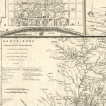
A new & accurate map of Louisiana, with part of Florida and Canada, and the adjacent countries.
Scale ca. 1:8,500,000.
Contributor: Bowen, Emanuel Site: American Memory-cultural - Main Catalog Original Format: Map Date: 1752 View catalog record -

A map of the British and French dominions in North America, with the roads, distances, limits, and extent of the settlements, humbly inscribed to the ...
Scale ca. 1:2,000,000.
Contributor: Mitchell, John Site: American Memory-cultural - Main Catalog Original Format: Map Date: 1774 View catalog record -
Canada IIe. feuille, XXXV, B 32.
Scale ca. 1:11,000,000.
Contributor: Bonne, Rigobert Site: American Memory-cultural - Main Catalog Original Format: Map Date: 1762 View catalog record -

North America.
Scale ca. 1:6,500,000.
Contributor: Jefferys, Thomas Site: American Memory-cultural - Main Catalog Original Format: Map Date: 1755 View catalog record