![[December 25, 1944], HQ Twelfth Army Group situation map.](https://cybercemetery.unt.edu/archive/oilspill/20120921144953im_/http://www.loc.gov/collections/static/world-war-II-maps-military-situation-maps-from-1944-to-1945/images/ict21204.jpg)
![[December 23, 1944], HQ Twelfth Army Group situation map.](https://cybercemetery.unt.edu/archive/oilspill/20120921144953im_/http://www.loc.gov/collections/static/world-war-II-maps-military-situation-maps-from-1944-to-1945/images/ict21202.jpg)
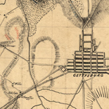
![[Sketch of the Manassas battlefield].](https://cybercemetery.unt.edu/archive/oilspill/20120921144953im_/http://www.loc.gov/collections/static/hotchkiss-maps/images/cwh00108.jpg)
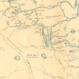
![[Map of cavalry engagement near Bridgewater, Va. Oct. 4th and 5th, 1864]](https://cybercemetery.unt.edu/archive/oilspill/20120921144953im_/http://www.loc.gov/collections/static/hotchkiss-maps/images/cwh00193.jpg)
![A map of the most inhabited part of New England... Thomas Jefferys, [London] Thos. Jefferys, 1755.](https://cybercemetery.unt.edu/archive/oilspill/20120921144953im_/http://www.loc.gov/collections/static/american-revolutionary-war-maps/images/ar079700.jpg)

Results
-


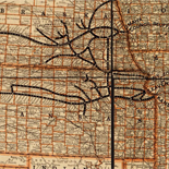
Map of Sonoma County, California : showing new boundary lines of county and townships, private claims and ranches, government townships and section lines, rail roads ... Catalog Record - Electronic Resource Available
Relief shown by hachures and spot heights.
Contributor: Thompson, R. A. Site: Main Catalog Original Format: Map Date: 1884 -

North America, performed under the patronage of Louis Duke of Orleans, First Prince of the Blood;
Scale ca. 1:6,000,000.
Contributor: Bolton, Solomon Site: American Memory-cultural - Main Catalog Original Format: Map Date: 1752 View catalog record -
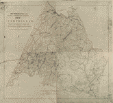
Map of Campbell Co.
LC Land ownership maps, 1229
Site: American Memory-cultural - Main Catalog Original Format: Map View catalog record -

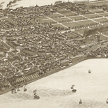
Bird's-eye view of Washington, D.C.--the nation's capital /
Low-angle view.
Contributor: Green, H. H. Site: American Memory-cultural - Main Catalog Original Format: Map Date: 1916 View catalog record -

Bell County /
Shows land ownership.
Contributor: Rosenberg, E. von Site: American Memory-cultural - Main Catalog Original Format: Map Date: 1919 View catalog record -
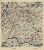
[May 22, 1945], HQ Twelfth Army Group situation map.
Available also through the Library of Congress web site as a raster image.
Contributor: Allied Forces. Army Group, 12th. Engineer Section Site: American Memory-cultural - Main Catalog Original Format: Map Date: 1945-05-22 View catalog record -

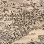
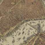
Panoramic view of the city of Ravenna, county seat of Portage Co., Ohio 1882.
Perspective map not drawn to scale.
Contributor: Ruger, A. Site: American Memory-cultural - Main Catalog Original Format: Map Date: 1882 View catalog record -

[November 17, 1944], HQ Twelfth Army Group situation map.
Available also through the Library of Congress web site as a raster image.
Contributor: Allied Forces. Army Group, 12th. Engineer Section Site: American Memory-cultural - Main Catalog Original Format: Map Date: 1944-11-17 View catalog record -

Sweden.
Includes note.
Contributor: United States. Central Intelligence Agency Site: American Memory-cultural - Main Catalog Original Format: Map Date: 1986 View catalog record -

[Survey of a tract of 9,138 acres of coal lands on the New River in Raleigh County, West Virginia, west of Quinnimont].
Pen-and-ink on tracing linen, mounted on cloth.
Site: American Memory-cultural - Main Catalog Original Format: Map View catalog record -
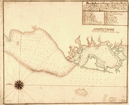
Plano del puerto de Cartagena de Yndias situado en la latitud N. 10 gros 30 minutos y en la longd. 298. gros y 15 ms. ...
Shows coast of Colombia in the region of Cartagena.
Contributor: Delgado y Gonzales, Gerónimo - Delgado y Gonzales, Gerónimo Site: American Memory-cultural - Main Catalog Original Format: Map Date: 1700 View catalog record -

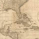
Spanish North America, southern part /
Relief shown by hachures.
Contributor: W. & D. Lizars Site: American Memory-cultural - Main Catalog Original Format: Map Date: 1816 View catalog record -

Salem, West Virginia 1899.
Perspective map not drawn to scale.
Contributor: Fowler, T. M. Site: American Memory-cultural - Main Catalog Original Format: Map Date: 1899 View catalog record -

[July 11, 1945], HQ Twelfth Army Group situation map.
Available also through the Library of Congress web site as a raster image.
Contributor: Allied Forces. Army Group, 12th. Engineer Section Site: American Memory-cultural - Main Catalog Original Format: Map Date: 1945-07-11 View catalog record -

Maoming xian yu tu.
Administrative map of Maoming in Guangdong Province.
Site: American Memory-cultural - Main Catalog Original Format: Map Date: 1821 View catalog record -

Ethiopia /
Relief shown by shading and spot heights.
Contributor: United States. Central Intelligence Agency Site: American Memory-cultural - Main Catalog Original Format: Map Date: 1976 View catalog record -

Vicksburg and vicinity.
Scale ca. 1:58,000.
Contributor: United States. Navy Site: American Memory-cultural - Main Catalog Original Format: Map Date: 1863 View catalog record -
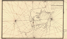
Plano de Puerto Cavello situado en la costa de Caracs. en lattd. de 10 gs. 26 ms. N. y en la longd. de 308 gs. ...
Shows coast of Venezuela in the region of Puerto Cabello.
Contributor: Hunttado Merittonis, Pedro Site: American Memory-cultural - Main Catalog Original Format: Map Date: 1784 View catalog record -

[Ming shi san ling tu].
Not drawn to scale.
Site: American Memory-cultural - Main Catalog Original Format: Map Date: 1875 View catalog record -

Chōsenkoku Gazankō ryakuzu : Sanmanbun no ichi /
Relief shown by hachures. Depths shown by soundings.
Contributor: Kaizu, Mitsuo Site: American Memory-cultural - Main Catalog Original Format: Map Date: 1879 View catalog record
Refine your search
Original Format
- Map
- Web Page [16]
Online Format
Date
Contributor
- United States. Central Intelligence Agency [1292]
- Allied Forces. Army Group, 12Th. Engineer Section [417]
- Fowler, T. M. [235]
- Ruger, A. [194]
- Texas. General Land Office [172]
- Burleigh, L. R. [134]
- G.W. & C.B. Colton & Co [130]
- Hotchkiss, Jedediah [126]
- United States Coast Survey [106]
- United States. National Park Service [83]
-
More Contributors