Skip Navigation Linksweather.gov 
NOAA logo - Click to go to the NOAA homepage National Weather Service Forecast Office   NWS logo - Click to go to the NWS homepage
Go to NWS Raleigh, NC Home


Local forecast by
"City, ST" or zip code
Top News of the Day (archive)
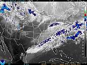
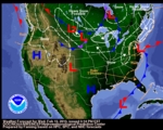
 Storm Total Snow Accumulation on February 16-17, 2013  Details....
 Latest snowfall reports  Details....
 Google map of latest snow reports for Central NC  Details....

Click on the map below for the latest forecast.
Last map update: Sun, Feb. 17, 2013 at 3:54:25 pm EST
Read watches, warnings & advisories
National Weather Service Blacksburg, VA National Weather Service Wakefield, VA
National Weather Service Greenville-Spartanburg, SC
Zoom
Out

National Weather Service Newport/Morehead City, NC
National Weather Service Columbia, SC National Weather Service Wilmington, NC
Gale Warning
Small Craft Advisory
Hazardous Weather Outlook

Quick Access to Text Products


Raleigh Radar
Raleigh Radar - Click to Enlarge

Satellite
Satellite image - Click to enlarge

Weather Map
Current Weather map - Click to enlarge

All Raleigh Text Products
All Raleigh Text Products - Click to Open

Hourly Weather
Forecast Graphs
Hourly Weather Forecast Graphs or Meteograms - Click to Open

Graphical Forecast
Graphical Forecast - Click to Open

Graphical Forecast Images
Graphical Forecast Images - Click to Open

Raleigh-Durham
Climate Plot
Raleigh-Durham Climate Plot - Click to Enlarge

Greensboro
Climate Plot
Greensboro Climate Plot - Click to enlarge

Fayetteville
Climate Plot
Fayetteville Climate Plot - Click to enlarge

24 Hour
Liquid
Precipitation Plot
24 Hour Liquid Precipitation Plot - Click to Enlarge

24 Hour
Maximum Temperature
Plot
24 Hour Maximum Temperature Precipitation Plot - Click to enlarge

24 Hour
Minimum Temperature
Plot
24 Hour Minimum Temperature Precipitation Plot - Click to enlarge

Current Hourly Weather Observations
Location Sky/Weather Temp.
(°F)
Dewpt.
(°F)
Humidity
(%)
Wind
(mph)
Pressure
(in)
Remarks
Greensboro Mostly Sunny 37 3 24 NW15G32 30.07F WCI28
Winston-Salem Sunny 37 1 22 NW18G26 30.08F WCI27
Raleigh-Durham Mostly Sunny 36 8 31 W12G24 30.10S WCI28
Fort Bragg Sunny 41 9 26 NW18G24 30.11F
Fayetteville Sunny 41 7 24 W17G29 30.12S
Burlington Sunny 37 10 32 W9G25 30.09S WCI30
Laurinburg Sunny 41 13 31 NW14G25 30.14S
Rocky Mount-Wilson Mostly Sunny 35 8 32 W12G25 30.10S WCI27
Goldsboro Sunny 37 8 29 NW15G31 30.08F WCI28
Hourly observations from: 300 PM EST SUN FEB 17 2013
Click on station name to see observations from the previous 48 hours


 On This Date in central North Carolina Weather History (search)...
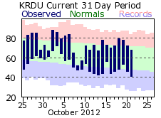
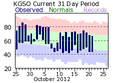
Greensboro reported a low of 0 on February 17, 1958. Greensboro observes the coldest February high temperature when temperature only reached 15 degrees on February 17, 1958.


National Weather Service
Raleigh Forecast Office
1005 Capability Drive, Suite 300
Centennial Campus
Raleigh, North Carolina 27606-5226
(919) 515-8209
Page author: 
Web Master's E-mail:  rah.webmaster@noaa.gov
Page Last Modified: 09 November 2012 12:05:55 UTC


USA.gov
Disclaimer
Credits
Glossary
Information Quality
FOIA
Privacy Policy
About Us
Career Opportunities