
Agricultural Weather and Drought Update – 10/3/12
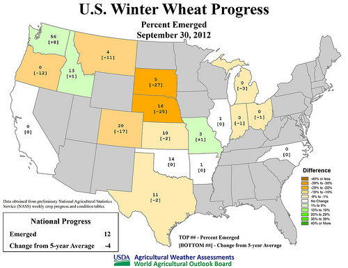
U.S. Winter Wheat Progress - Percent emerged September 30, 2012. Click to enlarge image.
Based on data since 1995, U.S. corn and soybean harvests are proceeding at a record pace. By September 30, 2012, more than one-half (54%) of the corn had been harvested, nearly three times the five-year average of 20%. During the preceding 17 years, the record amount of U.S. corn harvested by the end of September had been 35% in 2000. Similarly, 41% of the soybeans had been harvested by September 30. Prior to this year, the record-setting soybean harvest pace by September 30 had also been 35% in 2000.
With autumn underway, the historic drought of 2012 has shifted northwestward but continues to cover nearly two-thirds of the contiguous U.S. In fact, drought covered 65.45% of the Lower 48 states on September 25, a record during the 13-year history of the U.S. Drought Monitor. The summer 2012 peak of U.S. drought coverage had been 63.86% on July 24.
The new center of the U.S. drought is the northwestern half of the Plains. Until October 2-3, when rain and snow showers associated with a strong cold front engulfed parts of Montana and North Dakota, impressive dry spells were noted across the northern Plains. For example, Great Falls, Montana, endured 47 consecutive days (August 16 – October 1) without measurable precipitation, representing the second-longest such streak in that location behind a 62-day dry spell from October 7 – December 7, 1907. Similarly, Sheridan, Wyoming, set an all-time record with 53 consecutive days (August 11 – October 2) without measurable precipitation. Sheridan’s previous record had been set during a 46-day dry spell from December 5, 2002 – January 19, 2003.
Primary impacts of the northern Plains’ dry spell have included deterioration of rangeland and pasture conditions and delayed winter wheat emergence. By September 30, nearly all (98%) of Nebraska’s rangeland and pastures were rated in very poor to poor condition, according to USDA’s National Agricultural Statistics Service. Rangeland and pasture conditions were nearly as abysmal in Wyoming (87% very poor to poor), Colorado (85%), South Dakota (78%), and Montana (78%).
Meanwhile, September 30 reports regarding U.S. winter wheat indicated that emergence was at least ten percentage points behind the five-year average pace in South Dakota (5% emerged versus the average of 32%), Nebraska (16 vs. 41%), Colorado (20 vs. 37%), Montana (4 vs. 15%), and Oregon (0 vs. 12%), reflecting the extremely dry conditions. In contrast, last week’s generous rains have helped rangeland, pastures, and recently planted winter wheat from the southern half of the Plains into the Ohio Valley.
Weather Outlook: For the remainder of the week, cold air will engulf the Plains and Midwest, and eventually blanket most of the U.S. During the weekend, freezes can be expected as far south as the southern Plains and the mid-South. Meanwhile, lingering warmth will be confined to the Far West and the lower Southeast. Elsewhere, dry conditions will persist west of the Rockies, while snow will gradually end across the north-central U.S., from Montana to northern Minnesota. Looking ahead to next week, near- to below-normal temperatures will prevail nationwide, except for warmer-than-normal weather in southern Texas and the Pacific Northwest. Meanwhile, near- to below-normal precipitation across the majority of the U.S. will contrast with wetter-than-normal conditions in Florida, southern portions of the Rockies and High Plains, and from the lower Great Lakes region into the Northeast.
Tags: drought, Environment, NASS, weather update