mcpeaks
BLM
U.S. DEPARTMENT OF THE INTERIOR
BUREAU OF LAND MANAGEMENT
Rock art near Worland, Wyoming. Scenery along the Red Gulch-Alkali Backcountry Byway near Worland, Wyoming. Duck Swamp Interpretive Area near Worland, Wyoming. Scenery in the Gooseberry Badlands near Worland, Wyoming. Dinosaur track at the Red Gulch Dinosaur Tracksite near Worland, Wyoming.
Wyoming
BLM>Wyoming>Field Offices>Worland
Print Page

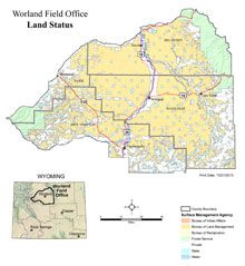
Worland Field Office

Connect with BLM Wyoming

 BLM Wyoming Twitter.

BLM Wyoming Facebook.

BLM Wyoming Flickr.

BLM Wyoming YouTube.

BLM WY Newsrelease RSS Feed.

Worland FO Links

Field Office Map

Bighorn Basin RMP

Dinosaur Tracksite

Fire & Fuels
 > Fire Restrictions 

Grazing

Maps

Minerals

NEPA Documents - upd. 09/19/12

NEPA Register

Oil & Gas

Planning

Rangeland Health 

Recreation

Resource Advisory Council

Wild Horses

Wilderness Study Areas
Worland Field Office land status map.
The Worland Field Office
manages more than two million acres of public lands in the southern half of the Bighorn Basin. Located in northcentral Wyoming, these lands provide a variety of resources and uses including wild horses, wildlife habitat, scenic vistas, recreation opportunities, mineral development and livestock grazing.

You can mountain bike, horseback ride, hunt big game, fish a blue-ribbon trout stream, explore the badlands, see the latest dinosaur discoveries, and more! So when you come to Wyoming, visit the Bighorn Basin and enjoy America's public lands!

In the Spotlight


Documents


Worland Field Office  101 South 23rd  |  Worland, WY 82401

Phone: 307-347-5100  |  Fax: 307-347-5228  |  Office hours: 7:45am - 4:30pm M-F