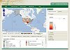
Current U.S. Drought Monitor
|
The data cutoff for Drought Monitor maps is Tuesday at 7 a.m. Eastern Standard Time. The maps, which are based on analysis of the data, are released each Thursday at 8:30 a.m. Eastern Time. NOTE: To view regional drought conditions, click on map below. State maps can be accessed from regional maps. |

The U.S. Drought Monitor is produced in partnership between the National Drought Mitigation Center at the University of Nebraska-Lincoln, the United States Department of Agriculture, and the National Oceanic and Atmospheric Administration.
UPDATE: The links have been moved into the menu bars below.
NDMC's Drought Impact Reporter |
6-week animation |
12-week animation |
Custom DM animation |
short-term drought indicator blends |
long-term drought indicator blends |
 |
 |
 |
 |
 |
 |
For local details and impacts, please contact your State Climatologist or Regional Climate Center.
| The discussion in the Looking Ahead section is simply a description of what the official national guidance from the National Weather Service (NWS) National Centers for Environmental Prediction is depicting for current areas of dryness and drought. The NWS forecast products utilized include the HPC 5-day QPF and 5-day Mean Temperature progs, the 6-10 Day Outlooks of Temperature and Precipitation Probability, and the 8-14 Day Outlooks of Temperature and Precipitation Probability, valid as of late Wednesday afternoon of the USDM release week. The NWS forecast web page used for this section is: http://www.cpc.ncep.noaa.gov/products/forecasts/. Weekly Summary: During the past week, a slow-moving front sank southeastward across the eastern two-thirds of the contiguous United States. A wave of low pressure formed along the front in west-central Texas near the Edwards Plateau, resulting in widespread heavy tropical rains for much of the southern Plains, the lower Mississippi Valley, and the interior Southeast. Heavy rain (2 inches or greater) also fell over the Ohio and Tennessee Valleys, southern Illinois, eastern Missouri, and the interior mid-Atlantic region. The Upper Midwest, northern half of the Great Plains, and the West received little to no precipitation during the past 7-days. Temperatures for the period were generally above normal in the West (as much as 8 degrees above normal in the northern High Plains), 2-4 degrees below normal in the Great Lakes, Northeast, and Ohio Valley, and 2-4 degrees above normal in the Southeast. The Northeast and mid-Atlantic: During the past week, most areas received light to moderate rain (up to 2 inches), with heavy rain (2 inches or greater) observed over northern and extreme southwestern Virginia, southwestern and south-central Pennsylvania, southern West Virginia, and parts of New England. Abnormally dry (D0) conditions were removed from West Virginia, and from Fayette County in southwestern Pennsylvania. One-category improvements were made in west-central and eastern New York, and in parts of northern Virginia. For the southern Delmarva Peninsula, Accomack, Somerset, and Worchester Counties were upgraded from D1 to D0 based on AHPS Departure from Normal Precipitation (DNP) at 180-, 90-, and 60-days. The Ohio Valley: Heavy rain (2 inches or greater) fell over northern and eastern Ohio, southern Indiana, and much of Kentucky. Near to above-normal stream flows contributed to 1-category upgrades across portions of the region. Louisville, Kentucky’s 5.83 inches of rain resulted in their 9th wettest September on record. In Ohio, D2 conditions were removed from southwestern parts of the state, and trimmed back in south-central portions of the state. The Southeast: East-central Alabama, northern and western Georgia, western portions of both North and South Carolina, and Tennessee received in excess of 2 inches of rain during the past week, prompting 1-category improvements to some areas, especially across approximately the northwest half of Georgia. Some of these locales in north-central and northeastern Georgia received as much as 8 inches of rain. The Upper Great Lakes and Midwest: Little if any precipitation fell over Minnesota, Iowa, Wisconsin, Upper Michigan, northern Illinois and portions of northern Missouri during the past 7-days. Widespread 1-category degradations were made in the region. Some of the more extensive changes involved expansion of moderate drought (D1) conditions across northern Minnesota, and much of north-central and northeastern Wisconsin. Low stream flows and 60-day DNPs lend support for these degradations. In contrast, 1-category improvements were rendered to the drought depiction over southern Illinois and eastern Missouri including the St. Louis area. The lower Mississippi/Delta area: Though Louisiana and Mississippi received in excess of 2 inches of rain in association with the low pressure area that developed over Texas, the only alteration made at this time was to remove the D3 designation over northwestern Mississippi. The Northern Plains: Very dry weather continues to prevail across the northern Great Plains, prompting extensive 1-category downgrades across a large portion of North Dakota. Severe drought (D2) was expanded to include most of the eastern half of the state, and D2 was also expanded eastward across the Canadian border counties as far east as Rolette County. In the heart of the state, D0 conditions were downgraded to D1. In South Dakota, exceptional drought (D4) was expanded throughout the southwestern portion of the state, and severe drought (D2) was expanded throughout the northwestern portion of the state in keeping with the prevailing dryness. These expansions also pushed D4 and D2 conditions into eastern Wyoming and extreme southeastern Montana, respectively. The Central and Southern Plains: The stalled front and associated wave of low pressure that developed along it last week brought beneficial, widespread rains to the southern Great Plains. Many locations in Texas and in the southern half of Oklahoma received heavy precipitation (2 inches or greater). As a result, extensive 1-category upgrades were made to the regional drought depiction. Significant runoff occurred for the first time in over two years in west-central areas of Texas. In Oklahoma, 1-category improvements were made across much of the state, including portions of the Panhandle, while D4 conditions were expanded eastward across northern Oklahoma where little rain fell this past week. Farther north in Kansas, a one-category downgrade from D2 to D3 conditions was made across northeastern and north-central sections of the state due to lack of rain and surface water shortages. However, in eastern areas of Kansas, one-category improvements were rendered to the depiction due to recent rains and improved stream flows. The Rockies: The only revisions made this week were in Colorado, where 1-category improvements were made to north-central and extreme southeastern portions of the state. The Southwest: No changes were made to the regional depiction this week. The Pacific Northwest: Abnormal dryness (D0) was expanded across western portions of Oregon. At this time, it appears that the onset of the climatological rainy season will be delayed somewhat. Alaska, Hawaii, and Puerto Rico: One-category improvements were made to northeastern portions of Oahu and Maui where respectable rains fell (1.5 to 3.5 inches), and an expansion of D0 conditions was rendered to southwest portions of the Big Island of Hawaii where little if any rain fell. The depiction for both Alaska and Puerto Rico remain unchanged at this time. Looking Ahead: In the ensuing 5 days, a fairly dry period is in store for much of the lower 48 states. Exceptions would include the eastern margin of the Eastern CONUS drought area, from Arkansas northeast to New York, where 1-2 inches of rain is expected, and also in North Dakota and far northern Minnesota, where 1-2 inches of rain is predicted. The CPC 6-10 day Precipitation Outlook projects elevated odds of above-median precipitation from the eastern Great Lakes region, the Northeast and mid-Atlantic southwestward to the Southwest, as well as for most of Alaska (excluding the Panhandle). The odds for below-median precipitation are enhanced across the western Gulf Coast states including eastern Texas, the northwestern quarter of the CONUS, and the Alaska Panhandle. |
| Dryness Categories |
| D0 ... Abnormally Dry ... used for areas showing dryness but not yet in drought, or for areas recovering from drought.
Updated October 3, 2012 |


)