- Current Hazards
- Forecasts
- Current Weather
- Radar Imagery
- Climate
- Weather Safety
- Additional Info
- Contact us
Aviation Weather
Tactical Decision Aid
| The Terminal Aerodrome Forecasts (TAF) is used by our partners in the aviation community to make critical decisions across the National Air Space. The Tactical Decision Aid (TDA) presents the TAF in an easy to read format. The program also displays the current observations and the forecast conditions over the next 12 hours for the specified airport. This service is courtesy of Eric Avila at the Center Weather Service Unit in Houston, TX. |
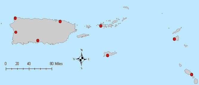
Click on Map Below for TAF Forecasts
Click on a red dot for the TAF at that location.
Local Surface Observations
- San Juan, Puerto Rico (Luis Munoz Marin International Airport)
- Roosevelt Roads/Ceiba, Puerto Rico (Former Naval Station, Ofstie Field)
- Ponce, Puerto Rico (Mercedita Airport)
- Aguadilla, Puerto Rico (Rafael Hernandez Airport)
- Eugenio Maria de Hostos, Puerto Rico (Mayaguez Airport)
- Charlotte Amalie, St. Thomas, U.S. Virgin Islands (Cyril E. King Airport)
- Christiansted, St. Croix, U.S. Virgin Islands (Henry E. Rohlsen Airport)
- Beef Island, Tortola, British Virgin Islands
- Golden Rock, St. Kitts and Nevis
- St. Maarten, Netherlands Antilles (Juliana Airport)
Local Upper Air Observations
Local Aviation Climatology
Additional Resources
- National Weather Service
- San Juan, PR Weather Forecast Office
- 4000 Carretera 190
- Carolina, PR 00979
- 787-253-4586
- Page Author: SJU Webmaster
- Web Master's E-mail: sr-sju.webmaster@noaa.gov
- Page last modified: January 15th 2012 12:03 PM