Blog Articles By Category

Main Content

What We're Watching: 9/14/12

Author: 

At the end of each week, we post a "What We’re Watching" blog as we look ahead to the weekend and recap events from the week. We encourage you to share it with your friends and family, and have a safe weekend.

Weather outlook
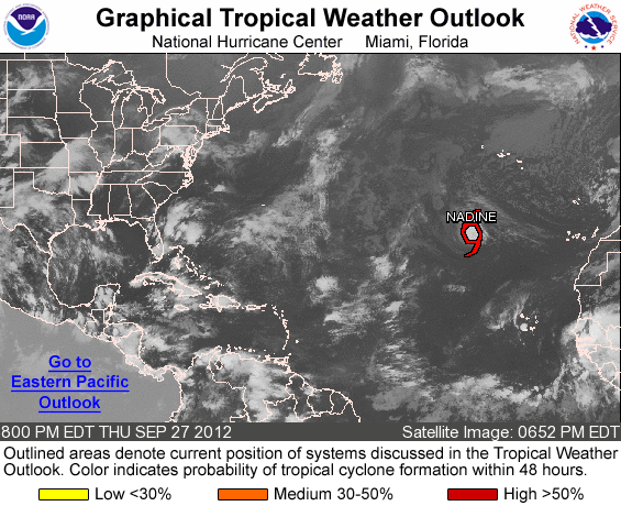
As summer starts to fade into fall in some areas of the country, we continue to closely watch the tropics.  As you know, we are currently at the peak of the Atlantic hurricane season, and the season continues until November 30. Currently, tropical storm Nadine is swirling in the Atlantic ocean and poses no threat to the U.S. or its territories. Keep up with the latest tropical forecast from the National Hurricane Center at www.hurricanes.gov or on your phone at http://hurricanes.gov/mobile.

And if you live in a coastal or inland area that could be affected by hurricanes or tropical storms, now's the time to prepare - visit www.Ready.gov/hurricanes or m.fema.gov on your phone to learn how.


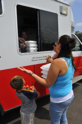
Isaac recovery continues

disaster recovery center
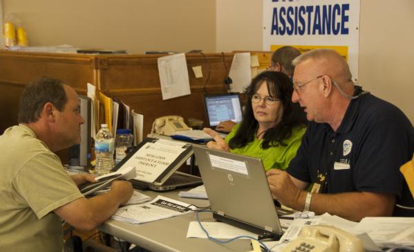
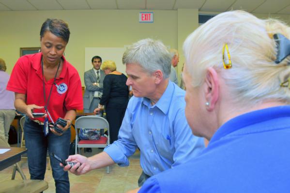
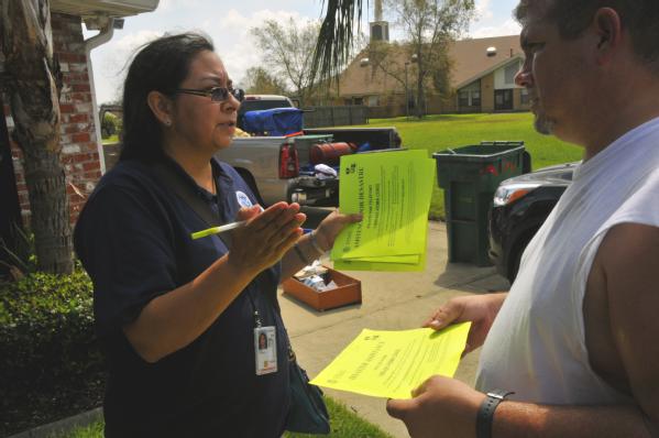
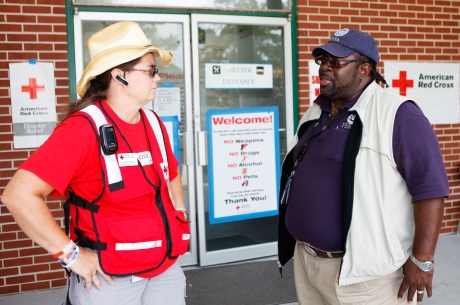
LaPlace, La., Sep. 11, 2012 – A FEMA Mitigation specialist talks to a Hurricane Isaac survivor in a Disaster Recovery Center. FEMA Mitigation specialists are assisting homeowners by providing them with information they need to rebuild their damaged property.


We continue to work closely with our state, local, and tribal partners as we assist those affected by Hurricane Isaac in Mississippi and Louisiana. Thousands have applied for disaster assistance so far, and Disaster Recovery Centers set up in the affected area continue to provide recovery information to disaster survivors. Earlier this week, we posted some stats about how Isaac survivors are applying for disaster assistance - I encourage you to check it out. The disaster pages for Louisiana and Mississippi have the latest information on FEMA's role in the recovery.


The excitement of graduation

fema corps graduation
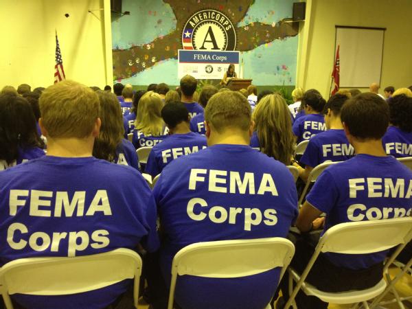
Vicksburg, Miss., Sep. 13, 2012 -- Induction Ceremony for the inaugural class of FEMA Corps members. FEMA Corps members assist with disaster preparedness, response, and recovery activities, providing support in areas ranging from working directly with disaster survivors to supporting disaster recovering centers to sharing valuable disaster preparedness and mitigation information with the public. 


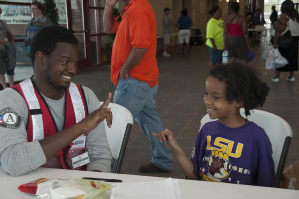
Lastly, all of us at FEMA are excited about the first class of FEMA Corps graduates that were newly minted earlier this week. FEMA Corps is a program that combines the expertise of FEMA and AmeriCorps to equip groups of young people to deploy into areas affected by disasters and assist the community with recovery. The new members, who range in age from 18-24 years old, will contribute to a dedicated, trained, and reliable disaster workforce by working full-time for ten months on federal disaster response and recovery efforts.

FEMA Deputy Administrator Rich Serino spoke to the class of 231 graduates yesterday, and he blogged about his perspective on the FEMA Corps program as well.

Have a great weekend!

What We’re Watching: 9/7/12

Author: 

At the end of each week, we post a "What We’re Watching" blog as we look ahead to the weekend and recap events from the week. We encourage you to share it with your friends and family, and have a safe weekend.

Weather Outlook

Our partners at the National Weather Service continue to monitor tropical weather activity, specifically a low pressure system that is producing overcast and some rain along the Gulf Coast.  Although this system has a low chance of becoming a tropical cyclone, we will also continue to monitor weather conditions.

We are also monitoring Tropical Storm Leslie and Hurricane Michael in the Atlantic, although both of these storms are not expected to impact the U.S at this time.

Stay up to date with the latest forecast from the NOAA National Hurricane Center at hurricanes.gov or on your phone at hurricanes.gov/mobile. For updates on the local weather in your area, visit weather.gov or m.weather.gov on your phone.

Hurricane Isaac Photo Recap

As we continue our recovery efforts following the aftermath of Hurricane Isaac, we wanted to share some photos from the past couple of days highlighting the great work being done by federal, state, tribal, and local government agencies, community and faith-based organizations, non-profit organizations, and the private sector to assist survivors as they recover from the storm. 

LaPlace, La., Sep. 5, 2012 -- Jamaal Johnson, an AmeriCorp volunteer teaches a child sign language at the St. John's Baptist Community Center where a temporary shelter has been set up for Hurricane Isaac survivors. FEMA is working with local, state and federal agencies to provide services for residents affected by Hurricane Isaac.

LaPlace, La., Sep. 5, 2012 -- Jamaal Johnson, an AmeriCorp volunteer teaches a child sign language at the St. John's Baptist Community Center where a temporary shelter has been set up for Hurricane Isaac survivors. FEMA is working with local, state and federal agencies to provide services for residents affected by Hurricane Isaac.

LaPlace, La., Sep. 5, 2012 -- A family of Hurricane Isaac survivors from LaPlace, La. grab a meal from the Red Cross at a distribution center. This group of volunteers came from Houston to help those affected by Hurricane Isaac.

LaPlace, La., Sep. 5, 2012 -- A family of Hurricane Isaac survivors from LaPlace, La. grab a meal from the Red Cross at a distribution center. This group of volunteers came from Houston to help those affected by Hurricane Isaac.


LaPlace, La., Sep. 4, 2012 -- Roger Bostic, left, and Raynell Parker McNeil bag laundry for washing, drying, and folding for a family affected by Hurricane Isaac. Hundreds in LaPlace, La affected by Hurricane Isaac have taken advantage of the service provided by Tide at no charge.

LaPlace, La., Sep. 4, 2012 -- Roger Bostic, left, and Raynell Parker McNeil bag laundry for washing, drying, and folding for a family affected by Hurricane Isaac. Hundreds in LaPlace, La affected by Hurricane Isaac have taken advantage of the service provided by Tide at no charge.

Pascagoula, Miss., Sep. 5, 2012 -- A survivor of Hurricane Isaac completes the application for disaster assistance with a representative of the Small Business Administration. Disaster Recovery Centers have all the representatives of state and federal agencies to assist applicants.

Pascagoula, Miss., Sep. 5, 2012 -- A survivor of Hurricane Isaac completes the application for disaster assistance with a representative of the Small Business Administration. Disaster Recovery Centers have all the representatives of state and federal agencies to assist applicants.

French Settlement, La., Sep. 5, 2012 -- Applicant Services Specialists, Teia Beaulieu, left, and U.S. Congressman Bill Cassidy, M.D., Sixth District of Louisiana, compare signal strength on their cell phone while helping a woman affect by Hurricane Isaac call to register for assistance. Congressman Cassidy requested that FEMA representatives attend the town hall meeting in French Settlement, La. to take questions and provided information to the community.

French Settlement, La., Sep. 5, 2012 -- Applicant Services Specialists, Teia Beaulieu, left, and U.S. Congressman Bill Cassidy, M.D., Sixth District of Louisiana, compare signal strength on their cell phone while helping a woman affect by Hurricane Isaac call to register for assistance. Congressman Cassidy requested that FEMA representatives attend the town hall meeting in French Settlement, La. to take questions and provided information to the community.

La Place, La., Sep. 3, 2012 -- Community Relations Specialist, Patricia "Alley" West, (left) goes door to door in neighborhoods affected by Hurricane Isaac handing out flyers and providing information to assist residents who may qualify for FEMA assistance. Areas in La Place flooded when the slow moving storm passed through.

La Place, La., Sep. 3, 2012 -- Community Relations Specialist, Patricia "Alley" West, (left) goes door to door in neighborhoods affected by Hurricane Isaac handing out flyers and providing information to assist residents who may qualify for FEMA assistance. Areas in La Place flooded when the slow moving storm passed through.

Orleans Parish, La., Sep. 3, 2012 -- Volunteers are working to remove debris from neighborhoods which impacted by during Hurricane Isaac movement through the area.

Orleans Parish, La., Sep. 3, 2012 -- Volunteers are working to remove debris from neighborhoods which impacted by during Hurricane Isaac movement through the area.

For more information on how you can assist survivors of Hurricane Isaac, visit www.fema.gov/volunteer-donate-responsibly.

National Preparedness Month

We are officially one week into National Preparedness Month -- but it’s not too late to pledge to prepare and take the necessary steps to get yourself, family, friends, coworkers, and community prepared for an emergency.  The goal of National Preparedness Month is to encourage individuals, businesses, government agencies, and nonprofit organizations to learn about the local hazards in your community, make a family communication plan, build an emergency kit, then get involved in your local community preparedness efforts.

The first step to getting involved in National Preparedness Month is registering as a coalition member at Ready.gov/pledge.  There you will join a community of thousands of individuals, emergency management professionals, businesses, and voluntary and faith-based groups, sharing emergency preparedness information and events, resources, and tools available to help get you prepared for an emergency and spreading preparedness in your own community.

We hope that you will join us and help promote a culture of preparedness by becoming a coalition member and pledging to prepare this September for NPM.

Have a great weekend!


What We’re Watching: 8/17/12

Author: 

At the end of each week, we post a "What We’re Watching" blog as we look ahead to the weekend and recap events from the week. We encourage you to share it with your friends and family, and have a safe weekend.

Weather Outlook

Looking ahead to the weekend, National Weather Service forecasts are calling for somewhat minimal thunderstorm activity across the U.S.  However, severe drought conditions are expected to continue for much of the country through next week. At FEMA, we are supporting our federal and state partners – and following the lead of the Department of Agriculture as they coordinate assistance to farmers and ranchers affected by the drought.

And of course, we continue to closely monitor the Atlantic for any potential tropical storm or hurricane activity. You can always follow the latest forecast from the NOAA National Hurricane Center at hurricanes.gov or on your phone at hurricanes.gov/mobile. Make sure you know what to do before, during, and after severe tropical weather by visiting Ready.gov/hurricanes.

National Preparedness Month Approaching

It’s almost that time of year! September 1 marks the beginning of National Preparedness Month. The theme for NPM 2012 is Pledge to Prepare – Awareness to Action.  This year we are encouraging individuals, businesses, government agencies, and nonprofit organizations to:

There’s an easy first step to getting involved in National Preparedness Month – register as a coalition member at Ready.gov/pledge.  As a Coalition members, you’ll join a community of thousands of individuals, emergency management professionals, businesses, and voluntary and faith-based groups, sharing emergency preparedness information and events so that everyone can be better prepared before a disaster strikes.  Members can also take advantage of the online community, resources, and tools available to help get you prepared for an emergency and spread NPM during September.

Have a safe and enjoyable weekend!

What We’re Watching: 8/10/12

Author: 

At the end of each week, we post a "What We’re Watching" blog as we look ahead to the weekend and recap events from the week. We encourage you to share it with your friends and family, and have a safe weekend.

We’re in a visual mood at FEMA today, so this week’s What We’re Watching is done primarily “in pictures”:

Severe Weather Outlook

Going into next week, National Weather Service forecasts are calling for the severe drought conditions to continue for much for the U.S., as high temperatures will affect portions of central U.S.  If your area may experience summer heat next week, visit Ready.gov/heat for tips on staying cool.   For those dealing with the prolonged, extreme drought, make sure to follow any local restrictions on water use and visit the U.S. Department of Agriculture website for information on the federal government’s assistance to farmers and ranchers.

severe weather outlook

Tropical activity heating up

Along with our partners at the NOAA National Hurricane Center, we are closely monitoring several areas of organized storm activity in the Atlantic basin (shown below).  Tropical depression #7 is likely to develop into a named tropical storm this weekend and those in the U.S. Virgin Islands and Puerto Rico should keep a close watch on its development.

tropical weather outlook


The image below (also from the National Hurricane Center) shows the probability of tropical storm force winds in the areas that may be affected by tropical depression #7 today through August 15. As you can see, the U.S. Virgin Islands and Puerto Rico should closely monitor this system through local media or by visiting the National Hurricane Center full and mobile websites. Tropical storm force winds have an average speed of greater than 39 mph per minute.

(Editor's note: image removed on August 14)

Job opportunities at FEMA

Alright, the “visual” theme doesn’t apply to this section, but there are several open positions at FEMA right now.  I encourage you to visit our careers page to learn more about working at FEMA or search for current openings now at USAjobs.gov.  Here are two openings I wanted to highlight:

  • Management Analyst, Denton, Texas - ideal for a candidate who has extensive experience analyzing disaster assistance programs and providing expert advice to  key senior managers at the federal, state and local level. 
  • Training Specialist, Center for Domestic Preparedness, Anniston, Ala. - Provide oversight for daily operational and administrative aspects of an emergency responder training program.


Historical hurricane activity

Yesterday on the NOAA Facebook page, they posted this colorful photo showing the historical hurricane and tropical storm activity in the continental U.S.  Each color signifies a different intensity of storm, and you can research how many hurricanes and tropical storms have impacted your community with NOAA’s new “Digital Coast” tool.

The colors below can be dizzying, but it shows that hurricanes and tropical storms impact both coastal and inland areas.  Make sure you take steps to prepare your family, home, and business at Ready.gov/hurricanes before the next storm threatens. 

map of hurricane states


With that, have a great weekend and stay safe.


What We're Watching: 8/3/12

Author: 

At the end of each week, we post a "What We’re Watching" blog as we look ahead to the weekend and recap events from the week. We encourage you to share it with your friends and family, and have a safe weekend.

Weather Outlook

Tropical Storm Ernesto is currently located in the Atlantic off the island of St. Lucia but at this time is not expected to impact U.S. territories.  Although there are currently no coastal watches or warnings in effect for the U.S., we will continue to monitor the storm as it develops over the weekend and early next week.

History has taught us that storm tracks can change quickly and unexpectedly, so we encourage coastal residents to monitor weather conditions and take steps now to get prepared for potential severe tropical weather.  Tropical storms can bring heavy rains and high winds, so it’s important that you take steps to prepare your property and family.   

Elsewhere across the U.S., the National Weather Service Climate Prediction Center has forecasted severe weather for parts of the Mid-Atlantic and New England on Sunday, August 5.  If severe weather is expected in your area, visit www.ready.gov/natural-disasters/severe-weather for information on what to do before, during and after severe weather.

Additionally, excessive heat is expected to continue throughout parts of the Southern Plains over the weekend.

Here are some tropical storm and hurricane terms you should be familiar with:

  • A hurricane watch means sustained winds of 74 mph or greater are possible within the specified area in the next 48 hours. Be prepared to evacuate. Monitor local radio and television news outlets or listen to NOAA Weather Radio for the latest developments.
  • A hurricane warning means sustained winds of 74 mph or greater are expected within the specified area in the next 36 hours. If local authorities advise you to evacuate, leave immediately.
  • A tropical storm watch means that tropical storm conditions (sustained winds of 39 to 73 mph) are possible within the specified area within 48 hours. Be prepared to evacuate. Monitor local radio and television news outlets or listen to NOAA Weather Radio for the latest developments.
  • A tropical storm warning means that tropical storm conditions (sustained winds of 39 to 73 mph) are expected somewhere within the specified area within 36 hours. If local authorities advise you to evacuate, leave immediately.

Here are some safety tips to keep in mind:

  • Avoid walking or driving through flooded areas – it only takes six inches of fast-moving flood water to knock over an adult and two feet to move a vehicle.
  • Be aware that flash flooding can occur. If there is any possibility of a flash flood, move immediately to higher ground. Do not wait for instructions to move.
  • Don’t put yourself at risk, follow the instructions of local officials, and if they give the order to evacuate - evacuate. 

Here’s a short video reminding everyone about the importance of being prepared for hurricanes. Although it references Florida residents, all coastal state residents should take steps to prepare today.

Visit www.ready.gov or www.listo.gov to learn how to prepare your home and family for a hurricane or tropical storm and for tips on creating your family emergency plan and putting together an emergency supply kit. 

Weather conditions can quickly change, so we encourage everyone to monitor your area's local forecast by visiting www.weather.gov  or  mobile.weather.gov on your mobile device.       

Have a safe and enjoyable weekend!

What We’re Watching: 7/27/12

Author: 

At the end of each week, we post a "What We’re Watching" blog as we look ahead to the weekend and recap events from the week. We encourage you to share it with your friends and family, and have a safe weekend.

Severe weather outlook

Last night’s severe storms may have an encore today, according to forecasts from the National Weather Service. Portions of the Midwest and Mid-Atlantic are at slight risk of severe thunderstorms later today, so those in the potentially affected area should keep up-to-date with their forecast and make sure they are prepared.

Severe storms can bring high winds, heavy rains, lightning, and even the occasional tornado – hazards that are common during summer storms.  Make sure your family’s emergency kit has supplies that could sustain you for at least 72 hours, including a flashlight, extra batteries, canned food, first aid items, and other essentials.

For much of the rest of the country, drought conditions are expected to continue into next week. If there are drought advisories in your area, be sure to listen to local officials for any restrictions on water use. The Obama Administration and U.S. Department of Agriculture are assisting farmers and ranchers impacted by the drought, and you can find more details about this assistance at USDA.gov/drought.

For a list of what to do before, during, and after a drought visit Ready.gov/drought.


Tropical Storm Debby recovery continues

Crawfordville, Fla., July 24, 2012 -- Shirley Walthour, Applicant Services program specialist, helps an applicant with her application. FEMA opens Recovery Centers in designated counties so that applicants may get help directly from Individual Assistance Specialists.

In case you missed it, we provided an update earlier this week about the recovery efforts in Florida since Tropical Storm Debby impacted the state over a month ago.  To date, over 3,600 individuals and families have been approved for federal disaster assistance. Gracia Szczech, federal coordinating officer for the disaster, talked about ongoing outreach efforts with the Florida Division of Emergency Management through joint community relations teams and disaster recovery center openings.  You can read her blog post or check out this video for more.


Apply now - Individual and Community Preparedness Awards

You can recognize those in your community who champion emergency preparedness by nominating impactful individuals, programs, or organizations for the 2012 Individual and Community Preparedness Awards.  Here is a section from the Citizen Corps website with more info:

These awards recognize outstanding individuals, organizations, Citizen Corps Councils, and programs working to make our communities safer, stronger and better prepared for any disaster or emergency event. Submissions will be accepted April 11 through July 31, 2012 at citizencorps@fema.gov.

To be considered for this year’s Awards, all submissions must be received by July 31, 2012, at 11:59 p.m. EDT and are required to feature program activities taking place during the period of Jan. 1, 2011, and June 1, 2012.  FEMA leadership, and regional and headquarters staff will score all entries and select the finalists.  

SAFER Grants application period open

If you are a member of the firefighting community or know someone who is, we encourage you to spread the word about applying for Staffing for Adequate Fire and Emergency Response Grants.  SAFER grants provide funding directly to fire departments and volunteer firefighter interest organizations to help them increase the number of trained, "front line" firefighters available in local communities.

Applications are being accepted through Aug, 10, so visit the SAFER Grants today for application guides and other tools to help your fire department or organization apply.

With that, have a great weekend and stay safe.

What We're Watching: 07/13/12

Author: 

At the end of each week, we post a "What We’re Watching" blog as we look ahead to the weekend and recap events from the week. We encourage you to share it with your friends and family, and have a safe weekend.

Severe weather outlook

The National Weather Service Climate Prediction Center is calling for above average temperatures next week for much of the Upper Midwest, while portions of the Ohio and Tennessee Valley may experience heavy rains. And, as you can see in the predominant brown portions of the map above currently on the National Weather Service website, drought conditions will continue across much of the U.S.

The last few weeks have been relatively quiet for tropical storm and hurricane development in the Atlantic, but it’s important to remember that we are only one and a half months into hurricane season. The traditional peak of the season occurs in late August to early September. History shows that storms can develop quickly so both those in coastal and inland areas should prepare their families, homes and businesses now, before there’s a threatening storm. Ready.gov/hurricanes is a great starting place for information about getting prepared for the effects of a tropical storm or hurricane, so check it out today.

Follow your local forecast online at weather.gov or on your phone at mobile.weather.gov. Whatever the risks in your area of the country, visit Ready.gov to learn about getting prepared and lessening the impacts of a disaster.

Financially preparing before disaster strikes
The FEMA blog had several updates about our role supporting the firefighting efforts in Colorado as well as those affected by the fires. I ran across a story in the Wall Street Journal earlier this week from a reporter who experienced the wildfires firsthand. Here’s a quick section from the story:
 

The take-away from this experience is that you can't protect yourself from every disaster, but you can certainly do things to tilt the odds heavily in your favor. So what I want to talk about here is preparations that you should undertake right now to protect your financial interests in case you are ever exposed to a disaster: tornado, hurricane, fire, flood, earthquake, whatever. Did I make all these preparations myself? Not even close, which was dumb. But I've learned my lesson and now want to pass it along to you. Here goes.

Put Together a Financial Go Kit

Go to your friendly office supply store and buy one of those roomy plastic briefcases. Then put your most important financial documents (or copies of them) inside, including: homeowner and auto insurance coverage summaries; health insurance information; banking, mortgage, and credit card statements; investment and retirement account documents; tax returns for at least the last three years; your will; and a key to your safe deposit box. Add to this list as you see fit.


The rest of the article provides some useful financial preparedness tips such as putting together a “Financial Go Kit”, taking lots of pictures of your belongings, and making a “Grab-and-Go List”.

Remembering your pets
For millions of Americans, their pet is a part of their family. So it’s important to include your animals as part of your family’s emergency planning as well. This means making sure you know how you would evacuate with your pet, where a pet-friendly hotel or shelter might be located after a disaster, and including items in your family’s emergency kit to keep your pet happy and healthy.

When you get a few free minutes this week, visit Ready.gov/animals to learn more about preparing your pet for emergencies.

What We’re Watching: 7/6/12

Author: 
At the end of each week, we post a "What We’re Watching" blog as we look ahead to the weekend and recap events from the week. We encourage you to share it with your friends and family, and have a safe weekend.

Supporting ongoing severe storm response and recovery 
We continue to support our state, local and tribal partners affected by last week’s severe storms and resulting power outages. We’ve blogged about the federal family’s efforts several times since then, including the invaluable work of many voluntary organizations.

The thing to remember about FEMA’s role is that we are there to support state and local partners. We have staged many commodities near the affected areas, including generators (to power critical infrastructure), food, water, kits for infants and toddlers, and durable medical equipment. If these supplies are needed by the state, we continue to stand ready to meet those needs. If you live in an area impacted by last week’s severe storms, the best place to find information about available assistance is through your local emergency management office.

We will continue to support the response and recovery efforts and provide updates on this blog as needed.

Federal disaster assistance available in 11 Florida counties

Live Oak, Fla., July 4, 2012 -- FEMA Community Relations Specialist Julius Gibbons works with Red Cross Shelter Manager Marge Gray to better understand the needs of shelter clients and how FEMA and the Red Cross can best partner to assist storm survivors. FEMA is responding to severe flood damage and destruction across Florida caused by Tropical Storm Debby.

Live Oak, Fla., July 4, 2012 -- FEMA Community Relations Specialist Julius Gibbons works with Red Cross Shelter Manager Marge Gray to better understand the needs of shelter clients and how FEMA and the Red Cross can best partner to assist storm survivors. FEMA is responding to severe flood damage and destruction across Florida caused by Tropical Storm Debby.

Earlier this week, President Obama authorized federal disaster assistance for individuals affected by tropical storm Debby in 11 Florida counties (Baker, Bradford, Clay, Columbia, Franklin, Hernando, Highlands, Pasco, Pinellas, Suwannee and Wakulla). If you live in one of the designated counties and sustained losses or damages from Tropical Storm Debby, you can register with FEMA by one of the following methods:

  • Call 800-621-FEMA (3362), which is video relay service accessible. Assistance is available in most languages and lines are open 7 a.m. to 10 p.m. local time, seven days a week. If you are deaf or hard of hearing and use a TTY, call 800-462-7585. 
  • Go online to www.DisasterAssistance.gov
  • By smartphone or tablet, use the FEMA app or go to m.fema.gov.

FEMA and the state currently have two disaster recovery centers open as well, in Suwannee and Wakulla counties. At a disaster recovery center, representatives from the Florida Division of Emergency Management, FEMA, the Small Business Administration and other agencies explain disaster assistance programs and help survivors apply for aid.

Visit our website for more information on Tropical Storm Debby recovery efforts.

Record heat
It’s been a hot July 4th week for millions around the country – and the National Weather Service is predicting extreme heat will continue for much of the Mid-Atlantic and Midwest through the weekend. Here are a few reminders if the heat will be on in your neighborhood:

  • Check on family, friends, and neighbors who do not have air conditioning, especially those who spend much of their time alone. 
  • Never leave children or pets alone in closed vehicles. 
  • Drink plenty of water, even if you do not feel thirsty. 
  • Stay on the lowest floor out of the sunshine if air conditioning is not available. 
  • Stay indoors as much as possible and limit exposure to the sun. 
  • Bookmark m.fema.gov or download the FEMA smartphone app to get extreme heat safety tips on your phone.

And if it’s hot for you, it’s also hot for your animals. So remember to give them water, shade, and rest to keep them cooled down

Continued wildfire response & flash flooding risk
While the heat has been the topic of conversation along the East Coast, wildfires remain front-and-center out west. We continue working closely with our state, local, and tribal partners in Colorado, Utah, New Mexico, and Montana to closely monitor the fires. For several fires, we are supporting the firefighting efforts through Fire Management Assistance Grants, which provides financial assistance so firefighters and first responders can focus all their efforts on reducing the negative impacts of the fire.

Other federal partners, such as the U.S. Forest Service and Department of Interior, are working through the National Interagency Fire Center to provide the necessary assets such as fire engines, helicopters, air tankers and military support to help suppress the fires. You can find more about the federal government’s role at www.nifc.gov. (For more on specifics about FEMA’s role during wildfires, check out this blog post from last week.)

Because so many areas have been affected by wildfires so far this season, it’s important to remember that the risk of flash flooding increases after a wildfire. Only a few minutes of excessive rainfall can cause a flash flood – so make sure you know how to get to higher ground if necessary. Visit Ready.gov/floods for more information on what to do before, during, and after a flood, and bookmark mobile.weather.gov on your phone so you can easily check the weather forecast in your area.

What We’re Watching: 6/29/12

Author: 

At the end of each week, we post a "What We’re Watching" blog as we look ahead to the weekend and recap events from the week. We encourage you to share it with your friends and family, and have a safe weekend.
 

President Barack Obama tours fire damage with elected officials and firefighters in the Mountain Shadows residential neighborhood in Colorado Springs, Colo., June 29, 2012. (Official White House Photo by Lawrence Jackson)

Ongoing wildfire response
 

If you have been watching the news this week, you’re probably familiar with the ongoing wildfire fight happening in many communities out in the Rocky Mountain area of the country. Our federal partners such as the U.S. Forest Service and Department of the Interior are taking the lead on deploying federal assets, equipment, and personnel to directly support the fire fight. Today, President Obama visited Colorado to tour the damaged areas and meet with federal, state and local officials to ensure they had the full support of the federal government.

As I wrote on Wednesday, FEMA continues to closely coordinate with our federal, state, local, and tribal partners as they battle the blazes and focus on the safety of people and property. Since June 1, FEMA has authorized over 10 Fire Management Assistance Grants to support the firefighting efforts in Colorado, New Mexico, Utah, and Montana. Earlier today, President Obama made additional federal support available to those in Colorado affected by the wildfires in El Paso and Larimer counties – such as crisis counseling and disaster unemployment assistance.

We will continue to closely monitor the wildfires, and you can find out more about the federal government’s role at National Interagency Fire Center website. And if your community is vulnerable to wildfires, make sure you visit Ready.gov/wildfires to learn how to prepare your family, home, or business.

Assessing the effects of Debby

Another popular topic in newscasts this past week was the torrential rain brought to the southeast by tropical storm Debby. Even though national news coverage has quieted about the storm’s effects, we are working closely with our partners at the Florida Division of Emergency Management assessing the flood damages. We are currently conducting damage assessments along with the state to determine if additional support is needed for local governments or affected individuals. Visit the Florida Division of Emergency Management website for more updates, or check back on our blog.

Tropical storm Debby is also a good reminder that hurricane season is here, so the time to prepare is before the next storm forms. Even if you live in an inland area, severe tropical weather can bring large amounts of rain – so be sure to visit Ready.gov/hurricanes to find out how you can get prepared.

Staying cool

As we move into the weekend, a dangerous heat wave continues its march across the country. National Weather Service forecasts are calling for above average temperatures for much of the East Coast, so here are a few reminders for lessening the impact of the heat:
 

  • Stay inside during the hottest part of the day. If you don’t have air conditioning, stay on the lowest level of your home or office, away from the sun.
  • If it’s hot for you, it’s also hot for your animals. Keep them in the shade and make sure they are drinking plenty of water.
  • Follow your local forecast. Keep up with the conditions in your area and heed any advice by local officials or your local National Weather Service forecast office. Visit weather.gov or mobile.weather.gov on your phone to get your forecast now.  

For more tips on beating the effects of the heat, visit Ready.gov/heat.

Fourth of July Safety

And as we go into the Fourth of July holiday week, please remember to safely celebrate our nation's independence. The safest way to enjoy fireworks and pyrotechnics is through professional displays, not home use. So enjoy the holiday in a safe way and learn more about firework safety from the U.S Fire Administration.


What We're Watching: 6/22/12

Author: 

At the end of each week, we post a "What We’re Watching" blog as we look ahead to the weekend and recap events from the week. We encourage you to share it with your friends and family, and have a safe weekend.

satellite photo of gulf of mexico as of june 22, 2012

June 22, 2012 - Satellite photo from the National Hurricane Center showing an area of low pressure organizing near the Gulf of Mexico.

Storm activity near the Gulf of Mexico
 
Earlier this week, the first hurricane of the 2012 Atlantic hurricane season formed (Hurricane Chris), but you may not have heard much about it since it wasn’t a threat to the U.S. or its territories. Although Chris didn’t make many waves (in the media at least), we’re closely monitoring a tropical system much closer to home near the Gulf of Mexico.

National Hurricane Center forecasts say it’s probable that this system will develop into a tropical cyclone in the next 48 hours – so all those along the Gulf Coast should stay up to date with what’s happening.

Now is the time to prepare your family, home or business to lessen the impact of a tropical storm or hurricane; don’t wait until a storm is approaching your area. If you’re unsure about where to start, visit Ready.gov/hurricanes today to learn about the risks in your area, how to make an emergency plan, and how to create a family emergency kit.

And staying up to date with the latest tropical forecast information during hurricane season is easy. Here is how you can get the latest from the National Hurricane Center:

How to beat the heat

No, I’m not talking about how to beat the Miami Heat, who won the NBA Championship last night. I’m referring to the abnormally high temperatures that many places in the U.S. experienced this past week. The National Weather Service is predicting more heat for next week, especially for the middle of the country.

So if the mercury in your thermometer rises next week, remember to check on those without air conditioning to make sure they are staying cool. And the age-old tips of drinking plenty of water and staying inside during the hottest part of the day are still effective – but you can find other useful heat safety tips at Ready.gov/heat.

Your feedback

As Shayne Adamski blogged yesterday, we’re watching for your feedback on the preview of the new fema.gov site. The redesigned site will be easier to navigate and help users quickly find the information they’re looking for – but we want you to “kick the tires” before we make the full switch over to the new site. So check out the new site at preview.fema.gov and leave a comment below or send us an e-mail at FEMA-New-Media@fema.dhs.gov.

Next weeks’ Think Tank call

Next week’s Think Tank call (June 28, 12 p.m. EDT) focuses on increasing coordination and collaboration within emergency management, healthcare and public health. The Think Tank provides a platform for people across the entire emergency management team, a team that includes members of the public, to share their best ideas on improving emergency management.

FEMA Deputy Administrator Rich Serino will co-host the call with the Office of the Assistant Secretary for Preparedness and Response within the Department of Health and Human Services. Check out fema.gov/thinktank for more information, and I hope you can join us for the next week’s call:

Time: 12:00 - 2:00 p.m. EDT (11:00am – 1:00pm Central)
Call-In Number: 888-989-4401
Passcode: Think Tank Captioning for the event
Twitter: #femathinkank

Pages

Back to Top