Blog Articles By Category

Main Content

Debby Update 3: Preparing for flooding

Author: 

Posted by: Lars Anderson, Director, Public Affairs

We’re continuing to monitor Tropical Storm Debby as it continues to create dangerous conditions along much of the Gulf Coast. According to the National Hurricane Center’s forecast at 5 p.m. Eastern time today, Debby is expected to bring large amounts of rain to affected areas – especially northern and central Florida, southeast Georgia, and coastal South Carolina. In some areas, over 15 inches of rain is expected this week.
 

June 25 - National Hurricane Center projected rain totals for the next three days. Image originally inserted as of 5 p.m. Eastern time.

At this time, Debby’s biggest threat for those in the affected area is flooding. Make sure you’re staying up to date with your local weather forecast and taking precautions to stay safe in case of flooding. Here are few safety tips if you are in Debby’s projected path:

  • If you have to leave your home, do not drive through flood waters. Even a small amount of moving water can cause you to lose control of your vehicle. And if you see standing water on the roadway, do not try to drive through it. * Turn around, don’t drown *
  • Keep up with updates from your local officials. If they give the order to evacuate, do so immediately. Remember, evacuation orders come from local officials, not FEMA. 
  • Severe weather watches and warnings may happen quickly, so be familiar with flood terminology, like:
    • Flood Watch - Flooding is possible. Tune in to NOAA Weather Radio, commercial radio or television for information. 
    • Flood Warning - Flooding is occurring or will occur soon; if advised to evacuate, do so immediately. 
    • Flash Flood Watch - Flash flooding is possible. Be prepared to move to higher ground; listen to NOAA Weather Radio, commercial radio or television for information. 
    • Flash Flood Warning - A flash flood is occurring; seek higher ground on foot immediately. 
  • Find more on how to keep your family, home, or business safe from the effects of a tropical storm at Ready.gov/hurricanes


What we’re doing 
We continue to closely monitor tropical storm Debby at our offices in Atlanta, Denton, Texas, and Washington, D.C. Our staff is in close contact with state officials in potentially affected states including Florida, Georgia, Mississippi, Alabama and South Carolina. In Florida, a FEMA liaison officer is onsite at the Florida Emergency Operations Center, after being requested by the state, to help coordinate if additional support is needed.

While we will continue to provide tropical storm Debby updates through our blog, Facebook page, and Twitter accounts – the best place to get up-to-date information is from the National Hurricane Center, at:

National Dam Safety Awareness Day

Author: 

On May 31, 1889, the South Fork Dam in Johnstown, Pennsylvania failed, killing 2,200 people and leaving thousands homeless. The Johnstown disaster was the worst dam failure before and since 1889 in the United States in terms of lives lost and injuries.

This year, FEMA’s National Dam Safety Program recognized today, May 31, 2012 as National Dam Safety Awareness Day, in commemoration of the devastation of 1889 and as a call to action. FEMA, along with various Federal, State and local stakeholders, attended the event this morning at the Lake Needwood Dam in Rockville, Maryland.

The National Dam Safety Program is a partnership between states, federal agencies, and other stakeholders led by FEMA, to encourage and promote best practices, individual and community responsibility for dam safety and prevention of future catastrophic dam failures.

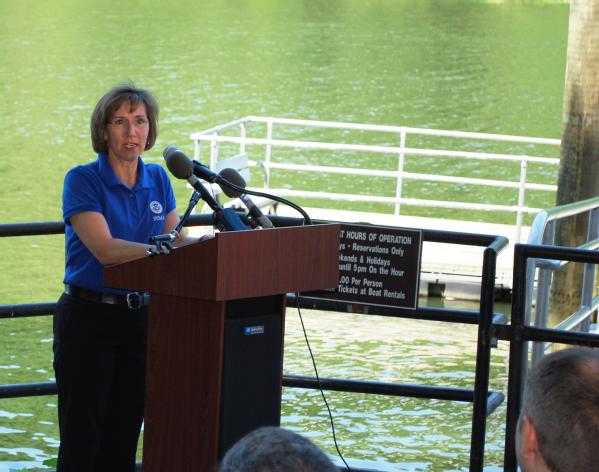
Sandra Knight, Mitigation Deputy Associate Adminsitrator, speaks at the Dam Safety Awarenss Day ceremony at Lake Needwood Dam.Rockville, Md., May 30, 2012 -- Sandra Knight, Mitigation Deputy Associate Adminsitrator, speaks at the Dam Safety Awarenss Day ceremony at Lake Needwood Dam.

The Lake Needwood Dam served as the focal point for Dam Safety Awareness Day because of its urban setting and the successful emergency action planning that took place in response to a severe leakage incident that occurred on July 19, 2006. The planning and response of that incident by state and local officials symbolize exactly what FEMA and its partners strive to achieve through the National Dam Safety Program: a “whole community” approach to emergency management that keeps Americans, their property, and the environment safe from dam failure. National Dam Safety Awareness Day is a day to acknowledge the important work that is being accomplished at all levels of government, and to make a commitment to continue this work to help and create a culture of preparedness and safety in all communities.

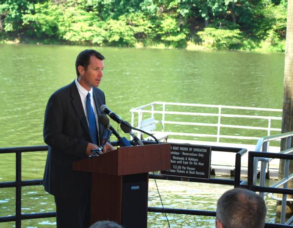
Manning, Deputy Administrator for Protection and National Preparedness, speaks about the National Dam Safety Program.Rockville, Md., May 30, 2012 -- Tim Manning, Deputy Administrator for Protection and National Preparedness, speaks about the National Dam Safety Program.

National Flood Insurance Program Reauthorization Needed

Author: 
Editor's Note: this blog post was updated May 16, 2012.

Flooding is the most common and costly natural disaster to affect every state across the country. Flooding is so common, in fact, that Congress authorized the creation of the National Flood Insurance Program, under the Federal Emergency Management Agency, to lessen the financial impact of flood disasters on individuals, business, and all levels of government. That authorization is set to expire next month, on May 31, and only Congress can provide the authority for continued funding of the program.

If Congress fails to reauthorize the NFIP beyond May 31, many individuals, families, businesses and local communities will find themselves left vulnerable to the devastating effects of flooding, because, the NFIP will be unable to issue new policies, renew existing policies, or increase coverage on existing policies.

Here are a few examples of how this can impact you:
  • If you are a property owner in a high risk flood area, who would normally be required to purchase flood insurance in order to purchase your home, you would be unable to obtain affordable flood insurance. The National Association of REALTORS estimates that a lapse in authorization jeopardizes an estimated 1,300 sales each day, or about 40,000 mortgage closings per month.

If you have an existing policy and continue paying your premiums, you can file a claim for flood-related damages and it will be processed. Claims for new policies, or policy renewals, where the policies were received and held by your insurance company during the lapse will not be paid until Congress reauthorizes the NFIP. In this instance, your insurance company can still investigate your claim under a “non-waiver” agreement, up to the point of payment. Under a “non-waiver” agreement, your insurance company may not pay your claim if Congress does not reauthorize the NFIP to pay claims during the period of lapse.

  • In addition, if the NFIP experiences a lapse in authorization, the cash flow into the program from premiums will diminish, and the NFIP may have to halt payment of your claim if you have recently experienced flooding. 
  • If you are a homeowner, renter, or business owner and you are unable to purchase NFIP flood insurance, or renew your existing policies, and are impacted by flooding, you may need to look to the services and recovery support provided by voluntary and faith based organizations, state and local governments, and possibly even to federal assistance programs in their recovery, such as the Small Business Administration, who can offer low interest loans, or FEMA’s Individuals and Households program, which can provided very limited assistance in the form of grants.

The NFIP identifies areas of flood risk; it encourages communities to implement measures to mitigate against the risk of flood loss; and it provides financial assistance to help individuals recover rapidly from flooding disasters. However, in recent years, a series of short-term reauthorizations and temporary suspensions of the NFIP have eroded confidence in the program among citizens and stakeholders, including state governments, tribal governments, local communities, individual policyholders, mortgage lenders, and the private insurance industry. To the individuals and business owners who live in an area with flood risk, have an upcoming mortgage closing that requires the purchase of flood insurance, and you need affordable flood insurance coverage, we urge you to apply for flood insurance immediately. It many instances, it takes 30 days for a flood insurance policy to take effect, and it must occur while the program is authorized.

Flood Safety Awareness Week Wrap-Up

Author: 

Today marks the close of Flood Safety Awareness Week -- during which, FEMA has worked to bring awareness of the risks flooding poses to many of our homes and communities. Floods are one of the most common hazards in the United States and no two flooding disasters are alike.

Some flooding events develop slowly, while others such as flash floods can develop in just a few minutes with little notice and without any visible signs of rain. Many disasters and emergencies share this characteristic – appearing dramatically with no warning signs much like tornadoes and earthquakes.

But there are meaningful and practical steps that you and your family can take to be prepared for all hazards, not just flooding, to stay safe and mitigate damage to property.

The first thing you can do is to be informed and know your risk; familiarize yourself with potential risk where you live and work. Knowing what to do before, during and after an emergency is a critical part of being prepared and may make all the difference when seconds count.

Here are some additional steps you can take now to ensure you’re prepared for potential future flooding:


  • Making a Plan: Your family may not be together when a disaster strikes so it is important to plan in advance and create an emergency communications plan. Know how you will get to a safe place; how you will contact one another; how you will get back together.
  • Building a Kit: Assemble the items you will need in advance of an emergency. You may be instructed to evacuate at a moment’s notice. Think about what you may need immediately after an emergency. This should include food, water and other supplies in sufficient quantity.
  • Get Involved: There are many ways to get involved especially before a disaster occurs. Your whole community can participate in programs and activities to make your families, homes and communities safer from risks and threats. 

To learn more about flood risks in your area, visit www.floodsmart.gov.

For more information on all hazard preparedness and ways you can protect your family before, during and after an emergency or disaster visit www.ready.gov.

Flood Safety: Be Aware, Be Prepared

Flood Safety Awareness Week is an excellent opportunity for all Americans to become more educated about the dangers that flooding can cause and what steps to take to be prepared for the risk of flooding.

All floods are not alike, though. Some develop slowly during an extended period of rain or during a warming trend after a heavy snow. Others, such as flash floods and severe weather, can occur very rapidly, without warning or even any visible signs of rain. That’s why it’s critical to be prepared for flooding no matter where you live.

Don’t be caught off guard. Get the facts. Know the risks. Take action to protect yourself, your family, your business, and your finances—before a weather event occurs and it’s too late.

One of the most critical ways you can protect your home or business and its contents from flooding – the nation’s most common and costly natural disaster - is to purchase flood insurance. It only takes a few inches of water in a home or business to cause thousands of dollars of damage. The time to get protected is now. Between 2006 and 2010, the average flood claim was nearly $34,000. Take a moment to think about that -- it’s more than many survivors can afford to pay out of pocket for damages due to flooding. While no one wants a flood to impact them, with federally backed flood insurance, you have an important financial safety net to help cover costs to repair or rebuild if a flood should strike.
Most standard homeowner policies do not cover flood insurance. Remember, it typically takes 30 days for a new flood insurance policy to go into effect, so get your policy now. An average flood policy costs around $600 a year, and rates start at just $129 a year for homes in moderate-to-low-risk areas.

The National Weather Service may not be forecasting severe Spring flooding this year, but don’t wait until a flood is happening to make sure you are protected. Take time now to learn more about flood risk and your options for insurance coverage by visiting www.floodsmart.gov, or by calling 1-800-427-2419.

For more information about flood safety, visit www.Ready.gov/floods.

Things You Can Do To Mitigate Against Flooding

Author: 

Flooding is the nation’s number one natural disaster, and it can occur inland, along the coast, and across every region of the country. Even though you may think your community has little or no risk of flooding, the reality is that anywhere it rains, it can flood. In fact, roughly 25 percent of all flood insurance claims are filed in low-to-moderate flood-risk areas. It is important to keep in mind that the risk of flooding isn’t based only on your community’s history, but on a variety of factors like rainfall, topography, river-flow and tidal-surge data, and changes resulting from new construction in your community. Those all play a part in what actual flood risk you face.

There are steps that you can take to prepare yourself and mitigate against damages. The first thing you can do is know your risk, and we have information on risk, including a One-Step Flood Risk Profile. Next, you should create an emergency communications plan and build an emergency kit to ensure you and your family are prepared for a flood. As part of having a plan, we also encourage you to consider your coverage. A flood insurance policy can protect your home, property, or business from the financial damages of flooding. Most homeowner’s insurance does not cover damage from flooding, so visit FloodSmart.gov to learn more.

In addition to these steps, there are also small flood proofing measures that you can take to help prevent, or minimize the impact of flooding to your home and its contents. A few examples include:

  • Elevate your furnace, water heater and electric panel in your home, if you live in a high flood risk area.
  • Install "check valves" to prevent flood water from backing up into the drains of your home.
  • When practical, homeowners can construct barriers (such as sandbagging) to stop floodwater from entering your home.
  • Seal walls in your basement with waterproofing compounds.

Homeowners around the nation have taken proactive measures, like these, to reduce their risk of damage from flooding. Proactive communities work on mitigating strategies through a combination of flood control projects and good floodplain management activities. In addition, FEMA hazard mitigation grants across the country have helped homeowners and communities affected by flooding, prevent future damages. Here are a few examples of how grants have helped protect properties from subsequent flooding.

In New Jersey, a homeowner elevated her home after flooding from severe storms in Spring 2007, protecting her from flooding during the storm surge resulting from Hurricane Irene in August 2011.

In Washington, a homeowner elevated his home after flooding in 2006 with the help of federal and county funding, and was able to avoid damages from flooding that occurred in 2009 when a nearby river surged and floodwaters went under the elevated home.

An inland community in North Carolina that was affected by storms in 1996 used state and federal funding to improve the town’s stormwater management system, which included piping improvements and installation of floodgates and retention ponds. In 2011, when Hurricane Irene brought massive downpours and strong winds, town officials were able to open the floodgates and allow the water to flow as it rushed through the town.

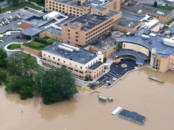
The photo below shows how a hospital in Binghamton, New York, averted major storm damage from flooding in 2011 because of a floodwall and other mitigation measures that were implemented with hazard mitigation grants following 2006 flooding.

Binghamton, Ny., September 8, 2011 -- A floodwall, built with hazard mitigation funds from the Federal Emergency Management Agency and New York State protected this vital property from flood waters that devastated other parts of the city, even as rising water from the Susquehanna River engulfed the hospital’s parking lot during Tropical Storm Lee.

Binghamton, Ny., September 8, 2011 -- A floodwall, built with hazard mitigation funds from the Federal Emergency Management Agency and New York State protected this vital property from flood waters that devastated other parts of the city, even as rising water from the Susquehanna River engulfed the hospital’s parking lot during Tropical Storm Lee.

To learn about flood risks in your area and for information on flood insurance, visit www.floodsmart.gov. For more information on flood preparedness tips and ways you can protect your family before, during and after a flood visit www.ready.gov/floods.

Turn Around Don’t Drown

Flooding is the leading cause of severe weather-related deaths in the U.S. claiming on average nearly 100 lives a year. Most of these deaths occur in motor vehicles when people attempt to drive through flooded roadways. Many other lives are lost when people walk into or near flood waters. This happens because people underestimate the force and power of water, especially when it’s moving. The good news is it is preventable with the right knowledge and tools.

A mere six inches of fast-moving flood water can knock over an adult. And it only takes 12 to 18 inches of flowing water to carry away most vehicles including large SUVs. If you come to an area that is covered with water, you will likely not know the depth of the water or the condition of the ground under the water. This is especially true at night, when your vision is more limited. Play it smart, play it safe. Whether driving or walking, any time you come to a flooded road, follow this simple advice: Turn Around Don't Drown.

Here are a few more tips to keep you safe during flooding:

  • Always plan ahead and know the risks before flooding happens. Monitor NOAA’s All-Hazards Radio, or your favorite news source for vital weather related information before, during and even after a disaster.
  • If flooding is expected or is occurring, get to higher ground FAST! Leave typical flood areas such as ditches, ravines, dips or low spots, and canyons.
  • Avoid areas already flooded, especially if the water is flowing fast. Do not attempt to cross flowing streams. Turn Around Don't Drown.
  • NEVER drive through flooded roadways. Road beds may be washed out under flood waters. Turn Around Don't Drown.
  • Do not camp or park your vehicle along streams and washes, particularly during threatening conditions.
  • Be especially cautious at night when it is harder to recognize flood dangers.
  • Never cross any barriers that are put in place by local emergency officials. Not only is this dangerous, but many states and communities levy steep fines for people that ignore barricades or other road closure indications.
  • Play it safe, Turn Around Don't Drown.

Visit noaa.gov for more Turn Around Don't Drown resources and visit www.weather.gov for the latest weather forecast information.

The Advanced Hydrologic Prediction Services


This week, the National Oceanic and Atmospheric Administration (NOAA) and FEMA are once again partnering for National Flood Safety Awareness Week.  Each day of National Flood Safety Awareness week, we will provide key information related to flood hazards, and ways to protect yourself and your property.

The influences of weather, water and climate on our daily lives and economic well being are manifold, and at times profound. A fact highlighted by the devastating and heartrending events of the past few years.

NOAA's National Weather Service (NWS) provides weather, water, and climate forecasts and warnings to protect life and property and enhance the national economy.  To fulfill this important mission, skilled NWS meteorologists and hydrologists use state-of-the-art science and technology to monitor and predict weather, water and climate impacts for our nation and its citizens 24 hours a day, every day of the year.

Floods are our nation’s most costly natural disaster and, on average, is the leading cause of severe weather-related deaths.  Floods have claimed an average of 94 lives a year and $10.2 billion in economic damages in the decade 2001-2010 alone. Watch The Water’s Fury (Quicktime file) to see the power of water.

While floods are not preventable, the loss of life and property can be reduced significantly with more timely and accurate forecasts and warnings.  An important means by which the NWS produces and distributes flood and water resource forecasts and information is through the Advanced Hydrologic Prediction Service, known as AHPS (pronounced A-Haps).

AHPS is an ongoing effort by the NWS to continue modernizing its hydrologic services and provides new information and products through the infusion of new science and technology.  It is a web-based suite of accurate and information-rich forecast products in graphical form that enables government agencies, private institutions, and individuals to make more informed, risk-based decisions to mitigate the dangers posed by floods and droughts.

Some examples of the products and information from AHPS include: hydrographs combining current water level observations from the U.S. Geological Survey with NWS river forecasts; extended range (i.e., 90-day) probabilistic forecasts conveying the chance a river will exceed minor, moderate, or major flood levels; inundation maps for water levels from flood stage through the flood of record, depicting where and how deep the flood waters will be in a neighborhood or community thereby enabling emergency managers and other decision makers to preposition people and resources to most effectively mitigate the impacts of a flood; historical floods impacts, and much more.

The broad reach of AHPS extends the range of forecasts from short-term (up to 6 hours) to long-term (out to weeks and months) and provides the public with more detailed and accurate answers to the following questions:


  • How high will the river rise?
  • When will the river reach its peak?
  • Where will the flooding occur?
  • How long will the flood last?
  • How long will the drought continue? and
  • How certain is the forecast?

AHPS forecast products and information support decisions regarding the operation and management of flood-control structures.  Emergency management officials at the Federal, state, territorial, tribal and local and state levels use these forecasts to fight floods, evacuate residents, and to take other measures to mitigate the impact of flooding.  Also, these products are used by a wide range of people, such as barge and dam operators, power companies and municipal water supply officials, recreational users, farmers, households, businesses, and environmentalists. Anyone and everyone who makes water-based decisions benefits from AHPS.

Get ready, be prepared and be FloodSmart before the flood starts.

Stay current with flood risk in your area with the latest official watches and warnings at weather.gov. For detailed hydrologic conditions and forecasts, click the "water" tab.

Seeking Input on a New and Improved Approach for Mapping Flood Risk

Author: 

As part of our ongoing efforts to reform and strengthen the National Flood Insurance Program, FEMA has been working with members of Congress and other stakeholders to revise our process for mapping the flood risk of communities and families living behind levees. Our goal is to improve the way we map that risk – so families have more precise information when making decisions about how to protect their homes and properties.

In recent months, we have explored multiple approaches by seeking extensive input from stakeholders, including independent technical experts and the public.

Based on this input, we now are proposing a new mapping process for levees that will help us compile more precise technical data and allow us to more effectively assess the actual flood risk faced by citizens in communities throughout the country. Specifically, our proposed approach would strengthen our current process by helping communities demonstrate the degree of protection that a levee may provide to the surrounding communities. Currently, our maps don’t recognize any level of protection if a levee has not been certified to meet FEMA standards.

And as we have throughout this effort, we will continue to seek comments from stakeholders and the public on this proposal to help us finalize this new process. This public comment period will be open until January 30, 2012. Anyone can get more information on this approach and provide comments by visiting the federal register.

As with other recently-adopted tools that have increased our mapping accuracy, such as digital mapping technology, these new methods will help us continue to improve our flood mapping and analysis efforts.

Flood mapping remains a team effort that requires close coordination between our agency, our federal, state, local, tribal and territorial partners and communities – and of course, the public. As we continue to work to improve our flood mapping process, families and businesses can better understand the flood risk they face within their own communities and take steps to protect themselves and their homes against a potential flood. These steps can include flood proofing techniques to mitigate flood risk to their own homes, supporting good land use and building codes in their communities, developing a family communications plan, putting an emergency kit together, and investing in flood insurance. We encourage families and businesses to learn more by checking out http://www.floodsmart.gov/.

North Dakota Partnerships Pave the Way for Recovery, Safer Future

Posted by: Public Affairs

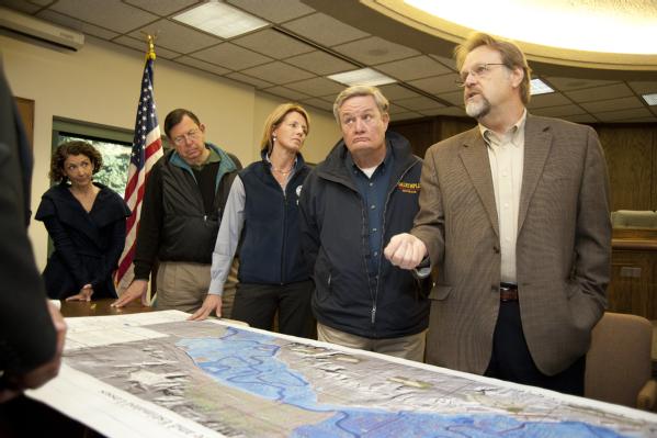
Officials look over a map of Minot, North Dakota.
Minot, ND, October 20, 2011 -- David Miller (right), Associate Administrator of the FEMA's Federal Insurance and Mitigation Administration, North Dakota Governor Jack Dalrymple (second from right), FEMA Federal Coordinating Officer Deanne Criswell (center), FEMA Associate Administrator of Response and Recovery William Carwile (left), and FEMA Region VIII Flood Insurance and Mitigation Division Director Jeanine Petterson discuss flood recovery concerns with engineers and other state and local officials at Minot's City Hall.

Recently, David Miller, Associate Administrator, Federal Insurance & Mitigation Administration, and Bill Carwile, Associate Administrator for Response and Recovery, visited North Dakota. During their visit, they met with top state and local officials, toured flood damaged areas from the air and the ground, and saw first-hand the impacts of flooding along the Souris and Missouri Rivers and in the Devils Lake Basin, including the Spirit Lake Sioux Tribe. They came to look, listen and learn about the challenges and the hopes of area leadership.

Their goal was to look for ways to improve the local, state, tribal, private sector and federal partnerships needed for ongoing recovery and future mitigation.

David Miller shared his thoughts on the trip:


Bill and I toured areas of Bismarck and Mandan, Minot/Ward County and Devils Lake. We visited with FEMA and U.S. Army Corps of Engineers staff and met with state and local leaders, including Governor Dalrymple, Adjutant General Sprynczynatyk, State Flood Recovery Coordinator Major General Sagsveen, and representatives from the North Dakota Department of Emergency Services. On Friday morning, I also met with Senators Conrad and Hoeven and Representative Berg, and locals leaders representing the Souris River Basin, including Mayors Curt Zimbelman and Jerome Gruenberg.

Throughout our visit we engaged in a discussion of the recovery efforts for each of the affected areas. I listened to the passionate and well articulated concerns of state and local leaders and heard about their commitment to the future. It is apparent that while each area has unique challenges, the foundation for a safer future rest with building a sustainable, well-coordinated and comprehensive approach to their ongoing flooding risks.

Strategic Long Term Recovery
I returned from the visit to the Souris River Basin impressed that state and local officials are taking the lead to develop a strategy and program for recovery that will include floodplain management, control projects, and acquisitions along with plans for the environment, historical considerations and future development. These plans may include both structural and non-structural solutions. While flood protection needs to be driven at the state and local level, I see an opportunity for federal support and participation as their concepts are flushed out, goals further defined and specific projects indentified.

It was extremely valuable for me to visit the Devils Lake Basin, especially from the air – for which I thank the North Dakota National Guard. This is an area I have long heard about but this was my first visit. I want to thank the local leaders who took the time to brief me on the situation, and for their straightforward and clear summary of how this flood event (that began in 1993) has impacted their infrastructure, their communities and most importantly their citizens. I know we will have continued involvement as part of the state and Army Corps of Engineers-led efforts and I am committed to exploring ways our programs, can be used to support the Corps’ recovery and mitigation strategies.

David Miller, Associate Administrator, Federal Insurance and Mitigation Administration and William Carwile, Associate Administrator, FEMA Response and Recovery survey ongoing recovery efforts in Minot.
Minot, ND, October 20, 2011 -- David Miller, Associate Administrator, Federal Insurance and Mitigation Administration and William Carwile, Associate Administrator, FEMA Response and Recovery survey ongoing recovery efforts in Minot following historic flooding from the Souris River this Spring. FEMA is working with state and local partners to provide assistance to those who were affected by the flooding.

Bill Carwile emphasized the importance of seeing a disaster first-hand, and the importance of partnerships:


Let me add that I too benefited from seeing first-hand the complexities surrounding long-term recovery challenges in North Dakota. Seeing a disaster from the ground is always beneficial, but this trip proved especially valuable thanks to the time we were able to spend with the governor, state officials, and community leaders. I focused my time in the Souris River Basin and the surrounding areas.

Like David, I found both the aerial perspective and the ground tours extremely valuable. But nothing impacted me more than driving through flood damaged neighborhoods and then walking through a home that was destroyed. While state and local leaders, with supplemental support from FEMA, the private sector, other federal agencies, and the volunteer organizations have made progress, good progress, it is clear that there is still a long way to go. And while the challenges are great, so are the opportunities. One of my specific recommendations is that we coordinate with the State to evaluate the need to exercise components for the National Disaster Recovery Framework to help support the ongoing recovery efforts.

My message to the local community is to continue to build your local, state, federal and private sector team. As I told FEMA Administrator Craig Fugate when I returned from North Dakota, we need to do all we can within FEMA to support the state, flood-impacted communities, and individuals as they continue the efforts to rebuild, and define projects and strategies for future flood protection.

Pages

Back to Top