Blog

Main Content

Monitoring the Severe Weather and Excessive Heat

Author: 

Our thoughts and prayers are with those whose lives have been affected by the storms that struck many states last night, including parts of Indiana, Kentucky, Ohio, West Virginia, Virginia, Maryland, Pennsylvania and the District of Columbia.

We’re continuing to monitor the storm’s aftermath and we’re working closely with all of the states that were affected. If you are in an area impacted by the storm last night, please continue to listen to local officials, and make sure you do not touch downed power lines or objects in contact with a downed power line. When it’s safe to do so, report down trees and power lines to your local police or utility company.

The National Weather Service has issued Excessive Heat Advisories in many areas that have been affected by last night’s severe weather and we urge everyone to take safety precautions, especially if you don’t have power.

  • Check on family, friends, and neighbors who do not have air conditioning, especially those who spend much of their time alone.
  • Drink plenty of water, even if you do not feel thirsty.
  • Stay indoors as much as possible and limit exposure to the sun.
  • Stay on the lowest floor out of the sunshine if air conditioning is not available.
  • If you don’t have power, limit the amount of time your refrigerator is open to keep food cool.
  • Never leave children or pets alone in closed vehicles.
  • Listen to local officials for information about cooling centers.
  • If you don’t have power or phone service, try texting to let friends and family know you’re OK.
  • Listen to Local weather forecasts for critical updates from the National Weather Service and stay aware of temperature changes.

From an operational perspective, some of our activities include:

  • At the request of the State of Ohio, a FEMA liaison officer is deployed to the Ohio state emergency operations center to support state response efforts as needed.
  • FEMA has also deployed an Incident Management Assistance Team to West Virginia to work side by side with the West Virginia Division of Homeland Security and Emergency Management.
  • FEMA remains in close contact with federal partners at the National Weather Service forecast offices, the U.S. Army Corps of Engineers and the U.S. Department of Energy.
  • FEMA’s National Response Coordination Center in Washington, D.C. is activated, and our Regional Response Coordination Centers in Chicago, Ill. and Philadelphia, Pa. are activated to support impacted states if requested.

Continue to follow local weather forecasts as weather conditions can change unexpectedly, and please remember to check on your neighbors and stay in touch with friends and family to ensure everyone is OK.

What We’re Watching: 6/29/12

Author: 

At the end of each week, we post a "What We’re Watching" blog as we look ahead to the weekend and recap events from the week. We encourage you to share it with your friends and family, and have a safe weekend.
 

President Barack Obama tours fire damage with elected officials and firefighters in the Mountain Shadows residential neighborhood in Colorado Springs, Colo., June 29, 2012. (Official White House Photo by Lawrence Jackson)

Ongoing wildfire response
 

If you have been watching the news this week, you’re probably familiar with the ongoing wildfire fight happening in many communities out in the Rocky Mountain area of the country. Our federal partners such as the U.S. Forest Service and Department of the Interior are taking the lead on deploying federal assets, equipment, and personnel to directly support the fire fight. Today, President Obama visited Colorado to tour the damaged areas and meet with federal, state and local officials to ensure they had the full support of the federal government.

As I wrote on Wednesday, FEMA continues to closely coordinate with our federal, state, local, and tribal partners as they battle the blazes and focus on the safety of people and property. Since June 1, FEMA has authorized over 10 Fire Management Assistance Grants to support the firefighting efforts in Colorado, New Mexico, Utah, and Montana. Earlier today, President Obama made additional federal support available to those in Colorado affected by the wildfires in El Paso and Larimer counties – such as crisis counseling and disaster unemployment assistance.

We will continue to closely monitor the wildfires, and you can find out more about the federal government’s role at National Interagency Fire Center website. And if your community is vulnerable to wildfires, make sure you visit Ready.gov/wildfires to learn how to prepare your family, home, or business.

Assessing the effects of Debby

Another popular topic in newscasts this past week was the torrential rain brought to the southeast by tropical storm Debby. Even though national news coverage has quieted about the storm’s effects, we are working closely with our partners at the Florida Division of Emergency Management assessing the flood damages. We are currently conducting damage assessments along with the state to determine if additional support is needed for local governments or affected individuals. Visit the Florida Division of Emergency Management website for more updates, or check back on our blog.

Tropical storm Debby is also a good reminder that hurricane season is here, so the time to prepare is before the next storm forms. Even if you live in an inland area, severe tropical weather can bring large amounts of rain – so be sure to visit Ready.gov/hurricanes to find out how you can get prepared.

Staying cool

As we move into the weekend, a dangerous heat wave continues its march across the country. National Weather Service forecasts are calling for above average temperatures for much of the East Coast, so here are a few reminders for lessening the impact of the heat:
 

  • Stay inside during the hottest part of the day. If you don’t have air conditioning, stay on the lowest level of your home or office, away from the sun.
  • If it’s hot for you, it’s also hot for your animals. Keep them in the shade and make sure they are drinking plenty of water.
  • Follow your local forecast. Keep up with the conditions in your area and heed any advice by local officials or your local National Weather Service forecast office. Visit weather.gov or mobile.weather.gov on your phone to get your forecast now.  

For more tips on beating the effects of the heat, visit Ready.gov/heat.

Fourth of July Safety

And as we go into the Fourth of July holiday week, please remember to safely celebrate our nation's independence. The safest way to enjoy fireworks and pyrotechnics is through professional displays, not home use. So enjoy the holiday in a safe way and learn more about firework safety from the U.S Fire Administration.


Voluntary Organizations Key to Colorado Wildfire Fight

Author: 

First responders, volunteers, and community and voluntary organizations – these are usually the first people on the ground to help following a disaster.  These key members of the emergency management team are vital in helping communities and individuals prepare for, respond to, and recover from disasters and are invaluable links between the communities they regularly serve and tribal, local, state, and federal government.

The National Voluntary Organizations Active in Disaster (National VOAD) is a coalition of 53 national nonprofit organizations and 55 State/Territory members, representing hundreds of additional organizations, that share knowledge and resources throughout the disaster cycle – preparation, response and recovery – to help disaster survivors and their communities.  Voluntary organizations, including many faith based organizations, are actively supporting the states and local governments engaged in wildfire response efforts.  As wildfire response efforts continue throughout Colorado, the members of the Colorado VOAD (COVOAD) provide aid and relief services to disaster survivors, volunteers, and the thousands of firefighters working to control the growing fires across the state.

Organizations such as the American Red Cross, the Salvation Army, United Way and Adventist Community Services have been working tirelessly since the beginning of response efforts to set up donation centers, provide meals and shelters to displaced residents and provide needed supplies. Several other organizations have been in contact with the COVOAD office to offer assistance including Mennonite Disaster Service, Southern Baptist Convention North American Mission Board, and other local partner organizations.

With thousands of firefighters and first responders continuing to come together to bravely fight the blazes on the frontline, there are many others looking for ways to help. As the fires continue to spread and new fires emerge, we encourage individuals interested in helping to consider a monetary donation to the organization of their choice.

Financial support to voluntary agencies responding to disasters is the most effective way to help disaster survivors and response efforts in Colorado. Providing monetary donations allows disaster agencies to purchase exactly what is needed.

For more information on what you can do to help, please visit www.nvoad.org.

For agencies actively engaged in Colorado, visit www.helpcoloradonow.org, or contact Colorado 2-1-1.

Debby Update 3: Preparing for flooding

Author: 

Posted by: Lars Anderson, Director, Public Affairs

We’re continuing to monitor Tropical Storm Debby as it continues to create dangerous conditions along much of the Gulf Coast. According to the National Hurricane Center’s forecast at 5 p.m. Eastern time today, Debby is expected to bring large amounts of rain to affected areas – especially northern and central Florida, southeast Georgia, and coastal South Carolina. In some areas, over 15 inches of rain is expected this week.
 

June 25 - National Hurricane Center projected rain totals for the next three days. Image originally inserted as of 5 p.m. Eastern time.

At this time, Debby’s biggest threat for those in the affected area is flooding. Make sure you’re staying up to date with your local weather forecast and taking precautions to stay safe in case of flooding. Here are few safety tips if you are in Debby’s projected path:

  • If you have to leave your home, do not drive through flood waters. Even a small amount of moving water can cause you to lose control of your vehicle. And if you see standing water on the roadway, do not try to drive through it. * Turn around, don’t drown *
  • Keep up with updates from your local officials. If they give the order to evacuate, do so immediately. Remember, evacuation orders come from local officials, not FEMA. 
  • Severe weather watches and warnings may happen quickly, so be familiar with flood terminology, like:
    • Flood Watch - Flooding is possible. Tune in to NOAA Weather Radio, commercial radio or television for information. 
    • Flood Warning - Flooding is occurring or will occur soon; if advised to evacuate, do so immediately. 
    • Flash Flood Watch - Flash flooding is possible. Be prepared to move to higher ground; listen to NOAA Weather Radio, commercial radio or television for information. 
    • Flash Flood Warning - A flash flood is occurring; seek higher ground on foot immediately. 
  • Find more on how to keep your family, home, or business safe from the effects of a tropical storm at Ready.gov/hurricanes


What we’re doing 
We continue to closely monitor tropical storm Debby at our offices in Atlanta, Denton, Texas, and Washington, D.C. Our staff is in close contact with state officials in potentially affected states including Florida, Georgia, Mississippi, Alabama and South Carolina. In Florida, a FEMA liaison officer is onsite at the Florida Emergency Operations Center, after being requested by the state, to help coordinate if additional support is needed.

While we will continue to provide tropical storm Debby updates through our blog, Facebook page, and Twitter accounts – the best place to get up-to-date information is from the National Hurricane Center, at:

FEMA Continues to Monitor Tropical Storm Debby

Author: 

We’re closely watching Tropical Storm Debby as she continues to make predicting her path difficult due to conflicting forecast models based on computer simulations.  With their latest forecast, officials have indicated that this is a very difficult and highly uncertain forecast.  Because of this uncertainty, we are urging residents all along the Gulf to be focusing on their preparedness efforts.

The Administration, through FEMA and our federal, state and local partners is closely monitoring the storm and its potential impacts.  We remain in close contact with emergency officials in states all across the gulf coast to ensure there are no unmet needs.

History has proven that tropical systems don’t necessarily follow what forecasters think they would or should do even with sophisticated modeling.  Recent examples are Hurricane Jeanne which looped around in the Atlantic before striking Florida in 2004, and Ivan, also in 2004, that managed to make landfall on three occasions.

With the potential changes in the forecast, what do you need to know most?  As tropical waves or tropical storms can bring heavy rains and high winds, we urge coastal residents to monitor weather conditions by listening to your local radio and television news outlets, or by listening to NOAA Weather Radio. You can check your local forecast at http://www.weather.gov/ & http://www.hurricanes.gov/ and on your phone at mobile.weather.gov & www.hurricanes.gov/mobile.

It’s vitally important that you take steps to prepare your property and family, and you should take steps now to get prepared for potential severe weather. Visit Ready.gov/hurricanes (Listo.gov para español) to learn how to prepare your home and family for a hurricane or tropical storm, including building an emergency supply kit and creating a family emergency plan.`

Everyone should also familiarize themselves with the terms that are used to identify a severe weather hazard and discuss with your family what to do if a tropical storm watch or warning is issued in your area. Terms used to describe severe tropical weather include the following:

•       A Tropical storm watch means that tropical storm conditions are possible, in this case within 24 hours.
•       A Tropical storm warning means that tropical storm conditions are expected within 36 hours.
•       A Hurricane watch means that hurricane conditions are possible within 48 hours.
•       A Hurricane warning means that hurricane conditions are expected within 36 hours.

We’ll continue to monitor the storm and provide updates as it warrants, and if you are in the potential areas, please listen to and follow the instructions of local officials. We’ll also provide updates on Twitter and Facebook, so you can follow us there too. 

Tropical Storm Debby forms in the Gulf of Mexico

Author: 

Today’s 5:00 p.m. advisory from the National Hurricane Center has officially marked the development of Tropical Storm Debby in the Gulf of Mexico with estimated winds speed of 50 MPH and moving slowly in a northerly direction. We’re continuing to monitor the weather situation in the tropics through our regional offices in both Atlanta, Ga., and Denton, Texas, and here at headquarters. We are prepared to support our state, local, tribal and territorial partners as necessary.

The storm is located 220 miles South-Southeast of the mouth of the Mississippi River, and a Tropical Storm Warning is in effect for the Coast of Louisiana from the mouth of the Pearl River westward to Morgan City.

Since there is some uncertainty in the storm’s speed and motion we urge all residents of the Gulf Coast to pay close attention to weather developments over the next several days – especially those living along the northern Gulf Coast.

You will always hear us at FEMA talk about the need to be prepared. With the formation of Debby in the Gulf (and due to the uncertain track) we strongly encourage you to take the time to prepare your family, home or business to lessen the impact of a tropical storm or hurricane. If you’re unsure about where to start, visit Ready.gov/hurricanes today to learn how to make an emergency plan and how to create a family emergency kit.

Staying up to date with the latest tropical forecast information over the weekend and into early next week (as well as during all of hurricane season) is easy. Here is how you can get the latest from the National Hurricane Center:

We'll continue to post updates (as they are needed) here on the blog, and on Twitter and Facebook.

What We're Watching: 6/22/12

Author: 

At the end of each week, we post a "What We’re Watching" blog as we look ahead to the weekend and recap events from the week. We encourage you to share it with your friends and family, and have a safe weekend.

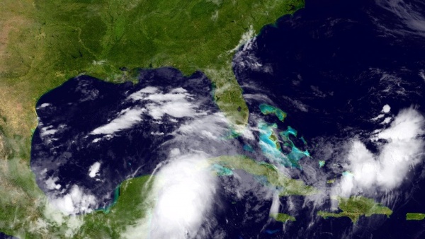
satellite photo of gulf of mexico as of june 22, 2012

June 22, 2012 - Satellite photo from the National Hurricane Center showing an area of low pressure organizing near the Gulf of Mexico.

Storm activity near the Gulf of Mexico
 
Earlier this week, the first hurricane of the 2012 Atlantic hurricane season formed (Hurricane Chris), but you may not have heard much about it since it wasn’t a threat to the U.S. or its territories. Although Chris didn’t make many waves (in the media at least), we’re closely monitoring a tropical system much closer to home near the Gulf of Mexico.

National Hurricane Center forecasts say it’s probable that this system will develop into a tropical cyclone in the next 48 hours – so all those along the Gulf Coast should stay up to date with what’s happening.

Now is the time to prepare your family, home or business to lessen the impact of a tropical storm or hurricane; don’t wait until a storm is approaching your area. If you’re unsure about where to start, visit Ready.gov/hurricanes today to learn about the risks in your area, how to make an emergency plan, and how to create a family emergency kit.

And staying up to date with the latest tropical forecast information during hurricane season is easy. Here is how you can get the latest from the National Hurricane Center:

How to beat the heat

No, I’m not talking about how to beat the Miami Heat, who won the NBA Championship last night. I’m referring to the abnormally high temperatures that many places in the U.S. experienced this past week. The National Weather Service is predicting more heat for next week, especially for the middle of the country.

So if the mercury in your thermometer rises next week, remember to check on those without air conditioning to make sure they are staying cool. And the age-old tips of drinking plenty of water and staying inside during the hottest part of the day are still effective – but you can find other useful heat safety tips at Ready.gov/heat.

Your feedback

As Shayne Adamski blogged yesterday, we’re watching for your feedback on the preview of the new fema.gov site. The redesigned site will be easier to navigate and help users quickly find the information they’re looking for – but we want you to “kick the tires” before we make the full switch over to the new site. So check out the new site at preview.fema.gov and leave a comment below or send us an e-mail at FEMA-New-Media@fema.dhs.gov.

Next weeks’ Think Tank call

Next week’s Think Tank call (June 28, 12 p.m. EDT) focuses on increasing coordination and collaboration within emergency management, healthcare and public health. The Think Tank provides a platform for people across the entire emergency management team, a team that includes members of the public, to share their best ideas on improving emergency management.

FEMA Deputy Administrator Rich Serino will co-host the call with the Office of the Assistant Secretary for Preparedness and Response within the Department of Health and Human Services. Check out fema.gov/thinktank for more information, and I hope you can join us for the next week’s call:

Time: 12:00 - 2:00 p.m. EDT (11:00am – 1:00pm Central)
Call-In Number: 888-989-4401
Passcode: Think Tank Captioning for the event
Twitter: #femathinkank

SNEAK PEEK: The Next Iteration of FEMA.gov

Today we are taking a step forward and pulling back the curtain with a preview of the next iteration of FEMA.gov to give you the opportunity to take a tour of the new site, and to “kick the tires” as the saying goes.

When we began the process of our redesign, we started with the goal of creating a site that is more user-friendly, with up-to-date information, and easier to navigate. To reach this goal, some of the changes we made are: re-organizing the main content sections; adding drop-down menus; and integrating the “search” function to a greater extent within the website.

As we move forward through this process, there are a few important points to note:

  • First, in an effort to provide options and ease users into how the new site functions, the new re-designed site will be available while the old FEMA.gov site remains active. This will provide individuals the opportunity to be able to access information in the manner they are most comfortable and assist with easing them into a transition to the new site. 
  • Second, we want to let you know that through this re-design process we have been updating much of the content that you will find on FEMA.gov. As we continue to work, we still have some pages that are being brought up-to-date. So please understand that content continues to flow and is being updated as quickly as possible. 
  • Finally, like many projects of this magnitude, we anticipate that there will be some technical bugs in the system and we will work to address them as expeditiously as possible.

In the end, it is important for us to know what you, the user, thinks about the new site. Let us know what you think – the good, the bad, and everything in between. Click around the site and email us your thoughts: FEMA-New-Media@fema.dhs.gov So once we’ve kicked the tires of the new site, what’s next?

Once we complete the work on the site and we are comfortable that it is working and functioning in a way that you have come to expect, we’ll take down the current site and replace it with the new version of the site. A point to note for some of our users who regularly link to some of FEMA’s content. When the new site goes live, links that you have bookmarked or links to our content may no longer work. So, as we move forward in the process, we will be asking web site owners, bloggers, etc, to assist us by making sure if you have links to FEMA.gov from your sites that you update links to our site.

Keep watching this space and we’ll keep you updated and let you know when you should start changing the links. Thanks again for visiting the new, improved, and easier-to-navigate FEMA.gov!

What We're Watching, 6/15/12

Author: 
Editor's Note: This blog was updated at 3:40 p.m.
 
At the end of each week, we post a "What We’re Watching" blog as we look ahead to the weekend and recap events from the week. We encourage you to share it with your friends and family, and have a safe weekend.

High Wildfire Activity Continues 
Last week, we mentioned the threat of potential wildfires – unfortunately, Arizona, California, Colorado, Nevada, New Mexico, Utah, and Wyoming are all experiencing fire outbreaks that are ongoing. We continue to closely monitor the wildfire activity from our regional offices in Denver and Denton, Texas, while thousands of first responders and firefighters from local, state, federal and tribal agencies are fighting the fire on the ground to protect lives and property. Federal agencies have made approximately 5,000 firefighters available to suppress fires so far.

For the High Park Fire (Colorado) and Little Bear Fire (New Mexico), one way FEMA is supporting the firefighting efforts is through Fire Management Assistance Grants. These grants make FEMA funding available to pay 75 percent of the state’s eligible firefighting costs, but do not provide assistance to individual home or business owners.

Earlier this week, we also sent an Incident Management Assistance Team to the Colorado Emergency Operations Center to work side by side with state officials to monitor and support the High Park Fire fight. For more information on the federal government's role during wildfires, visit the National Interagency Fire Center website, or view their latest situation report (PDF).

If you live in an area that is currently being affected by wildfires, or an area that is susceptible to wildfire outbreaks, here are a few tips to remember:
  • Follow the direction of local officials – I cannot stress this enough. Local officials are most familiar with the conditions on the ground, and any evacuation orders originate from local officials (evacuation orders do not come from FEMA). If you are told to evacuate, leave immediately. 
  • Be familiar with evacuation routes – Local officials will announce if an evacuation is required, and they will also have information on the safest way to leave the area. So become familiar with possible evacuation routes ahead of time, that way you will be familiar with them during an emergency. 
  • Stay informed of the latest developments – Stay up to date by following local news reports or updates from local officials. For example, Larimer County, Colorado  have been updating this website and their @LarimerSheriff Twitter account to keep residents updated about the High Park Fire. Also, keeping your NOAA Weather Radio close by is useful for getting the latest severe weather developments.
You can find more wildfire safety tips at Ready.gov/wildfires, or on our mobile site at m.fema.gov/wildfires.htm. Have a safe weekend, and we will provide further updates about FEMA's role regarding the increased wildfire activity on this blog as needed.

Father's Day Gift Ideas
For all you last minute shoppers still looking for the perfect gift to give dad for Father’s Day, why not also give a gift of preparedness and get dad something that may be useful during an emergency like a flashlight with extra batteries, a NOAA weather radio or a cell phone charger for his car? In addition to a traditional gift like ties, socks or golf balls, help get your dad prepared no matter where he is -something small and creative like a keychain flashlight can be just the motivation needed to help your loved ones get prepared – if they aren’t already.

Visit www.ready.gov for more creative gift ideas.

Have a safe weekend and Happy Father’s Day!


Supporting Legislative Efforts to Recognize the Sovereignty of Tribal Governments When Emergencies or Disasters Strike

Author: 

In my December blog, I expressed the Obama Administration’s support for amending the Stafford Act to allow federally recognized tribal governments to make a request directly to the President for a federal emergency or major disaster declaration. Under current law, only States, through the Governor, can make such requests.

I’ve re-emphasized my support for amending the law by sending letters to Congressional Committee Chairmen to offer FEMA’s support for S. 2283. A change to the Stafford Act would enhance our ability to respond directly to tribal governments’ declaration requests regardless of State or county boundaries or jurisdictions. I’m giving my firm commitment to actively work with Indian Country and Members of Congress to support and facilitate the passage of this legislation.

Specifically, the letters I sent today are recommending that Congress take swift action to pass this legislation. If Congress passes and the President signs such legislation into law, my office will act promptly in the development of appropriate regulations and policies for implementation.

Through the years, I’m proud of the close working relationships we developed at FEMA with recognized tribal governments across the country, especially as it relates to disaster response, recovery and mitigation activities. Based on these experiences, I’ve seen great success and some challenges. I believe that amending the Stafford Act to allow federally recognized tribal governments to make a request directly to the President for a federal emergency or disaster declaration, will only improve our coordination efforts and build stronger more resilient communities.

The U.S. Government has a unique government-to-government relationship with federally recognized tribal governments based on the U.S. Constitution, statutes, regulations, treaties, executive orders, executive memoranda and policies. Amending the law would acknowledge the sovereignty of federally recognized tribes, enhance FEMA’s working relationship with tribal governments, and improve emergency and disaster responsiveness throughout Indian Country.

I’m looking forward to the day when the changes I have communicated here are made law and we are better situated to improve our coordination efforts with tribal governments and Indian Country. Visit FEMA.gov/government/tribal for additional information.

We will continue to follow the progress of this legislation closely and I’ll keep you posted on developments.

Pages

Back to Top